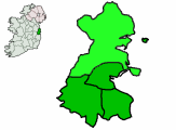
County Fingal
| map | |
|---|---|
| Basic data | |
| Country: | Ireland |
| Administrative headquarters: | Swords |
| Province: | Leinster |
| Irish name: | Fine gall |
| Surface: | 453 km² |
| Residents: | 296,214 (2016) |
| License Plate: | D. |
County Fingal ( Irish : Fine Gall ) is a county in the Republic of Ireland . It is not one of the country's 26 historic counties , but was created on January 1, 1994 when County Dublin was administratively divided.
history
The Irish name is derived from the term finn-gall ("bright stranger"), used in chronicles from the 9th to 11th centuries. Century, which are written in Old Irish and Central Irish, specific Viking groups are called, which had settled in Ireland and the Hebrides in the early Middle Ages . Other Vikings are referred to in the chronicles as dhub-gall ("dark stranger"). Which strains are meant by these terms is still controversial in research.
Fingal was first mentioned as a place name in 1208 in a document from King John of England , with which Walter de Lacy was confirmed as Lord of Fingal. The Local Government (Dublin) Act established County Fingal in 1993, but the official name has not yet become fully established in common parlance. North County Dublin is also often mentioned. Swords has been the administrative headquarters of Fingal since 2001 . Until then, the Fingal County Council had its provisional seat in Dublin .
geography
County Fingal spans the coastline north of Dublin City to the River Delvin. It extends south to the Liffey and is bordered by Counties Louth , Meath , Kildare and South Dublin . Fingal also includes Dublin International Airport and the Howth Peninsula .
economy
Fingal is Ireland's premier horticultural center. About 50% of the national vegetable production and 75% of the national greenhouse harvest come from the county. Since the urban conurbations (Blanchardstown, Swords etc.) are expanding rapidly, there is less and less space for agricultural production. Many settlements mainly serve as dormitories for the capital Dublin. In addition, fishing still plays a certain role; Howth is one of the main fishing ports on the east coast.
politics
The distribution of seats in Fingal County Council after the local election on May 23, 2014:
| Political party | Seats |
|---|---|
| Fianna Fáil | 7th |
| Fine Gael | 6th |
| Sinn Féin | 6th |
| Labor Party | 4th |
| Green party | 2 |
| Non-party, smaller groups | 15th |
Cities
The biggest cities are:
| local community | Residents |
|---|---|
| Blanchardstown | 63.120 |
| Swords | 33,998 |
| Castleknock | 21,457 |
| Balbriggan | 21,722 |
| Malahide | 14,937 |
| Rush | 8,286 |
| Howth | 8,196 |
| Skerries | 9,535 |
| Portmarnock | 8,979 |
| Donabate | 5,499 |
(Status: 2006)
Web links
Individual evidence
- ↑ Roderick W. McDonald: Outsiders, Vikings, and Merchants: the context dependency of the Gall-Ghàidheil in medieval Ireland and Scotland. In: Journal of the Australian Early Medieval Association, 2015, vol. 11, p. 67 ff.
Coordinates: 53 ° 30 ′ N , 6 ° 15 ′ W


