St. Michaelisdonn airfield
| St. Michaelisdonn | |
|---|---|

|
|
| Characteristics | |
| ICAO code | EDXM |
| Coordinates | |
| Height above MSL | 38 m (125 ft ) |
| Transport links | |
| Distance from the city center | 2.22 km southeast of Sankt Michaelisdonn, 8 km north of Brunsbüttel |
| Basic data | |
| opening | October 13, 1952 |
| operator | Dithmarscher Luftsportverein e. V. |
| surface | 30 ha |
| Start-and runway | |
| 07/25 | 700 m × 18 m asphalt |
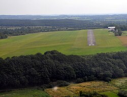
The St. Michaelisdonn airfield ( ICAO code : EDXM ) is a commercial airfield near Sankt Michaelisdonn in the Dithmarschen district in Schleswig-Holstein . It is colloquially called Hopen airfield after the nearby district . The operator is the Dithmarscher Luftsportverein .
location
The airfield is located above the marshland on the Klevücken at an altitude of 38 m AMSL , about 2 km southeast of Sankt Michaelisdonn and about 1 km north of Dingerdonn . The march runs north of the square . In the west, the airfield borders on the Kleve nature reserve , in the south there is a campsite, and directly north of the local golf course.
Infrastructure
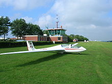
The airfield has a 700 m long, 18 m wide asphalt runway oriented 07/25. To the north of it runs parallel a 1000 m long towing track for the winch launch , which also serves as a runway for gliders. By the firing of runway and landing threshold (RL / Thr) is night flights possible. A VDF direction finder (see QDM ) is available as a navigation aid. A gas station with AvGas 100 LL and Jet A-1 is also available.
In addition to the hangar and tower, there is also the Fliegerklause restaurant , as well as the clubhouse and the flying school of the Dithmarscher Luftsportverein.
Flight operations

Today the airfield is mainly used for general aviation , scheduled flights no longer take place. The main user is the local air sports club , but the infrastructure is designed to also handle commercial flights. The approval applies to airplanes , helicopters , motor gliders , gliders and ultralight aircraft up to 5.7 t.
As a commercial airfield, the airfield is subject to operational obligations : In summer, it is open from 10 a.m. local time until sunset (but no later than 7.30 p.m.). In winter, it closes at 4 p.m. on weekdays. Prior registration is required for take-offs and landings outside the regular opening times ( PPR ). In the aeronautical radio the name of the place is abbreviated, the official call sign of the flight control is therefore Sankt Michel Info .
Air sports club
The Dithmarscher Luftsportverein e. V. (DLV) is the operator and the sole owner of the airfield since 1997. He does air sports with light aircraft and gliders .
history
Even before the Second World War there was a glider airfield in Sankt Michaelisdonn, which was initially used for agriculture after the end of the war. Though flying was banned in Germany after the war, was in 1950 in Heide of saving Club Meise founded, whose aim was to raise money for the reconstruction of the site and the purchase of aircraft. On October 13, 1952, the club , which had since been renamed Dithmarscher Luftsportverein , was able to carry out the first rubber rope starts on the Hopener site with an SG 38 . Around 1956 the space was enlarged so that it could also be used for winch starts and motorized flight, which has since been approved again. In 1958 a new hangar was built.
In 1960 the Dithmarschen district expanded the area to an area of 54 hectares . On March 1st of the same year, the previous glider airfield was approved as a "public landing site" and the St. Michaelisdonn flight school opened. In addition to runway 08/26, a 525 m long cross runway (14/32) was later set up. In 1965 the airfield had 31,000 flight movements .
From 1967 Michaelisdonn was regularly served by the airlines General Air and West Coast Flight. The destinations were Büsum , Sankt Peter-Ording , Wyk , Pellworm , Westerland and Helgoland .

In the 1970s, the main runway - at that time still called 08/26 - was paved and the clubhouse was built.
In 1997, the district decided to dissolve the previous airport operating company . The airfield was reduced to an area of 30 hectares and has since been the sole property of the air sports club.
See also
Web links
- dithmarscher-luftsportverein.de - Official website of the operator
Individual evidence
- ↑ a b c d coordinates EDXM. In: dithmarscher-luftsportverein.de. Dithmarscher Luftsportverein, accessed on July 25, 2011 (airfield information).
- ↑ a b c d Dithmarscher Luftsportverein eV - 1950 - 2008. In: dithmarscher-luftsportverein.de. Dithmarscher Luftsportverein, accessed on July 26, 2011 .
- ↑ ICAO (Ed.): Doc 7910: Location Indicators . No. 133 , 2009, ISBN 978-92-9231-383-8 , ISSN 1727-2610 .
- ↑ Hopen. In: st-michaelisdonn.de. Sankt Michaelisdonn parish, accessed on July 26, 2011 (information about the Hopen district).
- ↑ a b c d EDXM - St. Michaelisdonn airfield. In: dithmarscher-luftsportverein.de. Dithmarscher Luftsportverein, accessed on July 26, 2011 .
- ↑ Learn to fly in the DLV. In: dithmarscher-luftsportverein.de. Dithmarscher Luftsportverein, accessed on July 26, 2011 .
- ↑ Welcome to the DLV. In: dithmarscher-luftsportverein.de. Dithmarscher Luftsportverein, accessed on July 26, 2011 .
- ↑ a b c d e f History of the St. Michaelisdonn airfield. In: dithmarscher-luftsportverein.de. Dithmarscher Luftsportverein, accessed on July 26, 2011 .

