Frauenkogel (Gösting)
| Frauenkogel | ||
|---|---|---|
|
Frauenkogel above the Thaler Graben from the northeast (Gösting castle ruins) |
||
| height | 561 m above sea level A. | |
| location | Styria , Austria | |
| Mountains | Grazer Bergland , Lavanttal Alps | |
| Dominance | 0.47 km → Höhenberg | |
| Notch height | 32 m ↓ Reckersattel | |
| Coordinates | 47 ° 5 '32 " N , 15 ° 22' 15" E | |
|
|
||
| rock | Limes , dolomites | |
| Age of the rock | Paleozoic | |
| particularities | Remains of a medieval refugee castle | |
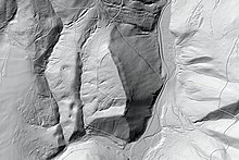
The Frauenkogel (also called Frauenberg ) is 561 m above sea level. A. high hill in the western part of the Grazer Bergland in the Austrian state of Styria . The survey is located in the northwest of the provincial capital Graz . On the western slope are the listed remains of an early medieval refugee castle .
Location and surroundings
The Frauenkogel rises in the Graz district of Gösting on the left about 150 m above the Thaler Graben . It forms a southern branch of the Steinkogel range. In the west, the Frauenkogel is separated from the Thaler basin with the village of Oberbichl by two ditches running southwards . On the south side , the Winkelbach breaks through the ridge in the Fuchsloch, separates the Frauenkogel from the Madersberg and forms the city limits. To distinguish it from the Frauenkogel , which is only 2.3 km north-west near Straßengel , the hill is also referred to by the local population as the Frauenberg . It is part of the protected landscape area of the western mountain and hill country of Graz (LSG-39).
Geology and geomorphology
The Frauenkogel belongs to the Graz Paleozoic and consists of the so-called Barrande layers, a series of dark, fossil-rich bank limestone . The lying is formed by light and dark gray dolomites . On the west side, large areas of Pleistocene loess loam come to the surface. All the way down to Madersberg there are even, dark clay slate inclusions, which is why the literature also speaks of clayey Choneten limestone slates. The blue-gray to yellowish tinted, lightly weathered limestones are characterized by a conodont fauna of the Lower Carboniferous . Subordinate intercalations of thin, pale yellowish, platy breaking Lydite and greenish slate occur.
Rampart
Remains of an early medieval ramparts have been preserved on the Frauenkogel . Finds of a fire hitting iron, a spur fragment and some ceramic fragments allow a temporal classification in the 10th century. The building is therefore associated with the Magyar Wars and probably served as a refuge for the women and children of the rural population . Diether Kramer sees the complex as an Ottonian predecessor of the nearby Gösting Castle .
In 1966 the Fliehburg was first described in detail by Rudolf Flucher. The more than 500 m long wall, which can still be seen in rudiments, is adapted to the shape of the mountain's soil and roughly shows the shape of a trapezoid . While the baseline runs along the ridge, there is an artificial water hole at the apex where the rainwater collects. In addition to small trenches, there are numerous boulders that have slipped from the crest of the wall , which - according to analyzes by the Montan University Leoben - were connected with lime mortar .
Literature and maps
- Franz Angel : The chonet slate from the Frauenkogel near Gösting. In: Festschrift for the 70th birthday of Prof. Dr. F. Angel. Natural science associations for Styria and Carinthia, Graz 1956, pp. 69–73.
- Walter Brunner : Thal. The habitat and its inhabitants. Verlag Josef Riegler, Hausmannstätten 1994, pp. 24-27.
- Rudolf Flucher: The escape castle on the Frauenberg near Gösting. In: Blätter für Heimatkunde , Volume 40, Graz 1966, pp. 56–59.
- Rudolf Flucher: Lost weir systems around Graz - The Frauenberg near Gösting. In: Historisches Jahrbuch der Stadt Graz , Volume 7/8, Graz 1975, pp. 245–246.
- City map Graz 1: 15,000. Freytag & Berndt , Vienna 2017, ISBN 978-3850841146 .
- Austrian map 1: 50,000, sheet 4229 ( UTM ). Federal Office for Metrology and Surveying .
Web links
Individual evidence
- ↑ a b c Rudolf Flucher: The refuge at Fraunberg at Gösting. In: Blätter für Heimatkunde , Volume 40, Graz 1966, pp. 56–59.
- ↑ Landscape protection area No. 29. (PDF) State of Styria , accessed on July 8, 2019 .
- ↑ Digital Atlas of Styria: Geology & Geotechnics. State of Styria , accessed on July 15, 2019 .
- ↑ Helmut wing : The geology of the Grazer Bergland. In: Communications from the Department of Geology, Paleontology and Mining at the Landesmuseum Joanneum , Graz 1975, pp. 47–48. Online PDF , accessed July 15, 2019.
- ↑ Helmut Flügel, p. 76.
- ↑ Christoph Gutjahr: Archaeological sources of Styria from the Carolingian and Ottonian times - early Middle Ages. In: Research on the historical regional studies of Styria , Volume 70, Historical Provincial Commission for Styria, Graz 2012, pp. 94–95.
- ^ Walter Brunner : Thal. The habitat and its inhabitants. Verlag Josef Riegler, Hausmannstätten 1994, pp. 24-27.
- ↑ Diether Kramer : The city of Graz from the point of view of archeology. In: Walter Brunner (ed.): History of the City of Graz, Volume I: Living space - City - Administration. Graz 2003, pp. 17-60.


