Gams (Frohnleiten community)
|
Gams ( village ) locality cadastral community Gams |
||
|---|---|---|
|
|
||
| Basic data | ||
| Pole. District , state | Graz-Umgebung (GU), Styria | |
| Judicial district | Graz-West | |
| Pole. local community | Frohnleiten | |
| Coordinates | 47 ° 16 ′ 41 ″ N , 15 ° 17 ′ 5 ″ E | |
| height | 485 m above sea level A. | |
| Residents of the village | 170 (January 1, 2020) | |
| Area d. KG | 36.47 km² | |
| Post Code | 8130 Frohnleiten | |
| Statistical identification | ||
| Locality code | 15012 | |
| Cadastral parish number | 63005 | |
| Counting district / district | Rothleiten area (60663 X [009]) | |
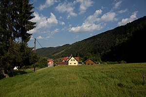
 View of the village of Gams near Frohnleiten |
||
| Source: STAT : index of places ; BEV : GEONAM ; GIS-Stmk | ||
The Gams is a village in the area of the cadastral municipality of the same name in the municipality of Frohnleiten in the Austrian state of Styria . The Gams has 170 residents on an area of 3647.20 hectares, and the Gamsbach also flows through the village.
Most of the area consists of forests, most of which belong to the Baron Family Goëss-Saurau , who live in Frohnleiten . Gravel roads lead from the fork in the Gams to the Ratlosgraben , Pöllagraben and Schenkenberg . The Gams is four and a half kilometers from the center of Frohnleiten.
population
The table shows the population change in Gams.
| Locality | 05/15/2001 | October 31, 2011 | 01/01/2015 |
|---|---|---|---|
| Chamois | 277 | 269 | 284 |
literature
- Othmar Pickl: 700 years of the market town of Frohnleiten. Market town of Frohnleiten, 1996
