
Adriach (Frohnleiten municipality)
|
Adriach ( village ) locality cadastral municipality Adriach |
|||
|---|---|---|---|
|
|||
| Basic data | |||
| Pole. District , state | Graz-Umgebung (GU), Styria | ||
| Judicial district | Graz-West | ||
| Pole. local community | Frohnleiten | ||
| Coordinates | 47 ° 15 '59 " N , 15 ° 18' 25" E | ||
| height | 468 m above sea level A. | ||
| Residents of the village | 369 (January 1, 2020) | ||
| Building status | 125 (2011 ) | ||
| Area d. KG | 13.51 km² | ||
| Postcodes | 8121, 8130 Frohnleiten | ||
| Statistical identification | |||
| Locality code | 15011 | ||
| Cadastral parish number | 63001 | ||
| Counting district / district | Rothleiten-Laufnitzdorf-Adriach, Rothleiten area (60663 X [008,009]) | ||
 View of Adriach |
|||
| Source: STAT : index of places ; BEV : GEONAM ; GIS-Stmk | |||

Adriach is a village in the area of the cadastral municipality of the same name in the municipality of Frohnleiten in the Austrian state of Styria . Adriach has 369 inhabitants on an area of 1,351.43 hectares. The Adriachbach and the Heumanngraben are located in the village . Adriach is two kilometers from the center of Frohnleiten.
geography
The Mur flows through the area of the cadastral community. A headrace channel leads from Adriach-Rabenstein through the Kugelstein to Eichberg near Peggau . Here an inlet channel leads to the Peggau power plant . The rest of the water flows directly back into the Mur. Other streams and ditches in Adriach are the Adriachbach , the Forstbach , the Heumanngraben and the Pfenningtalgraben . The Haneggkogel ( 1088 m above sea level ), a popular hiking destination, is partly located in the Adriach area. The next higher mountain is the Parmaseggkogel ( 785 m ). In Adriach there are several large, partly well-known manors such as Hoyer , Jöller , Bodlos and Poldlwirt . These courtyards are important waypoints for hikers. The southern railway line runs at the southern tip of Adriach . This leads over the newly built Kugelstein Bridge and through the Kugelstein Tunnel .
Localities
In the cadastral Adriach next to the same place and lie rotting Adriach-Rabenstein and the scattered settlement Adriach-Reising .
Buildings
One of the oldest churches in Styria, the St. George's Church, is located in Adriach . The church was built at the beginning of the 11th century by Count Markwart IV and is currently looked after by the Frohnleitner parish.
Furthermore, the baroque Rabenstein Castle is in the cadastral community. The rock castle was built in the 14th century as the residence of the lord of the castle von Rammenstein. The castle was owned by the STEG and is now privately owned. Theatrical performances and music events often took place here.
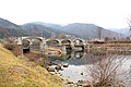
In Adriach there is an old Roman bridge , probably built in the 2nd or 3rd century. The Roman road from Liezen to Flavia Solva led over the bridge . The foundation walls of an old fortification from the 2nd century are located near the bridge, northwest of the Kugelstein .
Infrastructure facilities
The Rabenstein run-of- river power plant is located in Adriach , near Rabenstein Castle. The power plant was put into operation in 1987, its output is 13.9 MW. An old headrace channel is currently in operation, which was built from 1906 to 1908 and directs a large part of the Mur water to the Peggau power plant . The old Adriach power plant is no longer in operation. The weir system of the power plant, however, has been preserved.
In Adriach the sewage treatment plant of the municipality of Frohnleiten was built in the 1980s . The sewage treatment plant, located right next to the Mur, was opened in 1987. The municipality has been running the facility ever since.
The Murhof Golf Club is idyllically located in the Adriach area on the Mur with a view of Rabenstein Castle. The renowned golf course offers 18 holes as well as a first-class hotel with a restaurant.
The cemetery and the old people's home of the municipality of Frohnleiten are also located in Adriach .
population
The table shows the population change in Adriach.
| Locality | 05/15/2001 | October 31, 2011 | 01/01/2015 |
|---|---|---|---|
| Adriach | 413 | 374 | 399 |
photos

Church of Adriach

View from Rabenstein Castle

The Roman Bridge in Adriach

Murstollen through the Kugelstein
Weir system of the old Adriach power station


literature
- Othmar Pickl: 700 years of the market town of Frohnleiten. Market town of Frohnleiten, 1996
Individual evidence
- ↑ http://www.bergfex.at/sommer/steiermark/touren/wanderung/38061,gmoa-alm-und-haneggkogel/
- ↑ Serenade sounds at Rabenstein Castle , steiermark.orf.at, June 7, 2016
- ^ Rabenstein run-of-river power station , Verbund
- ↑ http://www.murhof.at/
- ↑ http://www.statistik.at/blickgem/vz2/g60610.pdf
- ↑ http://www.statistik.at/blickgem/rg3/g60610.pdf
Cadastral communities: Adriach | Frohnleiten | Chamois | Gamsgraben | Gschwendt | Court Office | Lasa | Laufnitzdorf | Laufnitzgraben | Mauritzen | Pfannberg | Röthelstein | Rothleiten | Schrems | Wannersdorf
Locations: Adriach | Badl | Brunnhof | Frohnleiten | Chamois | Gamsgraben | Gschwendt | Court Office | Lasa | Laufnitzdorf | Laufnitzgraben | Lieutenant Günther-Siedlung | Maria Ebenort | Peugen | Pfannberg | Rothleiten | Röthelstein | Schönau | Schrauding | Schrems | Swiss factory | Ungersdorf | Wannersdorf
City: Frohnleiten | Villages: Adriach • Laufnitzdorf • Röthelstein • Schrems • Ungersdorf | Rotten: Adriach-Rabenstein • Am Anger • Badl • Gams • Hammerl • Peugen • Rothleiten • Schrauding • Schweizerfabrik • Wannersdorf • Weyer | Settlements: Brunnhof • Lieutenant Günther settlement • Maria Ebenort • Rieglmoarschweig • Schönau • Wiesersiedlung • Winkler | Scattered houses: Adriach-Reising • Altenberg • Arzwaldgraben • Dürnberg • Gamsgraben • Gschwendt • Hofamt • Laas • Laufnitzberg • Laufnitzgraben Neustadt Pfannberg • Pöllagraben • Ratlosgraben • Schenkenberg • Talgraben • Winterleiten | Other local documents: Ruin Old-Pfannberg • Bauerfeind paper mill • hunting lodge Hochalm • Castle Pfannberg • Castle Rabenstein • Schloss Weyer
Counting district: Frohnleiten Center | Villa district suburb | Mauritzen - Brunnhof | Schönau - Swiss factory | Wannersdorf | Frohnleiten-Süd | Residential complex Am Kogl | Living room At the Grünanger | Röthelstein | Rothl. - Laufnitzdf - Adriach | Rothleiten surroundings | Schrems near Frohnleiten
Former communities: Mauritzen 1850–1952 | Rothleiten 1850–1952 | Schrems 1850–2014 | Röthelstein 1850–2014 |