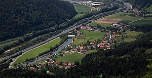
Laufnitzdorf
|
Laufnitzdorf ( village ) locality cadastral community Laufnitzdorf |
||
|---|---|---|
|
|
||
| Basic data | ||
| Pole. District , state | Graz-Umgebung (GU), Styria | |
| Judicial district | Graz-West | |
| Pole. local community | Frohnleiten | |
| Coordinates | 47 ° 17 '28 " N , 15 ° 19' 13" E | |
| height | 434 m above sea level A. | |
| Residents of the village | 304 (January 1, 2020) | |
| Area d. KG | 8.13 km² | |
| Post Code | 8130 Frohnleiten | |
| Statistical identification | ||
| Locality code | 15015 | |
| Cadastral parish number | 63014 | |
| Counting district / district | Rothleiten-Laufnitzdorf-Adriach (60663 X [008]) | |
 Place view |
||
| Source: STAT : index of places ; BEV : GEONAM ; GIS-Stmk | ||
Laufnitzdorf is a village in the area of the cadastral municipality of the same name in the municipality of Frohnleiten in the Austrian state of Styria . Laufnitzdorf has 304 residents (as of January 1, 2020) on an area of 812.97 hectares, the Laufnitzbach also flows through the village.
The craft beer brewery "Flecks Bier" has its headquarters in the village. The Laufnitzdorf hydropower plant is also located in the cadastral community. Laufnitzdorf is connected to the Brucker Schnellstraße S35 with the semi-junction "Laufnitzdorf". The state road L121 runs through the local area . Laufnitzdorf is four kilometers from the center of Frohnleiten.
population
The table shows the population change in the town of Laufnitzdorf.
| Locality | 05/15/2001 | October 31, 2011 | 01/01/2015 |
|---|---|---|---|
| Laufnitzdorf | 320 | 316 | 323 |
literature
- Othmar Pickl: 700 years of the market town of Frohnleiten. Market town of Frohnleiten, 1996
Individual evidence
- ↑ Statistics Austria: Population on January 1st, 2020 by locality (area status on January 1st, 2020) , ( CSV )
- ↑ http://www.kleinezeitung.at/steiermark/graz/5056583/Steirer-des-Tages_Diese-Bierbrauer-kommen-so-richtig-vom-Fleck
- ↑ http://www.statistik.at/blickgem/vz2/g60610.pdf
- ↑ http://www.statistik.at/blickgem/rg3/g60610.pdf
