
Garden city / city pasture
|
Garden city / city pasture
City of Rostock
Coordinates: 54 ° 5 ′ 12 ″ N , 12 ° 4 ′ 58 ″ E
|
|
|---|---|
| Height : | 35 m above sea level NN |
| Area : | 4.8 km² |
| Residents : | 3312 (Dec. 31, 2017) |
| Population density : | 690 inhabitants / km² |
| Postcodes : | 18057, 18059 |
| Area code : | 0381 |
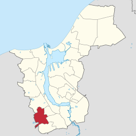  Location of Gartenstadt / Stadtweide in Rostock
|
|
Gartenstadt / Stadtweide is a district of the Hanseatic city of Rostock , which is located on the southwestern outskirts. It includes the actual garden city , a district built since around 1920, and the Stadtweide residential area . In the garden city there are settlements (mostly one and two-family houses), tennis and other sports facilities as well as large parts of the Barnstorf Forest with the Rostock Zoo , the Westfriedhof, the Christophorus School , as well as the astronomical station "Tycho Brahe" and an employment agency . The new cemetery and the Rostock telecommunications tower of Deutsche Telekom AG are located in the Stadtweide residential area, which is part of the garden city . The sports forum with the Ostseestadion and the Neptun swimming pool is adjacent to the garden city . The youngest residential area in this district is the residential and sports park on Tannenweg.
history

The first houses in the garden city were built at the end of the 1910s in the area between Trotzenburger Weg, Am Waldessaum, Asternweg and the western part of Kopernikusstraße. This is why this area is also known as the “Old Garden City”. In addition to the traditional architecture, the then new Bauhaus style was used for the first time in individual houses . The development of this area was completed around 1960 and then further expansion in a westerly direction began. After extensive tree clearing, the streets Waldmeisterweg, Tulpenweg, Primelweg and the northwestern part of the Nelkenweg were created. The development in this area initially came to an end at the end of the 1970s with the houses in the southeastern Nelkenweg between Waldmeisterweg and Am Waldessaum, as did the last gaps in what was then the entire garden city. All other areas, such as Stadtweide, the residential area on Tannenweg and the area around the New Cemetery were administratively included in the garden city from the beginning of the 1990s. Until then, this area represented the district of Stadtweide, which belonged to the Südstadt district.
Web links
Individual evidence

Biestow | Brinckmansdorf | Diedrichshagen | Dierkow-Neu | Dierkow-Ost | Dierkow-West | Evershagen | Garden city / city pasture | Gehlsdorf | Big small | Hansaviertel | Hinrichsdorf | Hinrichshagen | High dune | Jürgeshof | Kröpeliner-Tor-Vorstadt | Krummendorf | Lichtenhagen | Lütten Klein | Markgrafenheide | Nienhagen | Peez | Reutershagen | Schmarl | City center | Stuthof | Südstadt | Toitenwinkel | Peat bridge | Warnemünde | Wiethagen .