Gilserberg (district)
|
Gilserberg
community Gilserberg
Coordinates: 50 ° 57 ′ 9 ″ N , 9 ° 3 ′ 44 ″ E
|
|
|---|---|
| Height : | 338 m above sea level NN |
| Area : | 9.22 km² |
| Residents : | 923 (June 30, 2016) |
| Population density : | 100 inhabitants / km² |
| Postal code : | 34630 |
| Area code : | 06696 |
Gilserberg is the largest district and the seat of the administration of the Gilserberg community of the same name in the Schwalm-Eder district in northern Hesse .
Geographical location
The place is on the upper reaches of the Gilsa in the center of the Gilserberg highlands , a plateau in the northern part of the Upper Hessian threshold . In Gilserberg the federal road 3 Kassel - Marburg and the state road 3155 Schwalmstadt - Gemünden intersect . Schwalmstadt is about 10 km to the south-east, Marburg is about 30 km to the south-west. The intersection of the two streets marks the southernmost point of the Kellerwald-Edersee Nature Park .
history
Gilserberg was first mentioned in a document in 1261 as Willingeshusen . Until about 1400 the place was called Willingeshusen vor dem Walde or Klein-Willingeshusen , after which it was only called Willingeshusen until about 1700 . The place name Gilserberg has only been used since the 18th century.
On the north-western outskirts there was a station of the Kellerwaldbahn , opened in 1911 , on which passenger traffic in 1972 and goods traffic in the winter of 1980/81 were suspended. In the course of the Hessian territorial reform between 1972 and 1974 ten surrounding villages were united in the newly formed community of Gilserberg.
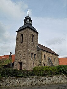
Gilserberg has been part of the Evangelical parish of Sebbeterode since the 16th century . Today's church, located in the center of the village, was built between 1706 and 1709. There has also been a Catholic church since 1949.
Until the 1930s there was a Jewish community in Gilserberg , which around 1900 had over 70 members and made up about 15% of the local population.
In 2012 Gilserberg celebrated its 750th anniversary.
Territorial reform
On December 31, 1971, as part of the regional reform in Hesse, the previously independent communities Gilserberg, Heimbach , Lischeid , Sachsenhausen , Schönau and Winterscheid merged to form the new community Gilserberg. Due to its central location in the Gilserberg highlands, Gilserberg became the seat of administration and namesake of the new community. On April 1, 1972, Appenhain and Itzenhain were added with Bellnhausen , which was incorporated in 1928 . After these mergers took place voluntarily, Moischeid , Sebbeterode and Schönstein were incorporated by state law on January 1, 1974 .
Web links
- The districts on the website of the community of Gilserberg
- Gilserberg, Schwalm-Eder district. Historical local dictionary for Hessen. In: Landesgeschichtliches Informationssystem Hessen (LAGIS).
- Literature on Gilserberg in the Hessian Bibliography
Individual evidence
- ↑ a b Gilserberg, Schwalm-Eder district. Historical local dictionary for Hessen. In: Landesgeschichtliches Informationssystem Hessen (LAGIS).
- ↑ Gilserberg - data and facts. Population numbers. BVB-Verlagsgesellschaft mbH, 2016, accessed on May 3, 2018 .
- ^ Gilserberg with the Winterscheid district (Schwalm-Eder district). Alemannia Judaica , accessed January 25, 2016 .
- ↑ Law on the reorganization of the districts Fritzlar-Homberg, Melsungen and Ziegenhain (GVBl. II 330-22) of September 28, 1973 . In: The Hessian Minister of the Interior (ed.): Law and Ordinance Gazette for the State of Hesse . 1973 No. 25 , p. 356 , § 1 ( online at the information system of the Hessian state parliament [PDF; 2,3 MB ]).
- ^ Federal Statistical Office (ed.): Historical municipality directory for the Federal Republic of Germany. Name, border and key number changes in municipalities, counties and administrative districts from May 27, 1970 to December 31, 1982 . W. Kohlhammer, Stuttgart / Mainz 1983, ISBN 3-17-003263-1 , p. 411 f .

