
Żagań (rural municipality)
| Gmina Żagań | |||
|---|---|---|---|

|
|
||
| Basic data | |||
| State : | Poland | ||
| Voivodeship : | Lebus | ||
| Powiat : | Żagań | ||
| Geographic location : | 51 ° 37 ' N , 15 ° 21' E | ||
| Residents : | see Gmina | ||
| Telephone code : | (+48) 68 | ||
| License plate : | FZG | ||
| Economy and Transport | |||
| Street : | Zielona Góra - Jelenia Góra | ||
| Rail route : | Łódź – Forest (–Cottbus) | ||
| Berlin – Breslau | |||
| Next international airport : | Wroclaw | ||
| Poznan-Ławica | |||
| Gmina | |||
| Gminatype: | Rural community | ||
| Surface: | 281.11 km² | ||
| Residents: | 7324 (June 30, 2019) |
||
| Population density : | 26 inhabitants / km² | ||
| Community number ( GUS ): | 0810092 | ||
| Administration (as of 2016) | |||
| Wójt : | Tomasz Niesłuchowsk | ||
| Address: | ul.Armii Krajowej 9 68-100 Żagań |
||
| Website : | www.gminazagan.pl | ||

The Gmina Żagań [ ˈɡmina ˈʒagaɲ ] is a rural community (gmina wiejska) in the powiat Żagań of the Lubusz Voivodeship in Poland . The administrative seat of the municipality is the eponymous city Żagań ( German Sagan ), which does not belong to the municipality.
With 281.1 km² the municipality takes up almost a quarter of the district (24.8%), but with about 7300 inhabitants it does not even have a tenth of its population.
geography

Żagań and the surrounding villages are located in the north of the historical Lower Silesia region . The Gmina Żagań is located in the center of the powiat Żagań and extends in a y-shape at its northern and southern borders. It encloses the district town Żagań in the north, east and south. The Queis , which comes from the south-west, flows into the Bober , which flows to the north-west, on the east- south- east border with Osiecznica .
Surrounding municipalities are Nowogród Bobrzański in the north, Brzeźnica in the northeast, Szprotawa and Małomice in the east, Osiecznica in the south, Iłowa , the city Żagań and the rural municipality Żary in the west.
Most of the settlements in the municipality are to the north and east of the city, while the south is characterized by the Saganer Forest, part of the Lower Silesian Heath , through which the A18 autostrada runs.
structure
The community consists of 15 school offices , German names in brackets:
- Bożnów (Eckersdorf)
- Bukowina Bobrzańska (Buchwald b. Sagan)
- Chrobrów (Petersdorf)
- Dzietrzychowice (Dittersbach) with Marysin (Marienthal)
- Gorzupia (Gladisgorpe) with Dybów (Diebau) and Gorzupia Dolna (Nieder Gorpe)
- Jelenin (Hirschfeldau)
- Łozy (Loos)
- Miodnica (Mednitz) with Gryżyce (Greisitz)
- Nieradza (Charlottenthal) with Kocin (Klein Kothau)
- Pożarów (Brennstadt)
- Rudawica (Eisenberg) with Pruszków (Kaltdorf) and Puszczyków
- Stara Kopernia (Küpper)
- Stary Żagań (Altkirch , formerly Alt Sagan)
- Tomaszowo
- Trzebów (Tschiebsdorf) with Dobre nad Kwisą (Dober break)
history
When Poland moved to the west after the Second World War , the region became Polish territory. On June 28, 1946, the municipality Dzietrzychowice was assigned as part of the Powiat Żagań of the newly created Wroclaw Voivodeship and in 1950 the Grünberg Voivodeship .
From July 1, 1952, the municipality consisted of 11 districts : Bukowina Bobrzańska, Chrobrów, Dzietrzychowice, Jabłonów, Jelenin, Kącik, Kocin, Marysin, Pożarów, Stara Kopernia and Stary Żagań. As a result of the abolition of the municipalities, it was dissolved in 1954. When the parishes were reintroduced, the Dzietrzychowice parish was not reestablished in 1972; instead, most of the places came to the newly formed Gmina Żagań, Jabłonów (Schönbrunn) came to the Brzeźnica parish .
Photo impressions

Castle of the estate in Dybów

Tower in Dzietrzychowice
Church in Gorzupia Dolna
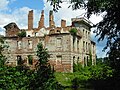
Ruins of the castle in Jelenin

Epitaphs on the church in Miodnica

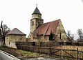
Church in Stary Żagań


Web links
Footnotes
- ↑ population. Size and Structure by Territorial Division. As of June 30, 2019. Główny Urząd Statystyczny (GUS) (PDF files; 0.99 MiB), accessed December 24, 2019 .
- ^ Sołectwa. Urząd Gminy Żagań, September 23, 2016, accessed February 27, 2017 (Polish).
- ↑ Wykaz Gromad Polskiej Rzeczypospolitej Ludowej według stanu z dnia 1.VII 1952 r., PRL, CIS, Warszawa
