
Żary (rural community)
| Gmina Żary | |||
|---|---|---|---|

|
|
||
| Basic data | |||
| State : | Poland | ||
| Voivodeship : | Lebus | ||
| Powiat : | Żary | ||
| Geographic location : | 51 ° 40 ′ N , 15 ° 8 ′ E | ||
| Residents : | see Gmina | ||
| Telephone code : | (+48) 68 | ||
| License plate : | FZA | ||
| Economy and Transport | |||
| Street : | Autostrada A18 | ||
| Droga krajowa 12 | |||
| Droga krajowa 27 | |||
| Rail route : | Łódź – Forst (Lausitz) –Cottbus | ||
| Zielona Góra – Żary | |||
| Next international airport : | Wroclaw | ||
| Poznan-Ławica | |||
| Gmina | |||
| Gminatype: | Rural community | ||
| Surface: | 294.43 km² | ||
| Residents: | 12,343 (Jun. 30, 2019) |
||
| Population density : | 42 inhabitants / km² | ||
| Community number ( GUS ): | 0811102 | ||
| Administration (as of 2015) | |||
| Wójt : | Leszek Mrożek | ||
| Address: | Al. Jana Pawła II 6 68-200 Żary |
||
| Website : | www.gminazary.pl | ||

The gmina wiejska Żary [ ˈɡmina ˈʐarɨ ] is a rural community in the powiat Żary of the Lubusz Voivodeship in Poland . The municipality has its seat in the eponymous city Żary ( German Sorau ), which does not belong to the municipality.
With an area of 294.43 km² it is one of the larger municipalities in the voivodeship and takes up a good fifth of the district (21.14%), but with 12,343 inhabitants (as of June 30, 2019) it is rather sparsely populated (42 inhabitants / km²).
geography
location

Żary and most of the localities of the municipality surrounding the city are located in the southeast of the historic Niederlausitz region on the Lower Silesian border. On the railway line between the towns of Żary and Żagań lies the Jaszkowice desert (Jeschkendorf) , where a border church for Protestant Silesians stood from 1668 to 1709 .
The municipality is located in the east of the powiat and completely encloses the district town of Żary, albeit only with a narrow strip in the southeast. The Lubsza ( Lubst or Lubis ) tributary of the Neisse rises to the west of the city with several source rivers in the municipality near Olbrachtów . To the south of the city center lies the 227 meter high ridge mountain ( Góra Żarska in Polish ), surrounded by Olbrachtów in the west and Łaz in the south and the Kunice district in the east.
Surrounding communities are Nowogród Bobrzański (Powiat Zielona Góra) in the north, in the powiat Żagań the rural community Żagań and the city Żagań in the east, Iłowa in the southeast and Wymiarki in the south, as well as in the powiat Żary Przewóz in the southwest, Lipinki Łużyckie in the west and Jasień in the west .
Infrastructure

By the municipality running Droga krajowa 12 (DK12), Droga krajowa 27 (DK27) and Droga wojewódzka 287 (DW287) star-shaped city Żary to. This is connected to the A18 autostrada (part of European route 36 ), which runs through the southwest of the municipality, via the DK27 coming from the German-Polish border crossing Podrosche- Przewóz . Junction 25 Żary is located between Drozdów and Rusocice .
The Sieniawa Żarska station is on the Łódź – Forst (Lausitz) ( –Cottbus ) railway . Railway stations in Lubanice and Bieniów are located on the Zielona Góra – Żary line that branches off from this line . At the latter station, the Wrocław – Gubinek – Berlin line crosses through Żagań .
structure
The community consists of 24 Schulzenämter , German names up to 1945 in brackets:

Church in Biedrzychowice Dolne

Church in Bieniów

Church in Bogumiłów

Church in Drożków
Chapel in Lubomyśl

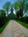
St. Barbara Church in Mirostowice Dolne
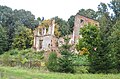
Ruins of Nißmenau Palace in Włostów

Church ruins of St. John in Złotnik


.jpg)

.jpg)

- Biedrzychowice Dolne (Friedersdorf)
- Bieniów (Benau)
- Bogumiłów - Janików (Reichenau, Jenkendorf)
- Drozdów - Rusocice (Ziebern, Raußen)
- Drożków (Droskau)
- Grabik (Grabig)
- Kadłubia (Goldbach)
- Lubanice (Laubnitz)
- Lubomyśl (Waltersdorf)
- Łaz (Lohs)
- Łukawy (Hermsdorf)
- Marszów (Marsdorf)
- Miłowice (Mildenau)
- Mirostowice Dolne (Nieder Ullersdorf)
- Mirostowice Górne (Upper Ullersdorf)
- Olbrachtów (Albrechtsdorf)
- Olszyniec (Wellersdorf)
- Rościce (Ruppendorf)
- Sieniawa Żarska (Schönwalde)
- Siodło (Zedel)
- Stawnik (Teichdorf)
- Surowa (Syrau)
- Włostów - Dąbrowiec (Nißmenau , Königsdubrau)
- Złotnik (Reinswalde)
history
When Poland moved to the west after the Second World War , the region became Polish territory. On June 28, 1946, the communities Kadłubia and Olbrachtów were assigned as part of the Żary district of the newly created Wroclaw Voivodeship and in 1950 the Grünberg Voivodeship .
As a result of the structural reform in Poland, the municipalities were dissolved in 1954. With the reintroduction of the municipalities in 1973, most of the former church Kadłubia were about two-thirds of the former municipality Olbrachtów and three former to Zabłocie joined forces belonging places to the rural community of Żary, the south-east location of the city location Kunice (Kunz village) , however, was in the city incorporated.
Sources and further references
Footnotes
- ↑ population. Size and Structure by Territorial Division. As of June 30, 2019. Główny Urząd Statystyczny (GUS) (PDF files; 0.99 MiB), accessed December 24, 2019 .
- ↑ Władze. In: website of the municipality. April 22, 2018, Retrieved September 8, 2019 (Polish).
- ^ Johann Gottlob Worbs : About the border churches in Upper and Lower Lusatia, in Crossenschen and Züllichauschen, in which the Silesians deprived of their own religious practice could continue their worship . In: New Lusatian Magazine . tape 11 , 1833, pp. 481–485, here: 483 ( online in the Google book search).
- ^ Sołectwa Gminy Żary. In: website of the municipality. April 22, 2018, Retrieved September 8, 2019 (Polish).
