Gmina Chrzanów
| Gmina Chrzanów | ||
|---|---|---|

|
|
|
| Basic data | ||
| State : | Poland | |
| Voivodeship : | Lesser Poland | |
| Powiat : | Chrzanów | |
| Geographic location : | 50 ° 9 ' N , 19 ° 24' E | |
| Residents : | s. Gmina | |
| Postal code : | 32-500 to 32-503 | |
| Telephone code : | (+48) 32 | |
| License plate : | KCH | |
| Economy and Transport | ||
| Street : | A4 | |
| Droga krajowa 79 | ||
| Rail route : | Trzebinia – Oświęcim | |
| Next international airport : | Krakow-Balice | |
| Gmina | ||
| Gminatype: | Urban-and-rural parish | |
| Gmina structure: | 6 school offices | |
| Residents: | 46,929 (Jun. 30, 2019) |
|
| Community number ( GUS ): | 1203033 | |
| Administration (as of 2012) | ||
| Mayor : | Ryszard Kosowski | |
| Address: | al. Henryka 20 32-500 Chrzanów |
|
| Website : | www.chrzanow.pl | |
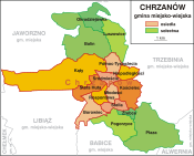
The Gmina Chrzanów ( , ˈxʃanuf ) is an urban-and-rural municipality in the powiat Chrzanów of the Lesser Poland Voivodeship in Poland . The seat of the Powiat and the municipality is the city of the same name with about 37,300 inhabitants.
geography
The municipality is located 25 kilometers south-east of Katowice and 35 km west of Kraków on the border between the Kraków-Częstochowa Upland and the Silesian Upland. The waters include the Chechło River , a tributary of the Vistula (Wisła)
The municipality has an area of 79.33 km², 45% is used for agriculture and 37% for forestry.
history
From 1975 to 1998 the municipality belonged to the Katowice Voivodeship .
Partnerships
There are three community partnerships with:
- Harnes , France, since 1981
- Ivano-Frankivsk , Ukraine, since 2001
- Nyékládháza , Hungary, since 1998.
structure
The urban-and-rural community (gmina miejsko-wiejska) Chrzanów consists of the eponymous city and the following four villages with six school boards :
Balin with the district Okradziejówka, Luszowice, Płaza, Pogorzyce with the district Źrebce .
education
The municipality has eleven kindergartens (Przedszkole) , nine elementary schools (Szkoła podstawowa) five middle schools (Gimnazjum) and two high schools (Liceum) . She also runs a public library.
traffic
The A4 autostrada , the national road DK 79 and the voivodship roads DW 781 and DW 933 run through the municipality .
Chrzanów station is located at the intersection of the nearly disused Jaworzno – Bolęcin railway with the Trzebinia – Zebrzydowice railway . The place Balin has a stop on the railway line Dąbrowa Górnicza Ząbkowice - Kraków .
Web links
- Official website of the city (Polish, English)
Individual evidence
- ↑ population. Size and Structure by Territorial Division. As of June 30, 2019. Główny Urząd Statystyczny (GUS) (PDF files; 0.99 MiB), accessed December 24, 2019 .
- ↑ regioset.pl (Polish / English accessed on November 19, 2011)
- ↑ Dz.U. 1975 no 17 poz. 92 (Polish) (PDF file; 783 kB)
- ^ Miasta partnerskie • Chrzanów. Retrieved July 17, 2016 .


