
Al-Bahr al-ahmar governorate
| محافظة البحر الأحمر al-Bahr al-ahmar
|
||
|---|---|---|
 .svg) |
||
| Symbols | ||
|
||
| Basic data | ||
| Country | Egypt | |
| Capital | Hurghada | |
| surface | 203,685 km² | |
| Residents | 359,888 (2017) | |
| density | 1.8 inhabitants per km² | |
| ISO 3166-2 | EG-BA | |

Coordinates: 27 ° N , 34 ° E
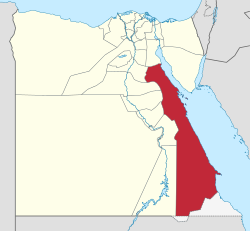
The governorate of al-Bahr al-ahmar ( Egyptian-Arabic Muḥāfẓet El Baḥr El Aḥmar , Arabic محافظة البحر الأحمر Muhāfazat al-Bahr al-ahmar , DMG Muḥāfaẓat al-Baḥr al-aḥmar ' Red Sea '), also the Governorate of the Red Sea , is a governorate in Egypt with 359,888 inhabitants and is located in the eastern part of the Arabian Desert . The governor is Major General and Minister Ahmed Abdullah (as of March 2017).
geography
Al-Bahr al-ahmar borders in the north on the governorate as-Suwais (Suez), in the east on the coast of the Red Sea , in the west on the governorates Aswan , al-Uqsur , Qina , Sauhaj , Asyut , al-Minya and Bani Suwaif . In the south it borders on Sudan and its eponymous state of al-Bahr al-ahmar , on the border lies the controversial area of the Hala'ib triangle between Sudan and Egypt .
administration
The governorate of al-Bahr al-ahmar, including the controversial Hala'ib triangle, is divided into eight districts ( marākiz , singular markaz ), from north to south:
![]() Map with all coordinates: OSM | WikiMap
Map with all coordinates: OSM | WikiMap
| Markaz | Arabic | Area km² |
Population on Nov 11, 2006 |
Coordinates |
|---|---|---|---|---|
| Ras Gharib | قسم رأس غارب | 10,464.46 | 32,369 | ... |
| Hurghada No. 2 | قسم ثان الغردقة | 6,836.55 | 91,285 | ... |
| Hurghada | قسم أول الغردقة | 6,192.85 | 69,616 | 27 ° 13 '25 " N , 33 ° 50' 21" E |
| Safaga | قسم سفاجا | 4,764.59 | 35,379 | ... |
| al-Quseir | قسم القصير | 11,675.36 | 35,920 | ... |
| Marsa Alam | قسم مرسى علم | 24,466.77 | 6,614 | ... |
| Bi'r Schalatain 1) | قسم الشلاتين | 49,677.99 | 15.210 | ... |
| Hala'ib 1) | قسم حلايب | 7,573.28 | 2,268 | ... |
Al-Bahr al-ahmar governorate |
البحر الأحمر | 121,651.85 | 288,661 |
1) The Hala'ib district is not identical to the Hala'ib triangle, but only covers part of it (7573 of 20580 km² or 37 percent of the area) in the east with the largest part of the coast and the inhabited areas. The uninhabited remainder of the disputed area with Sudan is administered by Egypt as part of the Bi'r Schalatain district.
population
In 2006 the population was 359,888, of which more than 320,000 lived in the few towns on the coast. In general, the economic structure of the governorate is concentrated in the cities and tourist centers on the coast. Historically, the population has increased thirty-fold since 1937:
| 1937 | 1947 | 1966 | 1976 | 1986 | 1996 | 2006 | 2010 | 2017 |
|---|---|---|---|---|---|---|---|---|
| 9,914 | 15,929 | 38,000 | 56.191 | 90.491 | 155,695 | 288.233 | 306.722 | 359,888 |
economy

Since the early 1980s, Hurghada has been a popular destination for beach holidaymakers and diving enthusiasts . Starting from Hurghada, tourist centers have also developed in the southern cities of Safaga and al-Qusair and Marsa Alam. These destinations can be reached via the international airports in Hurghada and Marsa Alam . In addition to the countless hotels and tourist businesses on the coast, there are two official nature reserves in al-Bahr al-ahmar: The Wadi-al-Gamal National Park (Valley of the Camels) near the city of Marsa Alam and the Gebel Elba National Park in Hala'ib triangle near the city of Hala'ib . In addition to the tourism industry, fishing is carried out all along the coast. The area over which the governorate extends is rich in minerals such as phosphates . In the region around Ras Gharib, 70% of Egyptian oil production is extracted.
See also
Web links
Individual evidence
- ↑ a b http://www.msrintranet.capmas.gov.eg/pls/indcs/cns_st_001?lang=0&lname= ( page no longer available , search in web archives ) Info: The link was automatically marked as defective. Please check the link according to the instructions and then remove this notice. CAPMAS (Central Agency for Public Mobilization and Statistics), English
- ↑ Citypopulation.de
- ↑ Egypt: Governments & Cities - Population Statistics, Maps, Charts, Weather and Web Information. Retrieved April 15, 2018 .
- ↑ http://www.statoids.com/ueg.html
Alexandria | Aswan | Asyut | al-Bahr al-ahmar | Bani Suwaif | al-Buhaira | Bur Saʿid | ad-Daqahliyya | Dumyat | al-Fayyum | al-Gharbiyya | Giza | al-Ismaʿiliyya | Kafr el-Sheikh | Cairo | Luxor | Matruh | al-Minufiyya | al-Minya | North Sinai | al-Qalyubiyya | Qina | Sauhaj | al-Sharqiyyah | as-Suwais | South Sinai | al-Wadi al-Jadid
former: Helwan | al-Sadis min Uktubar