Grünschlade
|
Grünschlade
municipality Reichshof
Coordinates: 50 ° 58 ′ 13 ″ N , 7 ° 36 ′ 11 ″ E
|
|
|---|---|
| Height : | 380 m above sea level NHN |
| Residents : | 21 (Jan. 1, 2007) |
| Postal code : | 51580 |
| Area code : | 02297 |
|
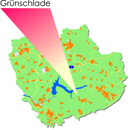
Location of Grünschlade in Reichshof
|
|
Grünschlade is one of 106 districts of the community Reichshof in the Oberbergischer Kreis in the North Rhine-Westphalian administrative district of Cologne in Germany .
Location and description
The closest centers are Waldbröl (15 km south-west), Gummersbach (31 km north-west), Olpe (20 km north-east), Cologne (68 km west) and Siegen (41 km south-east).
history
The small village on the edge of the Odenspieler Feldflur was probably built around 1700.
In 1731 the place consisted of four households with a total of around 20 people, all named Müller.
Population development
| year | population |
| 1817 |
|
| 1861 |
|
| 1982 |
|
| 1991 |
|
| 2007 |
|

