Kamp (Reichshof)
|
Camp
municipality Reichshof
Coordinates: 50 ° 56 ′ 29 " N , 7 ° 46 ′ 56" E
|
|
|---|---|
| Height : | 451 m above sea level NHN |
| Residents : | 11 (Jan. 1, 2007) |
| Postal code : | 51580 |
| Area code : | 02265 |
|
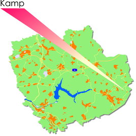
Location of Kamp in Reichshof
|
|
Kamp is a village in the Reichshof municipality in the Oberbergischer Kreis in the North Rhine-Westphalian administrative district of Cologne in Germany .
Location and description
Kamp is west of the Wiehltalsperre , the nearest centers are Gummersbach (24 km northwest), Cologne (61 km west) and Siegen (45 km southeast).
history
First mention
The place was mentioned for the first time in 1575 . "Location on Arnold Mercator's map ."
The spelling of the first mention was Uff dem Camp .
Individual evidence
- ^ Klaus Pampus: First documentary naming of Oberbergischer places (= contributions to Oberbergischen history. Sonderbd. 1). Oberbergische Department 1924 eV of the Bergisches Geschichtsverein, Gummersbach 1998, ISBN 3-88265-206-3 .

