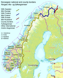
Border between Finland and Norway
The border between Finland and Norway is 736 km long. It is a land and river border (291 km) between two border triangles . The western border triangle is the Treriksröset , a massive border where both countries border on Sweden . The eastern border triangle is Treriksrøysa , a high cairn where both countries border on Russia . For the most part, the land border is marked by unmistakable piles of stones, which were truncated with an attachment and are often marked with a labeled tip.
The border was established in a treaty of 1751 and was then part of the border between the Kingdom of Sweden and the Crown of Denmark , which ruled Norway. In the period from 1738 to 1751 there were field investigations and negotiations about the border line. Unmistakable piles of stones were built in 1766 as border markings as far as Nesseby . After Finland had become a Grand Duchy and an independent Kingdom of Norway was established, another treaty was negotiated with Russia in 1816 , which fixed the easternmost part of the border zone. Between 1920 and 1944 the area around Pechenga belonged to Finland, so that the Finnish-Norwegian border extended along the current Norwegian-Russian border to the ocean.
The Treaty of 1751 granted the Sami people the right to freely cross the border, including their herds, as they had always done as nomads. In 1852 the border between Norway and Finland was closed, causing trouble for the Sami who needed the Finnish forests for winter grazing for reindeer.
The Finnish-Norwegian border is open as both countries are part of the Schengen area . It is legal to cross the border anywhere as long as no customs declaration or passport control is required. Almost half of the border runs along the Anarjohka and Tana rivers . There have been 57 boundary markers north of Treriksröset and west of the Anarjohka River since 1766 , numbered 293 to 342 and 343 to 349 east of the Tana River. Later, further markings were set up east of Nesseby on the border with Finland with numbers up to 353, with a letter after the number.
Border crossings
|
|
↔ |
|
position | ||||||
|---|---|---|---|---|---|---|---|---|---|
|
Treriksrøysa border triangle Finland / Norway / Russia |
69 ° 3 ′ 7 " N , 28 ° 55 ′ 46" E |

|
|||||||
| Näätämö | 971 92 |
|
|
893 |
Envy | 69 ° 40 ′ 35.8 " N , 29 ° 8 ′ 46.3" E |

|
||
| Nuorgam |
|
|
895 | Polmak | 70 ° 5 '18.6 " N , 27 ° 57' 40" E |

|
|||
| Utsjoki | ( ← 977 |
|
|
Sirma | 69 ° 54 '38.7 " N , 27 ° 1' 54.3" E |

|
|||
| Karigasniemi | 92 970 |
|
|
Karasjok | 69 ° 23 '54 " N , 25 ° 50' 36.9" E |

|
|||
| Civil Compolo |
|
|
|
Kautokeino | 68 ° 39 '53.9 " N , 23 ° 19' 14.4" E |

|
|||
| Kilpisjärvi |
21st |
|
|
Helligskogen | 69 ° 6 ′ 42.3 " N , 20 ° 44 ′ 58.5" E |

|
|||
|
Treriksröset border triangle Finland / Norway / Sweden |
69 ° 3 ′ 36 " N , 20 ° 32 ′ 55" E |

|
|||||||
|
|
|||||||||
See also
Notes and individual references
-
↑ Sauli Niinistö : Speech by President of the Republic of Finland Sauli Niinistö at the Norwegian Institute of International Affairs, 11th October 2012. (Speech by Finnish President Sauli Niinistö before the Norwegian Institute for International Affairs) . President of Finland, October 11, 2012, accessed August 9, 2019 . Riksgrenser. Kartverket, September 20, 2018, accessed August 9, 2019 (Norwegian).
- ↑ Svein Askheim: treriksrøysa - Sor-Varanger. Store norske leksikon, accessed August 9, 2019 (Norwegian).
- ↑ Finland was then under Swedish rule
- ↑ Part of the Russian Empire endowed with extensive internal autonomy
-
↑ The Petschenga area borders Finland and Norway to the west and a Barents Sea fjord to the north .

- ↑ Finland was then part of Russia
- ↑ Access is difficult and only possible from Finland (with special permission) or Norway. Entering Russian soil, i.e. walking around the boundary stone, is strictly forbidden. The Russian FSB border guards react very drastically to "border violations". In order to ward off diplomatic entanglements, Norway faces a heavy fine if the border is crossed illegally.
-
↑ a b c d The Finnish 92 is the transit route of the Norwegian

- ↑ Right on the road border, a stone marks the northernmost point of Finland and at the same time the northernmost point of the EU . In fact, this point is in the Tana valley bed about 420 m further north.
- ↑ This is where the European long-distance hiking trail E10 begins through seven countries to Tarifa
- ↑ The conspicuous boundary stone is located on a small headland in Lake Goldajärvi and can be reached by water or a hiking trail through Finland and circled on a footbridge. This stone also marks the westernmost point of mainland Finland.


