
Gumpendorfer Strasse
| Gumpendorfer Strasse | |
|---|---|
|
|
|
 |
|
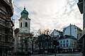
| Gumpendorfer Strasse at the Apollo cinema and the House of the Sea | |
| Basic data | |
| place | Vienna |
| District | Mariahilf |
| Created | z. T. 3rd century |
| Hist. Names | In Saugraben, Kothgasse, Bräuhausgasse, Gumpendorfer Hauptstrasse |
| Name received | 1862 |
| Connecting roads | Eschenbachgasse (northeast), Sechshauser Straße (west) |
| Cross streets | Rahlgasse, Theobaldgasse, Königsklostergasse, Lehargasse, Fillgradergasse, Laimgrubengasse, Bienengasse, Köstlergasse, Stiegengasse, Joanelligasse, Windmühlgasse, Barnabitengasse, Schadekgasse, Magdalenenstrasse, Kopernikusgasse, Otto Blümelgasse, Hofmingmasse, Bauergasse Gasse, Cornelergassezy, Amerlingmühlstrasse, Münhziusgasse Worellgasse, Hirschengasse, Marchettigasse, Webgasse, Grabnergasse, Brückengasse, Stumpergasse, Dominikanergasse, Millergasse, Morizgasse, Sonnenuhrgasse, Hornbostelgasse, Gfrornergasse, Eisvogelgasse, Wallgasse |
| Places | Johanna-Dohnal-Platz, Helene-Bauer-Platz, Fritz-Grünbaum-Platz, Kurt-Pint-Platz, Lutherplatz |
| Subway stations | Gumpendorfer Strasse underground station ( U6 ) |
| use | |
| User groups | Pedestrians , cyclists , motorized private transport , bus route 57A |
| Technical specifications | |
| Street length | approx. 2,440 m |
The Gumpendorferstraße in Vienna runs through the length of the 6th district of Mariahilf .
history

The Gumpendorfer Straße partly follows the course of a Roman road that led to Scarabantia ( Sopron ). (A milestone from the year 252 was found on property no. 39.) At first it was not a continuous street; By and large, it follows the course of the Vienna River .
At the beginning of the 18th century, construction began between Hofmühlgasse and Brückengasse. In the third quarter of the 18th century, the street was almost completely blocked. At important crossroads and at the churches (the Gumpendorfer parish church and the Evangelical Gustav Adolf Church, which was built between 1846 and 1849 ), square-like extensions were created.
From 1754 the existing palace at no. 68–76, including the outbuildings, was transformed into an engineering school for the military and subsequently into the Gumpendorfer barracks . In the course of the barracks transaction , the barracks were abandoned in 1902 and the building was then torn down; on the area was u. a. the Loquaiplatz created.
The name changed over time. Initially called Saugraben , the street was later called Kothgasse , Bräuhausgasse and Gumpendorfer Hauptstraße . After the suburbs were incorporated into Vienna, it was given its current name in 1862. It crossed the suburb of Laimgrube , touched Windmühle and Mariahilf and then led through Gumpendorf , where it finally passed the line wall .
On October 19, 1881, a horse-drawn tram went into operation through Gumpendorfer Strasse; from June 24, 1902, the line ran electrically. From the introduction of the current line scheme in 1907, it carried line signal 57, until 1936 at times an additional 157. On May 13, 1966, the tram was abandoned and replaced by a bus line.
description
Gumpendorfer Straße begins at Getreidemarkt and runs in several arcs in a generally south-westerly direction, essentially parallel to the course of the Wien River. At the beginning is the area of the Technical University of Vienna on the left ; Diagonally opposite to the right, the confluence of Rahlgasse and Theobaldgasse forms a small square (Johanna-Dohnal-Platz) with the animal drinking fountain . A few meters further on, Café Sperl is established on the left . The street climbs between Stiegengasse and Fritz-Grünbaum-Platz and then runs along Esterházypark ; The Apollo cinema is on the left side of the street . From the Brückengasse (Kurt-Pint-Platz) with the Gumpendorfer parish church, the course swings, still in curves, in an approximately westerly direction. At Lutherplatz the street leads past the Evangelical Gustav Adolf Church. Shortly before the end there is a residential building designed by Arik Brauer on the right . The street ends at Gumpendorfer or Mariahilfer Gürtel . After crossing under the viaduct of the former Viennese light rail (now the U6 underground line ), the last few meters are already in the 15th district. The street continues on Sechshauser Strasse in the 15th district.
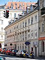
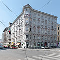
Located in the inner-city area, Gumpendorfer Straße is completely closed. A large part of the building fabric dates from the time of Viennese historicism , with some later buildings and remnants of suburban architecture from the time of Josephinism and Biedermeier .
The only larger green area along the way is the Esterházypark, which is closed off by a high retaining wall across from the street. Otherwise there are only slightly larger green spaces with trees at the beginning of Rahlgasse and Johanna-Dohnal-Platz, the confluence of Lehargasse (Helene-Bauer-Platz), in Windmühlgasse above Gumpendorfer Straße, on the square around Gumpendorfer Church (Kurt-Pint -Platz) and in front of the Gustav-Adolf-Kirche (Lutherplatz) as well as a small tree planting at the confluence of Otto-Bauer-Gasse and Worellstraße.
traffic
The Gumpendorfer Straße opens up the Mariahilf district lengthways. Together with Sechshauser Straße, the continuation beyond the belt in the 15th district, it forms a connection to Linke Wienzeile . It is classified as main street A.
The width of the street only offers space for systems for individual user groups in a few places. There is a multi-purpose lane along the last block of houses in the direction of the city center and a bus lane from Hofmühlgasse to the Esterházypark area , which taxis can also use. Otherwise, cyclists, motorized private transport and urban buses have to share the driving space. There is a speed limit of 30 km / h along the entire length.
Since the tram was discontinued, the 57A bus line has opened up Gumpendorfer Strasse. It is crossed by bus lines 13A and 14A, which , coming in the direction of Mariahilfer Straße from Hofmühlgasse, turn into Gumpendorfer Straße and leave it again via Amerlingstraße. In the opposite direction (13A: to the main train station , 14A: to Reumannplatz ), the bus routes from Schadekgasse cross via Fritz-Grünbaum-Platz into Kaunitzgasse.
There is access to the underground at the Gürtel via the Gumpendorfer Straße underground station (line U6). The U2 line , on the other hand, has no direct access to Gumpendorfer Strasse; the next exit is one block away on Mariahilfer Strasse.
Notable addresses
(Listed objects are highlighted in bold.)
- at No. 6 (Johanna-Dohnal-Platz) animal drinking fountain
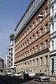
- No. 11–13 Café Sperl
- No. 39 Kolping House
- No. 52 Esterházypark with the House of the Sea (Fritz-Grünbaum-Platz 1)
- No. 54 Esterházy-Hof, Viktor Adler's house
- No. 63 Apollo Cinema
- No. 67 Theater on Gumpendorfer Strasse
- No. 73 Josephine rental house to the eye of God
- No. 95 Biedermeier residential building Marchettihaus
- between No. 105 and 107 (Kurt-Pint-Platz) Gumpendorfer parish church
- No. 108–110 Monastery of the Sisters of Mercy with Chapel of St. Vincent de Paul
- Between No. 129 and 131 (Lutherplatz 1) Gustav-Adolf-Kirche
- No. 132 Factory and residential building, Listo-Film studio
- No. 134–138 Arik Brewery House
- No. 142 Municipal housing in the style of Friedensreich Hundertwasser at the corner of Wallgasse, architect Peter Pelikan
Picture gallery
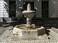
Animal drinking fountain

Café Sperl
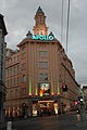
Apollo cinema

Esterházypark and House of the Sea

View from the Haus des Meeres into Gumpendorfer Strasse towards the city

View from the Haus des Meeres into Gumpendorfer Strasse out of town

Stele Reine Form on the stairs to Corneliusgasse

To the eye of God , corner of Hofmühlgasse

Corner of Otto-Bauer-Gasse

Gumpendorfer Strasse / Hornbostelgasse
Marchetti House
Corner of Webgasse
Kurt-Pint-Platz with Gumpendorfer parish church

Convent of the Sisters of Mercy

Gustav Adolf Church
Listo movie

Arik Brewer's House

Corner of Wallgasse

No. 144, the last house on the right side of the street

.jpg)


.jpg)
.jpg)


.JPG)


literature
- Bundesdenkmalamt (Ed.): Dehio Handbuch Die Kunstdenkmäler Österreichs. Vienna II. To IX. and XX. District. Verlag Anton Schroll & Co. ISBN 3-7031-0680-8 . Quoted as Dehio
Web links
Plan view of Gumpendorfer Straße in OpenStreetMap
Individual evidence
- ↑ a b c d Dehio p. 256 ff.
- ^ Gumpendorfer Kaserne in the Vienna History Wiki of the City of Vienna
- ^ A b Gumpendorfer Strasse in the Vienna History Wiki of the City of Vienna
- ^ Kk Polizey district Mariahilf . Plan by Carl Graf Vasquez-Pinas von Löwenthal, ca.1830
- ^ Line 57. In: Tram journal Wiki. Retrieved April 1, 2020 .
- ↑ a b c City Map Vienna. In: Website of the City of Vienna. Retrieved April 1, 2020 .
- ↑ City map Vienna. In: Website of the City of Vienna. Retrieved April 1, 2020 . (Open aerial photo)