
Trages heap

The Halde Trages (sometimes also Hochhalde Trages) is an artificially raised, plateau-like hill, which was created when the Espenhain opencast mine was opened up and was named after the neighboring village of Trages . The Trages heap is wooded and represents one of the highest elevations in the Leipzig administrative district .
location and size
The Trages dump is located about 20 kilometers south-southeast of the center of Leipzig between the villages of Mölbis , Trages and Thierbach and the site of the former Espenhain combine .
The heap has approximately the shape of an equilateral triangle. The three base edges of the heap body have an average edge length of around 2.2 kilometers. This results in an area of around 200 hectares . The edges of the plateau, which also has roughly the triangular shape of the base, are approximately 1.1 kilometers long. The maximum height of the plateau above the dump environment is 66 meters or 231 meters above sea level ; so the heap is dominated by the Collmberg (312 m) and Löbenberg (240 m), for example . The slope angles of the northern and southern embankments are 20 to 25 degrees, that of the eastern flank is 30 to 35 degrees. The volume of the heap body is 85 million cubic meters.
An approximately ten kilometer long circular path with information boards leads across the dump. Access to this path is in Mölbis, alternatively you can take the road coming from Espenhain (closed to motor vehicles).
history

When the exploration of the Espenhain opencast mine began north of Espenhain in 1937, the first excavated material had to be accommodated. They were driven by trains over six to eight kilometers into the area described above and distributed there with two bulk trucks . A height difference of up to 120 meters had to be overcome from the pit to the dump plateau. The tilting area was previously field corridors and the forest area of the Ober- and Untergebirkigt. The tipped material was, depending on its depth, before the excavation, of Pleistocene (boulder clay or marl, gravel, sands, loess) of Oligocene (extremely even-grain sea sands ) or Eocene (sands with carbonaceous additions). The latter material prompted the residents of the surrounding villages to search for coal shares on the dump after the Second World War .
Reforestation work began on the plateau as early as 1950 and lasted until 1964. A total of around one million cuttings from a total of 40 tree and shrub species were planted. From 1968 to 1972 the northern slope and parts of the western embankment were planted. Because of the soil conditions and decades of pollution from the neighboring lignite refining plant, the growth successes were not always satisfactory.
A lack of geotechnical experience with the tilting and neglect of the dump drainage created the risk of landslides, especially of the same-grain material with corresponding water saturation. Between 1952 and 1959, nine landslides with volumes between 40,000 and 900,000 cubic meters, a total of 1.64 million cubic meters or 2% of the dump body, descended on the eastern embankment. On December 12, 1958, a landslide reached as far as Trages, a property that was partially buried. The Mölbis – Trages connecting road had to be relocated in part. To protect against further landslide spreading, a system of diked catch basins was built around the east side of the heap. From 1969 the heap largely came to a standstill.

Already at the end of the 1940s, the dumping of ash from the Espenhain power station began on the southeast flank. With the construction of the large Thierbach power station at the end of the 1960s, the ashes were also flushed in ash basins. Tar and other waste products were also dumped.
With the shutdown of coal processing immediately after the fall of the Wall , the environmental conditions at the Trages dump improved rapidly. In 1999 the Thierbach power plant stopped flushing the ash. The dump became a recreation area. In 1999 the circular route over the dump was opened with various viewpoints, explanatory boards, memorabilia from the earlier mining and a refuge. The Lausitzer und Mitteldeutsche Bergbau-Verwaltungsgesellschaft mbH (LMBV), which manages, renovates and designs the succession landscapes of former lignite opencast mines, built a 33 meter high observation tower in 2002 near the southeast corner of the plateau . The all-round view allows clear views as far as the Ore Mountains , the Thuringian Timber Country and the Petersberg near Halle if the weather conditions are right .
Since 1990 the heap has been owned by a private forest enterprise that has taken over the forestry and hunting care of the heap forest.
Flora and fauna
The trees of the heap presently consists of birches , hybrid poplar , aspen , red and gray alder , black locust , sycamore , stalk and red oaks and Goat grazing together. While the poplars were being planted, birch and aspens gradually settled . The three tree species are considered to be pioneer trees with high adaptability to extreme site conditions and shape the first generation of forests on the dump. The shrub layer is characterized by red dogwood , privet , sea buckthorn and barberry as well as various wild roses , raspberry and blackberry species .

A total of 241 higher plant species , 29 moss or fungus species and 6 lichen species were found on the dump . Floristic peculiarities are the occurrence of real centaury and the orchid species marsh stendellum and flesh-colored orchid on damp locations as well as large two-leaf , broad-leaved and brown-red stendelwort on the plateau. To assign mining landscapes as the stockpile Trages for the floristic species protection important habitat structures. In particular on the nutrient-poor soils, rare and in some cases threatened with extinction plant species that have long since disappeared in the agricultural landscape characterized by excess nutrients.
In the dump area, the larger mammals are represented by deer , wild boar , badger , red fox , brown hare , wild rabbit , hedgehog and stone marten . 73 breeding bird species were observed. About a quarter of these species are on the Red List of the Free State of Saxony. These include, among other quail , Whitethroat , Yellowhammer , tawny pipit , wheatear and Stonechat .
Eight amphibians and two reptile species were found, also for the most part on Saxony's red list. The arid dump also offers favorable habitats for insects and spiders. Over 50 species have been identified so far.
- Views of the heap
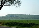
The dump from the north
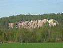
Soil erosion on the east side

Memory of the mining industry

Former Espenhain plant, Lippendorf power plant at the back

Mölbis and Pötzschau,
behind the skyline of Leipzig
Information board in Mölbis


Web links
Individual evidence
- ↑ a b According to information boards on the circular route
- ↑ Halde Trages observation tower at outdooractive.com
Coordinates: 51 ° 11 ′ 9.6 " N , 12 ° 30 ′ 43.9" E