
Garden location
|
|||
|---|---|---|---|
Map:
|
|||
| Basic data | |||
| Area : | 1.443 km² | ||
| Residents : | 3857 As of December 31, 2019 | ||
| Population density : | 2,604 inhabitants / km² | ||
| Postal code : | 49074 | ||
| Primaries : | 0541 | ||
| structure | |||
| District number: |
9 |
||

Gartlage is a district of the Lower Saxon city of Osnabrück . It is located in the immediate vicinity of Osnabrück city center .
At the end of 2019, the Gartlage had 3857 inhabitants, who were spread over 144.33 hectares. Gartlage is the smallest district of Osnabrück, even before the city center (171 hectares).
description

Despite its proximity to the city center, the district is mainly industrial. The largest area takes the factory premises of KM Europa Metal (KME) that also have the company Stadtwerke Osnabrück and Osnatel in Gartlage based. In the south and east of the area of the railway lines will Wanne-Eickel-Hamburg and wages-Rheine limited, at the crossing point is the main station , which is also accessible from the garden.
The rest of the garden area is used for living. There is the vocational Backhausschule (a primary school located in the same building was closed in 2009), a public skate park and a sports facility on the Klushügel with a lawn, tennis courts and other facilities, e.g. for athletics.
history

The name of the Gartlage district can be traced back to the Gartlage estate with its representative manor house from the 16th century, which is now in the Dodesheide district .
During the Nazi era , the NSDAP used the Klushügel for marches. During the Second World War, the Osnabrück copper and wire factory (OKD, today KM Europa Metal ) was the target of the air raids on Osnabrück . Between the first attack on June 23, 1940 and the end of the war in May 1945, 65% of the plant was destroyed.
The southern area of the district was connected to the tram line 3 until around 1958, which ran from Schinkel via Buersche Straße, Neumarkt to Martiniplatz (H.-Lübke-Platz). An additional tram line was already planned from the city center via Alte Poststraße, Bohmter Straße towards Bremer Straße (Schinkel), which did not go into operation, but for which tracks had already been laid below the railway bridge on Bremer Straße.
Population development
The population development of the Gartlage district:
|
|
|
|
Hall garden location
The Gartlage hall is a multi-purpose hall in the Gartlage district. It was built in 1954 and was intended to be used mainly for cattle auctions. Since 2010 it has been owned by the Osnabrück Herdbuch Cooperative from Melle, which owns the Halle u. a. for their own events, such as the monthly breeding cattle auctions and the international Osnabrück Holstein days . In addition to its main function, the hall has always been used for events of all kinds, such as concerts and various trade fairs and markets. To make it more attractive, renovation and modernization work was carried out in the years after the takeover.
The Gartlage hall is divided into two sections: on the one hand the event or auction hall with around 1,200 m² in size and on the other hand the exhibition hall with around 2,880 m² in size. In addition, there is an outdoor area with an area of over 44,000 m². In addition to circus events, flea markets and other open-air events, the Osnabrück annual markets take place there twice a year.
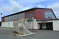
The Gartlage Hall (2015)

Circus at Halle Gartlage (2017)

Autumn fair at Halle Gartlage (2019)

.jpg)

On home game days of VfL Osnabrück at the nearby Bremer Brücke , the outdoor area of the Gartlage hall is often used as a parking lot. The site can be reached via Schlachthofstrasse . In the past, the Gartlage hall also had its own platform on the Wanne-Eickel – Hamburg railway line , which was used for special trips.
Web links
Individual evidence
- ↑ Municipal statistics and monitoring portal Osnabrück (KOSMOS): Population - residents with main residence , osnabrueck.de, accessed on August 3, 2019
- ↑ City of Osnabrück, statistics, size of the city districts and statistical districts 11/2011 (PDF file)
- ↑ Sports facilities in Osnabrück
- ↑ City of Osnabrück, statistics, population by district 2004 - 2014 (PDF file)
- ↑ https://geo.osnabrueck.de/kosmos/bericht_daten_statistik/atlas.html?select=Stadtstrich KOSMOS - Municipal Statistics and Monitoring Portal Osnabrück Figures 2014 - 2019
- ↑ Ludwig Hoffmeyer, Ludwig Bäte, Heinrich Koch: Chronicle of the city of Osnabrück . 4th edition. Meinders & Elstermann, Osnabrück 1982, ISBN 3-88926-004-7 , chap. XVII. 1. "All-round revitalization on a new economic basis (1949–1955)", p. 677 ff .
- ↑ Halle Gartlage on the OsnabrückHalle side ( Memento of the original from August 10, 2010 in the Internet Archive ) Info: The archive link has been inserted automatically and has not yet been checked. Please check the original and archive link according to the instructions and then remove this notice.
Atter | Therefore / Gretesch / Lüstringen | Dodesheide | Eversburg | Fledder | Garden location | Port | Haste | Lightening | Downtown | Limestone hill | Nahne | Pye | Schinkel | Schinkel-Ost | Schölerberg | Sun hill | Sutthausen | Voxtrup | Westerberg | Weststadt | Widukindland | desert
Coordinates: 52 ° 18 ' N , 8 ° 4' E