
Heidt (Ronsdorf)
|
Heidt
City of Wuppertal
Coordinates: 51 ° 12 ′ 56 ″ N , 7 ° 11 ′ 12 ″ E
|
||
|---|---|---|
| Height : | 281 m above sea level NHN | |
| Postal code : | 42369 | |
Location of Heidt in Wuppertal |
||
 View in Heidt
|
||

Heidt is a hamlet in the south of the Bergisch city of Wuppertal, right on the border with Remscheid in North Rhine-Westphalia .
Location and description
The village is located in the southwest of the Ronsdorf district at an altitude of about 280 m above sea level. NHN on a ridge between the Heusiepen and Saalbach streams . The place, together with the neighboring Schmittenberg homestead, has 151 inhabitants (as of 2007).
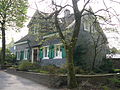
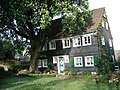
Numerous partly verschieferte Fachwerkhäuser characterizes the historical spatial image, such as the below listed properties House Heidt 14 or immediately adjacent Spritzenhaus Heidt and the former as a natural sight designated powerful horse chestnut , which stand between the two buildings. The small, former fire-fighting equipment house from 1867 is still standing today, but is now used for other purposes. The Heidter fire brigade is now a traditional fire brigade that continues to train its members in terms of fire-fighting technology and is also operational to a limited extent with a handcart. The Easter fire “on the Heidt” has a tradition . Two old two-part "Klön and Kladdertüren", which were common in the agricultural sector in the Bergisches Land, are striking.
There is a metal processing company in David Strasmann & Co. and a garden technology specialist in Otto Reinshagen . There is also an animal health provider in Heidt, Fortan GmbH & Co. KG , as well as the gardening and landscaping company Ralf Feick . Agriculture no longer plays a role today.
A citizen bus connects the village with the center of Ronsdorf. The area around Heidt is popular with hikers and joggers, among others , due to its charming location and proximity to the Ronsdorf dam . There is a small playground in the center of the village.
The Wuppertal circular route , as well as other local hiking trails, cross Heidt.
history
Heidt was first mentioned in 1312. As early as 1685 there was a school in Heidt - so-called "school keeping" initially in private rooms. A plaque on the former village school reminds us that the pedagogue Friedrich Wilhelm Dörpfeld taught here.
In 1715 Erich Philipp Ploennies recorded the court as ufm Heid in his work Topographia Ducatus Montani . On the topographical survey of the Rhineland from 1824 the place is listed as Heydt and on the Prussian first survey of 1843 as Heid .
In 1832 Heidt was the titular place of the Heider Rotte in the rural outskirts of the city of Ronsdorf . The place, categorized as a village according to the statistics and topography of the administrative district of Düsseldorf , had 21 residential buildings, ten agricultural and one public building, the school at that time. At that time there were 258 residents, eight Catholic and 250 Protestant. In the municipality lexicon for the Rhineland province of 1888, 29 houses with 251 inhabitants are given.
Dörpfeldstrasse 28, the former primary school in Heidt
House Heidt 14

Heidt volunteer fire brigade in front of the old syringe house

Klön and Kladdertür at the half-timbered house on Heidt
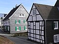
Half-timbered houses on the Heidt


Individual evidence
- ↑ Data sheet of the natural monument
- ^ Klaus-Günther Conrads, Günter Konrad: Ronsdorfer Heimat- und Bürgererverein | from 1246 to 1699. In: ronsdorfer-buergerverein.de. www.ronsdorfer-buergerverein.de, accessed on February 1, 2016 .
- ↑ Johann Georg von Viebahn : Statistics and Topography of the Administrative District of Düsseldorf , 1836
- ↑ Königliches Statistisches Bureau (Prussia) (Ed.): Community encyclopedia for the Rhineland Province, based on the materials of the census of December 1, 1885 and other official sources, (Community encyclopedia for the Kingdom of Prussia, Volume XII), Berlin 1888.