Henglarn
|
Henglarn
City of Lichtenau
Coordinates: 51 ° 35 ′ 58 ″ N , 8 ° 46 ′ 29 ″ E
|
|
|---|---|
| Height : | 179 m above sea level NN |
| Area : | 11.33 km² |
| Residents : | 1048 (December 31, 2014) |
| Population density : | 92 inhabitants / km² |
| Incorporation : | 1st January 1975 |
| Postal code : | 33165 |
| Area code : | 05292 |
|
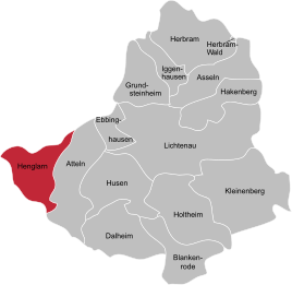
Location of Henglarn in Lichtenau
|
|
Henglarn is the westernmost district of Lichtenau in North Rhine-Westphalia , Germany and belongs to the Paderborn district . Henglarn is also part of the Bürener Land region .
The old postcode of Henglarn is 4791.
geography
Neighboring places
Beginning in the north, Henglarn is bordered clockwise by the Borchen district of Etteln , the Lichtenau district of Atteln and the Bad Wünnenberg districts of Helmern and Haaren . These places all belong to the Paderborn district .
climate
Like Ostwestfalen-Lippe, Henglarn belongs to the oceanic climatic area of northwest Germany , to which it owes its low temperature contrasts and mild winters. However, continental influences are already at work . The temperature in summer is higher and the nights are cooler than in closer proximity to the coast. The location on the Sintfeld results in a colline climate of the hill country level with cooler temperatures and higher precipitation than in other locations in the district.
history
Before January 1, 1975 , the former municipality of Henglarn belonged to the Atteln district in the Büren district . With the entry into force of the Sauerland / Paderborn Act on this day, most of the municipalities of the Atteln Office and thus Henglarn as well will be merged with the municipalities of the Lichtenau Office to form the new city of Lichtenau (Westphalia) and come with this to the Paderborn district. The legal successor to the dissolved office of Atteln and the municipality of Henglarn is the city of Lichtenau.
politics
The head of the Henglarn district is Josef Simon.
Culture and sights
building
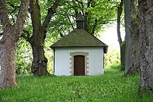
The listed Andreas Church is well worth seeing .
To the north-west of the village is the Vienenburg stables from the late Middle Ages .
Natural monuments
In the Mental near Henglarn there is a special group of temporary springs that form the largest singular alluvial spring cone on the Paderborn plateau.
traffic
Road traffic
Dammstraße runs through Henglarn as the central main street. In the center of the village, Kirchstraße branches off towards Etteln. The Hübelstraße leads to Helmern. Both roads are also known as the K20. The next connection points to the federal trunk road network are the Lichtenau junction on the A44 and the Borchen-Etteln junction on the A33 . The Wünnenberg-Haaren A44 & A33 motorway junction is located in the Harren district of the neighboring town of Bad Wünnenberg.
Local public transport
The city of Lichtenau (Westphalia) is part of the Paderborn / Höxter public transport network . There is only one regular bus line through Henglarn. The regional bus route R82 runs every 30 minutes between the Atteln-Wendeplatz stop and Paderborn main train station. The closest train stations are Paderborn Hauptbahnhof and Altenbeken . Both stations have an InterCity and ICE connection.
See also
Web links
- Information about Henglarn at lichtenau.de
- Homepage of the Heimatverein Henglarn
- Henglarn in the Westphalia Culture Atlas
Individual evidence
- ^ Geographical Commission for Westphalia (ed.): Geographisch-Landeskundlicher Atlas von Westfalen, Topic X Administration and Management, double sheet state and municipal administrative structure , Münster 1990. Cf. Gerhard Henkel : History and Geography of the Büren District. Paderborn 1974, p. 101 f and attached map.
- ^ Gerhard Henkel : History and geography of the Büren district. Paderborn 1974, p. 24 ff.
- ^ Federal Statistical Office (ed.): Historical municipality directory for the Federal Republic of Germany. Name, border and key number changes in municipalities, counties and administrative districts from May 27, 1970 to December 31, 1982 . W. Kohlhammer, Stuttgart / Mainz 1983, ISBN 3-17-003263-1 , p. 320 f .


