Holtheim
|
Holtheim
City of Lichtenau
Coordinates: 51 ° 35 ′ 9 ″ N , 8 ° 54 ′ 35 ″ E
|
|
|---|---|
| Height : | 329 m |
| Area : | 15.85 km² |
| Residents : | 914 (Dec. 31, 2013) |
| Population density : | 58 inhabitants / km² |
| Incorporation : | 1st January 1975 |
| Postal code : | 33165 |
| Area code : | 05295 |
|
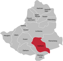
Location of Holtheim in Lichtenau
|
|
Holtheim is a southern district of Lichtenau in North Rhine-Westphalia , Germany and belongs to the Paderborn district . Holtheim is also part of the Bürener Land region .
geography
Neighboring places
Starting in the south in a clockwise direction, the Lichtenau districts of Blankenrode , Husen , Lichtenau and Kleinenberg border Holtheim . The district of Höxter borders the southeast with the Warburg district of Scherfede .
climate
Like Ostwestfalen-Lippe, Holtheim belongs to the oceanic climatic area of northwest Germany , to which it owes its low temperature contrasts and mild winters. However, continental influences are already at work . The temperature in summer is higher and the nights are cooler than in closer proximity to the coast. The location on the edge of the Egge Mountains causes a submontane climate of the low mountain range with cooler temperatures and higher precipitation than in other locations in the district.
history
The name of the village derives from the Low German name "Holt" for "forest" from the suffix -heim indicated here on Frankish origin towards (compared to - live -Ortsnamen in the region, the Saxon origin). The foundation is therefore in the 8th / 9th Century. The village is surrounded by large forests on the Südegge and lies on the border between the Egge Mountains and the Paderborn plateau. For centuries, a large part of the community lived from working in the large surrounding forests. Almost all of the local farms were small and medium-sized. From 1833 to 1917 a glassworks in the hamlet of Marschallshagen, which belongs to Holtheim, produced all kinds of utility and luxury glasses.
In the Holt Heimer district lying deserted villages deserted Marshal Hagen , Rodebredengudt with the Marshal Castle and Sewardissen with the remains of a moth .
Holtheim has belonged to the secular rule of the German diocese Paderborn , originally in the duchy of Saxony , since it was first mentioned in a document in 1015 . From the 14th century, the territory of the prince-bishopric of Paderborn ( Hochstift ) was formed in the Holy Roman Empire , and from the 16th century it became part of the Lower Rhine-Westphalian Empire . In the 17th / 18th In the 17th century, Holtheim was also devastated by foreign troops in several wars, including the War of the Polish Succession in 1734 . In 1802/03 the bishopric was occupied by the Kingdom of Prussia . In Napoleonic times the place was part of the Kingdom of Westphalia . From 1815 Holtheim belonged to the Kingdom of Prussia and from 1871 it was part of the German Empire . 1945–1949 Borgentreich was part of the British zone of occupation , from 1946 governed by the state of North Rhine-Westphalia and from 1949 also by the Federal Republic of Germany .
Incorporation
Before 1 January 1975, the former municipality Holtheim part of the Office Lichtenau (Westfalen) in county Buren . With the entry into force of the Sauerland / Paderborn law on this day, most of the municipalities of the Atteln office will be merged with the municipalities of the Lichtenau office and thus also Holtheim to form the new city of Lichtenau (Westphalia) and will become part of the Paderborn district.
The legal successor to the dissolved office of Lichtenau and the municipality of Holtheim is the city of Lichtenau.
politics
The mayor of Holtheim is Albert Guenther.
natural reserve
Large parts of the Holtheim area have been a nature reserve since 2004 .
Holtheim's sons and daughters
- Wilhelm Knothe (1883–1963), German diplomat during the Nazi era
Trivia
The old postcode of Holtheim is 4791.
See also
literature
- Josef Drewes : Holtheim . In: The Hochstift Paderborn: Portrait of a region . Verlag Ferdinand Schöningh , Paderborn 1997, ISBN 3-506-95293-5 , p. 141-142 .
Web links
- holtheim.de
- Information about Holtheim on lichtenau.de
- Holtheim in the Westphalian Cultural Atlas
Individual evidence
- ↑ Homepage of the municipality of Holtheim , accessed on June 30, 2014.
- ^ Geographical Commission for Westphalia (ed.): Geographisch-Landeskundlicher Atlas von Westfalen, Topic X Administration and Management, double sheet state and municipal administrative structure , Münster 1990. Cf. Gerhard Henkel : History and Geography of the Büren District. Paderborn 1974, p. 101 and map supplement.
- ^ Gerhard Henkel : History and geography of the Büren district. Paderborn 1974, p. 24 ff.
- ^ Gerhard Henkel : History and geography of the Büren district. Paderborn 1974, p. 176.
- ^ Federal Statistical Office (ed.): Historical municipality directory for the Federal Republic of Germany. Name, border and key number changes in municipalities, counties and administrative districts from May 27, 1970 to December 31, 1982 . W. Kohlhammer, Stuttgart / Mainz 1983, ISBN 3-17-003263-1 , p. 320 f .


