Hermann Löns Park
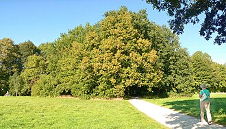
The Hermann-Löns-Park in Hanover is a 86 ha large park in the southeastern metropolitan area in the district Kleefeld , which the forest areas Eilenriede and Tiergarten together. The park is because of the local plants, buildings and land forms an idealized Lower Saxony floodplain . Since its formation as a public park in 1930 -Jahren the park has retained the original shape as much as possible until today. The name is based on the Heide poet Hermann Löns, who is closely associated with Hanover .
location
The districts of Kirchrode and Anderten as well as the forest areas of the Eilenriede and the zoo border the park in the Kleefeld district . The park is delimited by Kirchröder Strasse in the west, by the Hanover – Berlin railway line in the north and by the Hanover freight bypass railway in the southeast . A street leads into the center of the park with a restaurant, at the end of which there is a public parking lot. The park can be reached by public transport using tram line 5.
geology
Marl rocks geologically determine the subsoil. The impermeable chalk clays created a fen on the surface of what is now the park area , which is rich in nutrients compared to the peat bogs north of Hanover ( Altwarmbüchener Moor ).
biology
The nutrient-rich subsoil enables a species-rich flora and fauna. This special value of the park was recognized as early as the 19th century. There are 48 species of birds and 8 of the 18 native bat species in the park's wildlife . The strong gray geese population has been a problem for some years now , contributing to the enrichment of nutrients in the pond, biting the bank vegetation and displacing other waterfowl.
Landscaping
The park area is a delightful landscape in which bodies of water, forest ponds , open meadows with flat edge trees and high forest alternate. The facility was designed in the manner of a floodplain landscape in Lower Saxony and is characterized by numerous valuable biotope types , such as reed beds and sedge beds on the Anna pond as well as tree-covered hedges and wet meadows. When creating the park, the existing Anna pond was enlarged and divided into two halves, giving the impression of a lake landscape. In the area of the Kiebitzberg , a barely noticeable elevation with a birch grove on the north side of the park, there are Ice Age boulders , the largest of which was protected as a natural monument, but has now been designated as a geotope.
Most of the plants in the park are in their natural habitat. Large conifers were not planted as they are not typical of the north-west German landscapes. Instead, there are the tree species or genera pedunculate oak , linden , hornbeam , ash , alder , willow and birch as well as the shrub species hazelnut , elderberry , buckthorn and bird cherry .
Buildings and facilities

The park was built in the 1930s in the style of an open-air museum . In the process, old buildings typical of Lower Saxony were moved to here from other locations. This is how a historic group of buildings was created in a central location in the middle of the park near the Anna pond. It is surrounded on three sides by watercourses. The half-timbered buildings give the impression of an old homestead. The development consists of:
- Hall House (popularly: Lower House ) of 1720, translocated from Wettmar , a long-time dairy and last hostel . Today it houses an upscale restaurant with an old Lower Saxon interior .
- Storage building from 1637 from Eystrup , also called Lönshaus , which is used as an event building for family celebrations.
- Windmill Old mill from 1701, which in recent centuries at various locations in Hanover and Hohnebostel in Langlingen was erected. In 1935 it was decommissioned. In 2008 it was dismantled due to the risk of collapse, as the wood had suffered considerable damage from rotting and knocking beetle infestation . The main cause of damage is the long idle time of the mill. The reconstruction after a restoration took place in July 2012.
Another development is the “Kleefelder Bad” (also called “ Annabad ”) open-air swimming pool , which is barely noticeable from the park due to the cleverly arranged trees and waterways. There are other buildings through the listed permanent colony Annateich as an allotment garden on the north side of the park along the railway line with 220 allotments, garden houses and a club bar. There are also two sports fields and several children's playgrounds in the park.
Post mill , dismantled in 2008 due to dilapidation, rebuilt in 2012
Bridge of the Hanover freight bypass with bridge structure before restoration (2015)
Local of the permanent colony Annateich on the northern edge of the park
Listed garden house (around 1940) of the permanent colony Annateich
history
Site pre-use
Today's park area was a damp fen area in earlier centuries , for which, apart from meadow, hardly any agricultural use came into question. From the 17th century, the site was used to mine clay . The former clay pit later filled with water. From this the originally much smaller Annateich was formed. The railway construction in the 19th century brought about major changes to the landscape of the area officially known as the "area at the Anna pond". When the Hanover – Braunschweig railway was built in 1843 , the route passed here. The same happened with a dam that was raised in 1909 when the Hanover freight bypass was built .
Park creation

The Volkspark idea, which emerged across Europe at the beginning of the 20th century, encouraged the creation of the park. In the course of urban development with cramped living conditions, citizens should be given the opportunity to relax in spacious parks. In 1935, the Hanover city administration announced an ideas competition for the design of the city-owned "area at the Annateich", which the Hanoverian garden architect Wilhelm Hübotter won. According to his plans, the city developed its concept and had it implemented by city authorities, such as the building authority and the gardening department, in part through job creation measures. The work involved large movements of earth in order to create watercourses and to redesign or enlarge the Annateich. They began in 1936 and were completed with the inauguration of the park on August 18, 1939.
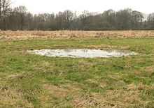
During the air raids on Hanover during World War II , around 350 aircraft bombs fell in the park, apparently intended for the Hanover freight bypass railway that runs through the park area. Even today, numerous bomb craters can be seen as circular depressions in the meadows and lawns , in which surface water collects, especially in spring.
The Hanover Gymnastics Club organizes the Hermann Löns Park Run in the park facilities every year . The fun run is considered the ideal end to the autumn running season and was held for the 40th time in 2016.
literature
- Henrike Schwarz: The Hermann Löns Park. Green area office, Hanover 2001 (free brochure from the green area office Hanover).
- Eva Benz-Rababah : Hermann-Löns-Park . In: Klaus Mlynek, Waldemar R. Röhrbein (eds.) U. a .: City Lexicon Hanover . From the beginning to the present. Schlütersche, Hannover 2009, ISBN 978-3-89993-662-9 , p. 287.
- Verena and Volker Stahnke (text): Hermann-Löns-Park . In: Silke Beck, Susanne Wildermann, Birgit Roos, Burkhard Wetekam (Red.): 12 green treasures. Discovery tours for children in the city and region of Hanover , for children between 5 and 12 years, publisher: Wissenschaftsladen Hanover eV in cooperation with the state capital Hanover and the Hanover region, Hanover: Transfer-Medien, 2013, ISBN 978-398-14315-5 -1 ; Table of contents and publisher's announcement ( Memento of May 5, 2015 in the Internet Archive ), pp. 36–43.
Web links
- Park description at hannover.de
- Park description, pictures and map
- On the history of the historical buildings in Hermann-Löns-Park
- Interactive 360 ° panorama photo of Hermann Löns Park
Individual evidence
- ↑ Loensparklauf.de , accessed on November 12, 2017.
Coordinates: 52 ° 22 ′ 11 ″ N , 9 ° 49 ′ 3 ″ E


