
Hohe Warte (ridge)
| High wait | ||
|---|---|---|
 |
||
| height | 463 m above sea level NHN | |
| location | Country: Bavaria / Bayreuth district
Municipalities: Bindlach / Heinersreuth / Bayreuth |
|
| Mountains | Fichtel Mountains | |
| Coordinates | 49 ° 58 ′ 6 " N , 11 ° 34 ′ 30" E | |
|
||
| Type | Mountain range | |
| rock | Red sandstone | |
| particularities | - Many rock faults ( Benk formation ) - Siegesturm ( AT ) |
|

_Bayreuth.JPG)

The ridge Hohewarte (318- 463 m above sea level. NHN ), not to be confused with the same mountain in the nearby Berneck is a three striking elevations, mainly wooded formation on the southwestern edge of Fichtelgebirges north of and in Bayreuth . The springs, streams and lakes of the Hohe Warte are important for the water supply of the surrounding places.
Communities
About 60% of the ridge (in the north and east) are in the municipal area of Bindlach , the rest is spread over the urban area of Bayreuth (in the south) and the municipality of Heinersreuth (in the west).
The following villages or parts of the municipality are located directly on the mountain range:
|
|
|
summit

|
Waters
Rivers / streams:
- The Hirschbach rises on the Hirschberg and flows into the Trebgast
- The Eisbach rises in the Eisbachsee and flows into the Trebgast
- The Cottenbach rises in the Hirschbergsee and flows into the Red Main
- The Altbach rises at the foot of the Schupfenschlager Höhe and flows into the Trebgast
Lakes:
- Eisbachsee
- Hirschbergsee
- Schupfenschlager Weiher
rock
- Neuhauser Felsmassiv (near Neuhaus)
- Eisgrube (near the pen)
- Eisbachklamm (near Buchhof)
- Sandstone cliffs Hohe Wart (near Hermannshof)
- Cottenbachklamm (near Euben)
- Ludwigsfelsen named after King Ludwig I of Bavaria (near Hochtheta / Kühnleite)
Leisure and Tourism
Almost the entire Hohe Warte is designated as a landscape protection area. The area around the Siegesturm on the Hohe Wart is mainly developed for tourism, but the eastern part is less open . A playground was created in a former sand quarry near the summit , supplemented by a football field with basketball hoops . A popular excursion destination with a beer garden and children's playground is the Gasthaus Auf der Theta , a former agricultural property in the Hochtheta district of Bindlach.
The Nortwaldweg hiking trail begins on the southern slope of the Hohe Warte.
Economical meaning
The area is important for the timber industry, it is used and maintained by the Bavarian State Forests .
The source area around the Hohe Wart is used almost exclusively to supply the city of Bayreuth with water. In 1980 an elevated drinking water tank with a capacity of 10,000 cubic meters was put into operation there, which has now been given a new company building. This container also stores the water that is obtained from around 90 spring taps on the southern slope of the Ochsenkopf in the Fichtelgebirge . From there, 23% of Bayreuth's drinking water comes into the city via a 30-kilometer pipeline with around 3.4 million liters per day.
In the area of the city of Bayreuth, two groups of a forest kindergarten with 40 children use the area. The establishment of a funeral forest planned by an association is controversial , the facility of which threatens to affect the forest children.
To the east of the Hohe Wart lies the Hohe Warte Clinic, named after the ridge .
gallery
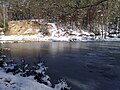
Eisbachsee

Eisbachklamm
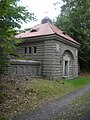
Old operational building of the elevated tank

Gasthaus Auf der Theta , gable wall with window aprons


Web links
Individual evidence
- ↑ Map services of the Federal Agency for Nature Conservation ( information )
- ^ Ordinance on the protection of landscape areas in the area of the city of Bayreuth and the districts of Bayreuth and Kulmbach ("Hohe Warte / Maintalhang") . In: Government of Upper Franconia (ed.): Official Gazette of the Government v. Ofr. Episode 7/76. Bayreuth April 5, 1976 ( bayreuth.de ). bayreuth.de ( Memento of the original dated December 6, 2010 in the Internet Archive ) Info: The archive link was inserted automatically and has not yet been checked. Please check the original and archive link according to the instructions and then remove this notice.
- ↑ Hohe Warte playground: The forest adventure . nordbayerischer-kurier.de, October 4, 2013; accessed on September 7, 2015
- ↑ Fichtelgebirgsverein Bayreuth local group: hiking trails partner associations , accessed on August 28, 2015.
- ↑ 75 years of Stadtwerke Bayreuth In: Our Stadtwerke , customer magazine of BEW and BVB, issue 2/2014, p. 11
- ^ Elevated reservoir Hohe Warte at: Hof Wasserwirtschaftsamt, accessed on September 6, 2015
- ↑ Be careful when building a cable car in: Nordbayerischer Kurier, December 19, 2018, p. 17.
- ↑ No rest around the quiet forest . In: Nordbayerischer Kurier , 7 August 2015, p. 11.
- ↑ About us - Klinikum Bayreuth GmbH. Retrieved June 12, 2008 .