Bay Harbor Islands
| Bay Harbor Islands | |
|---|---|
|
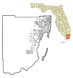
County and state location
|
|
| Basic data | |
| Foundation : | 1947 |
| State : | United States |
| State : | Florida |
| County : | Miami-Dade County |
| Coordinates : | 25 ° 53 ′ N , 80 ° 8 ′ W |
| Time zone : | Eastern ( UTC − 5 / −4 ) |
| Residents : | 5,628 (as of 2010) |
| Population density : | 5,628 inhabitants per km 2 |
| Area : | 1.6 km 2 (approx. 1 mi 2 ) of which 1.0 km 2 (approx. 0 mi 2 ) is land |
| Postal code : | 33154 |
| Area code : | +1 305 |
| FIPS : | 12-03975 |
| GNIS ID : | 0278201 |
| Website : | www.bayharborislands.org |
| Mayor : | Stephanie brother |
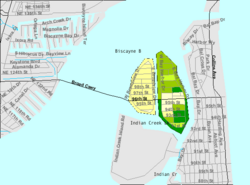
 US Census Bureau map showing city limits |
|
Bay Harbor Islands is a city in Miami-Dade County in the US state of Florida with 5628 inhabitants (as of 2010).
geography
The urban area consists of two islands in Biscayne Bay . On the western one there are only single-family houses, while on the eastern island there is a business district and apartment buildings. Surrounding communities are North Miami , Bal Harbor , Surfside, and Indian Creek .
history
The city was founded by Shepard Broad, who immigrated to the United States from Pinsk in Russia in 1920 . In 1945 Broad acquired two undeveloped islands between the mainland in northern Miami and the elongated island on which Miami Beach is located. In 1947 Bay Harbor Islands was registered as a town. Today it is led by an elected city council with seven members.
The first building permit was applied for on June 15, 1947 and within four years 46 houses were built, in which around 550 people lived. The concept of only allowing single-family homes on the 103 acre island to the west originated from Broad. The eastern island has an area of 150 acres and there is a small business district in addition to apartment blocks.
In 1951 the road connection (the Broad Causeway ) to the mainland was opened.
Demographic data
According to the 2010 census, the then 5628 inhabitants were distributed over 3199 households. The population density was 5628.0 inh / km². 91.5% of the population identified themselves as whites , 2.5% as African American , 0.2% as Indians and 1.2% as Asian Americans . 2.2% said they belonged to another ethnic group and 2.3% to several ethnic groups. 46.3% of the population were Hispanics or Latinos .
In 2010 children under 18 years of age and 29.1% of all households lived in 27.4% of all households with persons at least 65 years of age. 55.3% of households were family households (consisting of married couples with or without offspring or one parent with offspring). The average household size was 2.17 people and the average family size was 2.88 people.
23.1% of the population were younger than 20 years, 25.2% were 20 to 39 years old, 29.7% were 40 to 59 years old, and 21.9% were at least 60 years old. The mean age was 41 years. 46.5% of the population were male and 53.5% were female.
The median annual income was $ 55,731, with 12.4% of the population living below the poverty line.
In 2000, English was the mother tongue of 52.04% of the population, 43.90% spoke Spanish and 4.06% had another mother tongue.
traffic
Florida State Road 922 runs through the city . The nearest airports are Opa-locka Executive Airport (national, 15 km away) and Miami International Airport (25 km).
crime
The crime rate in 2010 was 78 points (US average: 266 points) in the low range. There was one rape, 28 break-ins, 30 thefts and six car thefts.
Web links
- Website of the city (Engl.)
Individual evidence
- ↑ http://www.bayharborislands-fl.gov/mayor-and-council
- ^ History . Town of Bay Harbor Islands. Retrieved April 4, 2020.
- ^ Profile of General Population and Housing Characteristics: 2010 . United States Census Bureau . Retrieved March 17, 2013.
- ↑ Language distribution 2000 . Modern Language Association . Retrieved March 17, 2013.
- ↑ http://www.city-data.com/crime/crime-Bay-Harbor-Islands-Florida.html

