Hohendorf (Steinreich)
|
Hohendorf
Community Steinreich
Coordinates: 51 ° 56 ′ 48 ″ N , 13 ° 33 ′ 36 ″ E
|
|
|---|---|
| Height : | 101 m above sea level NHN |
| Area : | 47 ha |
| Residents : | 84 (Dec 31, 2006) |
| Population density : | 179 inhabitants / km² |
| Incorporation : | April 14, 1966 |
| Incorporated into: | Sellendorf |
| Postal code : | 15938 |
| Area code : | 035452 |
|
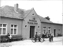
Hohendorf Culture House, 1955
|
|
Hohendorf is a part of the municipality of Sellendorf , a district of the official municipality of Steinreich in the Dahme-Spreewald district in Brandenburg . Until April 14, 1966, Hohendorf was an independent municipality.
location
Hohendorf is located in Niederlausitz and on the south-eastern edge of the Fläming , about 23 kilometers as the crow flies east of the city of Lübben . Surrounding villages are the villages of Altgolßen in the north and Landwehr in the east, which belong to the town of Golßen , the Drahnsdorf districts of Falkenhain in the southeast and Schäcksdorf in the south, Schöneiche in the west and Sellendorf in the northwest.
The Schönerlinde residential area belongs to Hohendorf .
history
The street perimeter village of Hohendorf was first mentioned in a document in 1455. The spelling at that time was Hogendorf . The place name refers to the high altitude of Hohendorf.
According to the topographical-statistical overview of the administrative district of Frankfurt ad O. from 1844, there were 19 residential buildings in Hohendorf that year, the place then had 147 inhabitants. There was a windmill and a brick factory in the village. The Hohendorf manor was then owned by a Mr. Funk, the place was parish after Golßen. In 1867 there were 21 residential buildings with 152 inhabitants in Hohendorf, the windmill was no longer mentioned. Nine people lived in the Schönerlinde Vorwerk belonging to Hohendorf .
At the Congress of Vienna in 1815, after the defeat of the Kingdom of Saxony, it was decided to assign territory to the Kingdom of Prussia , which also affected Hohendorf. After that, the community was in the district of Luckau in the administrative district of Frankfurt in the province of Brandenburg . After the end of the Second World War, the community of Hohendorf became part of the Soviet occupation zone and later the GDR . During the district reform on July 25, 1952, the village came to the Luckau district in the Cottbus district , where Hohendorf was incorporated into Sellendorf on April 14, 1966 . After reunification , the Luckau district was renamed the Luckau district and finally dissolved. In the course of the Brandenburg district reform in 1993 , the community of Sellendorf and its districts came to the district of Dahme-Spreewald . Sellendorf again merged with the municipality of Glienig on December 31, 2002 to form the new municipality of Steinreich , which belongs to the Unterspreewald office .
Population development
| Population development in Hohendorf from 1875 to 1964 | |||||||||||||||||||
|---|---|---|---|---|---|---|---|---|---|---|---|---|---|---|---|---|---|---|---|
| year | Residents | year | Residents | year | Residents | ||||||||||||||
| 1875 | 142 | 1925 | 108 | 1946 | 145 | ||||||||||||||
| 1890 | 113 | 1933 | 89 | 1950 | 135 | ||||||||||||||
| 1910 | 117 | 1939 | 82 | 1964 | 104 | ||||||||||||||
proof
- ↑ Community and district directory. In: geobasis-bb.de. Land surveying and geographic base information Brandenburg, accessed on August 2, 2018 .
- ↑ Reinhard E. Fischer : The place names of the states of Brandenburg and Berlin. Age - origin - meaning . be.bra Wissenschaft, Berlin 2005, p. 78 .
- ↑ Topographical-statistical overview of the administrative district of Frankfurt ad O. 1844, p. 155 ( bsb-muenchen.de ).
- ↑ Statistical Bureau of the Royal Government of Frankfurt a. O .: Topographical-statistical manual of the government district of Frankfurt a. O. Verlag von Gustav Harnecker u. Co., Frankfurt ad O. 1867, online at Google Books , p. 178
- ^ Hohendorf in the historical index of places. Retrieved August 2, 2018 .
- ↑ Historical municipality register of the state of Brandenburg 1875 to 2005. (PDF; 331 KB) District Dahme-Spreewald. State Office for Data Processing and Statistics State of Brandenburg, December 2006, accessed on August 2, 2018 .
