Hradiště (České Lhotice)
| Hradiště | ||||
|---|---|---|---|---|
|
||||
| Basic data | ||||
| State : |
|
|||
| Region : | Pardubický kraj | |||
| District : | Chrudim | |||
| Municipality : | České Lhotice | |||
| Geographic location : | 49 ° 51 ' N , 15 ° 47' E | |||
| Height: | 470 m nm | |||
| Residents : | 38 (March 1, 2001) | |||
| Postal code : | 538 25 | |||
| License plate : | E. | |||
| traffic | ||||
| Street: | Nasavrky - Křižanovice | |||
Hradiště (German Hradischt , 1939–45 Radisch ) is a district of the municipality České Lhotice in the Czech Republic . It is located two kilometers northwest of Nasavrky and belongs to the Okres Chrudim .
geography
Hradiště is located in the Iron Mountains ( Železné hory ) in the area of the protected landscape area CHKO Železné hory in the headwaters of the Hradišťský brook. To the north stretches the Krkanka - a deeply cut wooded valley of the Chrudimka -, behind it the Na Vyhlídce (452 m nm) rises. The remains of the Hradiště oppidum are located on the spur northwest of the village, surrounded on three sides by the Chrudimka . To the west is the Křižanovice I reservoir, to the east the Debrný potok valley.
Neighboring towns are Slavice, Mešiny and Výškov in the north, Práčov , Radochlín, V Limbu, Liština and Libáň in the north-east, Drahotice, Obořice and Ochoz in the east, Nasavrky in the south-east, Hodonín and České Lhotice in the south, Vedralka in the south-west, Kopáčov, Mezvětít 2 díl and Mezisvětí 1. díl in the west and Křižanovice in the north-west.
history
In the 2nd century BC A significant Celtic oppidum existed on the spur surrounded on three sides by the Chrudimka.
Hradiště was probably founded at the end of the 1st millennium. In the 12th century the area came to the Wilmzell Benedictine monastery . The first written mention of Hradisstie took place in 1329, when the Wilmzeller abbot Jaroslav and the prior Všeslav left the Bojanover district with the exception of Křižanovice to Heinrich von Lichtenburg . The Bojanover Sprengel came under the administration of the Lichtenburg and in the 15th century became part of the Oheb Castle . In 1564 the goods of the desert Oheb Castle were attached to the Seč domain . In 1628 Johann Záruba von Hustířan sold the Seč reign with Bojanov to the imperial lieutenant colonel Franz de Cuvier, who united them with his Nassaberg reign . Most of the residents of Hradiště and the surrounding towns stuck to their Helvetic creed despite the Counter-Reformation and persecution . The services were held in secret places. According to the Josephine tolerance patent , a Helvetic community was formed in Hradiště in 1783. The first wooden prayer house was consecrated in 1787. The new evangelical rectory was completed in 1835.
In 1835, the in consisted Chrudim District village located Hradischt or Hradisstě of 18 houses in which 133 people, including 17 Protestant families lived. There was a Swiss prayer house and pastorate in the village . The Catholic parish was Nassaberg. In the years 1842–1847 a brick tolerance church was built in place of the old prayer house . Until the middle of the 19th century, Hradischt remained subject to Nassaberg rule.
After the abolition of patrimonial Hradiště formed from 1849 a district of the municipality České Lhotice in the judicial district Nassaberg . At the end of 1860 the Evangelical cemetery was consecrated next to the church. The Protestant school was built in the years 1861–1862. From 1868 the village belonged to the political district of Chrudim . In 1869 Hradiště had 143 inhabitants. In 1900 there were 142 people in the village, compared to 138 in 1910. After the establishment of Czechoslovakia , numerous tramp settlements emerged in the Chrudimka Valley , known as Stříbrná řeka . Between 1948 and 1954 the Chrudimka was dammed below the oppidum with the dam Křižanovice I, which supplies the towns of Pardubice and Chrudim with drinking water; the settlement U řeky was dissolved and flooded. In 2001 there were 38 people living in 19 houses in Hradiště.
Community structure
The district of Hradiště is part of the cadastral district of České Lhotice.
Sights and culture
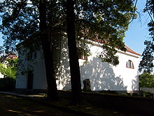
- Evangelical Church of Tolerance, built 1842–1847
- Jan Hus memorial stone
- Reservoir Křižanovice I, the dam built between 1948 and 1954 serves to supply drinking water.
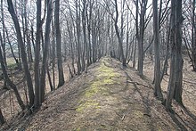
- Oppidum Hradiště
- Celtic educational trail, the circular route leads from Nasavrky via České Lhotice and Hradiště to the oppidum and the Hradišťský vodopád.
- The Boika lookout tower on the hill south of Hradiště, built in 2006. The wooden structure named after the Boiern has a height of 14.5 m; the viewing platform is 11 m high.
- Krkanka nature reserve in the Chrudimka valley north of the village. There is also the Hradišťský vodopád ( Hradiště waterfall ).
literature
- Historický lexikon obcí České republiky 1869–2005 , part 1, p. 508
Web links
Individual evidence
- ^ Johann Gottfried Sommer : The Kingdom of Bohemia; Represented statistically and topographically. Volume 5: Chrudimer Kreis. Prague 1837, p. 265
- ↑ http://www.uir.cz/casti-obce/022624/Hradiste
- ↑ http://www.ceskelhotice.cz/turistika/turistika_rozhledna.html


