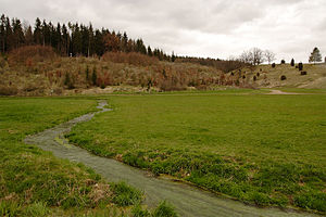
Hungerwell, Sacken and Lone Valley
|
FFH area
"Hungerbrunnen-, Sacken- and Lone Valley" |
||
|
Hungerwell Valley |
||
| location | Four towns and communities in the district of Heidenheim , district of Göppingen and Alb-Donau district in Baden-Württemberg , Germany | |
| Identifier | DE-7426-341 | |
| WDPA ID | 555521925 | |
| Natura 2000 ID | DE7426341 | |
| FFH area | 91.8 ha | |
| Geographical location | 48 ° 36 ' N , 10 ° 1' E | |
|
|
||
| Setup date | January 1, 2005 | |
| administration | Regional Council Stuttgart | |
The FFH area Hungerbrunnen-, Sacken- and Lonetal is a protected area (protected area identifier DE-7426-341) in the German federal state registered in 2005 by the Stuttgart regional council according to Directive 92/43 / EEC (Fauna-Flora-Habitat Directive) Baden-Württemberg. With the ordinance of the regional council of Stuttgart on the definition of areas of community importance of October 30, 2018, the area was determined.
location
The 917.9 hectare FFH area belongs to the natural areas 096- Albuch and Härtsfeld and 097- Lonetal-area alb within the natural spatial main unit 09 - Swabian Alb . It is located in the Lone Valley with side valleys between Gussenstadt and Heuchlingen on the markings of four cities and municipalities. The core is between Gerstetten and Altheim.
- District of Göppingen:
- Geislingen an der Steige : 9.179 ha = 1%
- District Heidenheim:
- Gerstetten : 403.8795 ha = 44%
- Alb-Danube district:
- Altheim (Alb) : 486.4912 ha = 53%
- Rammingen : 18.3581 ha = 2%
Description and purpose of protection
It is about the occasionally dry, meandering streams of the Lone with their tributaries and their valleys on the arid Eastern Jura with juniper heaths, remains of steppe heather and species-rich beech forests on the heights. There are two caves in the area.
Habitat classes
(general characteristics of the area) (percentage of total area)
Information according to the standard data sheet from the Official Journal of the European Union
| N10 - Moist and mesophilic grassland | 33% | |||
| N14 - Meliorated grassland | 2% | |||
| N15 - Other farmland | 3% | |||
| N16 - deciduous forest | 29% | |||
| N17 - coniferous forest | 6% | |||
| N19 - mixed forest | 26% | |||
| N23 - Other (including cities, villages, roads) | 1 % | |||
Habitat types
According to Appendix 1 of the ordinance of the Stuttgart Regional Council on the definition of areas of Community importance (FFH ordinance) of October 30, 2018, the following habitat types according to Annex I of the Habitats Directive occur in the area:
| EU code |
Habitat type (official name) | Short name | Hectares |
|---|---|---|---|
| 5130 | Formations of Juniperus communis on limestone heaths and lawns | Juniper Heath | 93.52 |
| 6110 | Gap basophilic or lime pioneer lawn (Alysso-Sedion albi) | Lime pioneer lawn | 0.97 |
| 6210 | Near-natural dry lime lawns and their stages of shrubbery (Festuco-Brometalia) | Lime grassland | 58.46 |
| 6510 | Lean lowland hay meadows (Alopecurus pratensis, Sanguisorbaofficinalis) | Lean, lowland hay meadows | 4.15 |
| 8160 | Calcareous debris heaps of the colline bismontane level of Central Europe | Lime debris heaps | 0.16 |
| 8210 | Limestone cliffs with crevice vegetation | Limestone cliffs with crevice vegetation | 1.21 |
| 8310 | Caves that are not open to tourists | caves | 0.01 |
| 9130 | Woodruff beech forest (Asperulo-Fagetum) | Woodruff beech forest | 358.60 |
| 9150 | Central European orchid-lime-beech forest (Cephalanthero-Fagion) | Orchid beech forests | 2.81 |
| 9180 | Tilio-Acerion canyon and slope mixed forests | Mixed ravine and hillside forests | 5.77 |
Contiguous protected areas
The FFH area consists of eight sub-areas. It is completely within the conservation area Hungerbrunnental. The nature reserve no. 4260 - Hungerbrunnental is located within the FFH area . The Hungerbrunnenquelle on Markung Gerstetten is also protected as a natural monument.
See also
Web links
- Data evaluation sheet and map in the profile of the FFH area in the protected area directory of the LUBW
- Profile of the Natura 2000 area 7426-341 Hungerbrunnen, Sacken and Lone Valley (FFH area) at the Federal Agency for Nature Conservation

