Münsinger Alb
|
FFH area "Münsinger Alb"
|
||
|
Münsinger Hardt |
||
| location | District of Reutlingen , Baden-Württemberg , Germany | |
| Identifier | DE-7523-311 | |
| WDPA ID | 555623523 | |
| Natura 2000 ID | DE7523311 | |
| FFH area | 65.45 km² | |
| Geographical location | 48 ° 27 ' N , 9 ° 34' E | |
|
|
||
| Setup date | January 1, 2015 | |
| administration | Regional Council Tübingen | |
The FFH area Münsinger Alb is located in the east of Baden-Württemberg and is part of the European Natura 2000 network of protected areas . It was designated in 2015 through the amalgamation of two already existing FFH areas by the Tübingen Regional Council.
location
The approximately 6545 hectare (ha) large protected area Münsinger Alb is located in the natural areas Mittlere Kuppenalb and Mittlereflächealb . The ten sub-areas are located in the communities of Heroldstatt , Laichingen and Schelklingen in the Alb-Donau district , in Münsingen , Bad Urach , Römerstein and in the community-free manor district of Münsingen in the Reutlingen district .
description
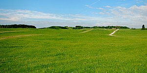
The landscape character of the protected area is mainly shaped by the Münsinger Hardt . The area was previously used as a sheep pasture and between 1895 and 2005 as a military training area. This use has resulted in large-scale grassland complexes. Other landscape-defining elements are the deeply cut valley depressions with sloping and ravine forests and the juniper heaths around Münsingen.
history
The protected area was created in 2015 by merging the original FFH areas 7522-342 "Wacholderheiden bei Münsingen" and 7523-341 "Military training area Münsingen". These have existed since 2005.
Protection purpose
Habitat types
The following habitat types according to Annex I of the Habitats Directive occur in the area:
| EU code |
* | Habitat type (official name) | Short name |
|---|---|---|---|
| 3150 | Natural eutrophic lakes with magnopotamion or hydrocharition vegetation | Natural nutrient-rich lakes | |
| 5130 | Formations of Juniperus communis on limestone heaths and lawns | Juniper Heath | |
| 6110 | * | Gap basophilic or lime pioneer lawn (Alysso-Sedion albi) | Lime pioneer lawn |
| 6210 | Near-natural dry lime lawns and their stages of shrubbery (Festuco-Brometalia) | Lime grassland | |
| 6230 | * | Species-rich montane grass grass (and submontane on mainland Europe) on silicate soils | Species-rich bristle grass lawn |
| 6430 | Moist tall herbaceous vegetation of the planar and montane to alpine level | Moist tall herbaceous vegetation | |
| 6510 | Lean lowland hay meadows (Alopecurus pratensis, Sanguisorba officinalis) | Lean, lowland hay meadows | |
| 6520 | Mountain hay meadows | Mountain hay meadows | |
| 8160 | Calcareous debris heaps of the colline to montane level of Central Europe | Lime debris heaps | |
| 8210 | Limestone cliffs with crevice vegetation | Limestone cliffs with crevice vegetation | |
| 8310 | Caves that are not open to tourists | Caves and balms | |
| 9130 | Woodruff beech forest (Asperulo-Fagetum) | Woodruff beech forest | |
| 9150 | Central European orchid-lime-beech forest (Cephalanthero-Fagion) | Orchid beech forests | |
| 9180 | * | Mixed ravine and hillside forests (Tilio-Acerion) | Mixed ravine and hillside forests |
Species inventory
The following types of community interest exist in the area:
| image | EU code |
* | Art | scientific name | Species group |
|---|---|---|---|---|---|

|
1087 | Alpine buck | Rosalia alpina | Beetle | |

|
1323 | Bechstein's bat | Myotis bechsteinii | Mammals | |

|
1324 | Great mouse ear | Myotis myotis | Mammals | |

|
1381 | Green broom moss | Dicranum viride | Mosses | |
| 1882 | Big brim | Bromus grossus | plants |
Contiguous protected areas
The following nature reserves are part of the FFH area:
The FFH area is largely part of the Middle Swabian Alb bird sanctuary .
See also
Individual evidence
- ↑ a b c Tübingen regional council (ed.): Management plan for the FFH area 7523-311 “Münsinger Alb” . edited by ARGE "IVL / INA Südwest / Trautner". September 30, 2015 (164 pages, baden-wuerttemberg.de [PDF]).
Web links
- Standard data sheet for the FFH area "Münsinger Alb"
- Profile of the FFH area Münsinger Alb in the protected area directory of the LUBW
- Regional Council Tübingen (Ed.): Management plan for the FFH area 7523-311 “Münsinger Alb” . edited by ARGE "IVL / INA Südwest / Trautner". September 30, 2015 (164 pages, baden-wuerttemberg.de [PDF]).

