
Inja (Altai Republic)
| Village
Inja
Иня
|
||||||||||||||||||||||||||
|
||||||||||||||||||||||||||
|
||||||||||||||||||||||||||


Inja ( Russian Иня ) is a village (selo) with 798 inhabitants (as of October 14, 2010) in the highlands of the Russian Altai on the South Siberian highway M52 .
The place is in the high mountain valley of the Katun , the largest Ob source river, in the north of the Belucha massif ( 4506 m ). It extends for about two kilometers on a low river terrace ; another terrace is located above the village about 200 meters above the valley floor. A few kilometers upstream, the river coming from the Belucha massif turns from its north-east to a north-west direction, and the Chuja tributary flows from the right .
The M52 from the border pass to Mongolia , the 2482 m high Durbet Daba, comes from its valley . Not far from Inja, the road leaves the broad shoulder of the valley and crosses the now narrow main valley to ascend into a western side valley opposite. There it continues in the direction of the Siberian metropolis of Novosibirsk, about 600 kilometers away .
The place is the seat of the rural community Ininskoje selskoje posselenije with a total of 1719 inhabitants (as of October 14, 2010), to which besides Inja the five smaller villages Akbom, Iodro, Inegen, Malaja Inja and Maly Jaloman belong. The right tributary of the same name of the Katun, Inja , flows into Inja.
The prehistoric petroglyphs found in the vicinity of the village, as well as rock altars and the “guardians of time”, old stone female figures, are culturally significant .
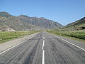
The Russian-Mongolian trunk road M52 (Chuysky trakt) near Inja. Here it still runs on the broad shoulder of the valley

The Chuja valley above Inja

Lenin monument


Individual evidence
- ↑ a b c Itogi Vserossijskoj perepisi naselenija 2010 goda. Tom 1. Čislennostʹ i razmeščenie naselenija (Results of the All-Russian Census 2010. Volume 1. Number and distribution of the population). Tables 5 , pp. 12-209; 11 , pp. 312–979 (download from the website of the Federal Service for State Statistics of the Russian Federation)
Web links
- Russian Altai, map of the TU Dresden
- Inja River Bridge, M52 and associated GoogleEarth aerial photo atlas
- Google Maps, Belucha-Inya-Altai