Elekmonar
| Village
Elekmonar
Элекмонар
|
||||||||||||||||||||||||||
|
||||||||||||||||||||||||||
|
||||||||||||||||||||||||||
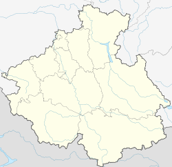
Elekmonar ( Russian Элекмона́р ; South Maltese Эликманар , Elikmanar ) is a village (selo) in the Altai Republic ( Russia ) with 1755 inhabitants (as of October 14, 2010).
geography
The place is about 50 km as the crow flies south of the republic capital Gorno-Altaisk in the Russian Altai , west of the Iolgo ridge, which reaches an altitude of 2385 m with the summit of the Akkaja about 35 km from the place . Elekmonar extends for about 5 km in a narrow strip along the right bank of the Katun and about 3 km up the valley from its right tributary Elekmonar ( Elikmanar ).
The village belongs to the Chemalsky Rajon ; its center is about 5 km north of the Rajon administrative seat of Chemal . It is the seat of the rural community Elekmonarskoje selskoje posselenije, which includes the village of Elekmonar and the small village of Karakol with only 8 inhabitants.
history
In 1933 the village became the administrative seat of the Chemalski aimak, founded in 1922, of the then Oirot Autonomous Oblast, the predecessor of today's Altai Republic. The administrative unit was then renamed Elikmanarski aimak . It was dissolved in 1962/1963. When the Tschemalski rajon was spun off from the Schebalinski rajon in 1992, the neighboring town of Tschemal, which was now about twice as large, became its administrative center as it had been until 1933.
Population development
| year | Residents |
|---|---|
| 1939 | 1108 |
| 1959 | 1393 |
| 2010 | 1755 |
Note: census data
traffic
Elekmonar is located on the road called Chemalski trakt , which branches off a good 25 km north (down Katun) from the M52 Novosibirsk - Mongolian border (Tschuiski trakt) and leads to Chemal and the villages further above (south) on the Katun, such as Jelanda and Kujus .
Individual evidence
- ↑ a b Itogi Vserossijskoj perepisi naselenija 2010 goda. Tom 1. Čislennostʹ i razmeščenie naselenija (Results of the All-Russian Census 2010. Volume 1. Number and distribution of the population). Tables 5 , pp. 12-209; 11 , pp. 312–979 (download from the website of the Federal Service for State Statistics of the Russian Federation)


