
Ust-Koksa
| Village
Ust-Koksa
Усть-Кокса
|
||||||||||||||||||||||||||||
|
||||||||||||||||||||||||||||
|
||||||||||||||||||||||||||||


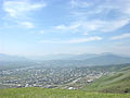
Ust-Koksa ( Russian Усть-Ко́кса , South Altai Кӧк-Суу Kök-Suu ) is a larger village (selo) in the Autonomous Republic of Altai ( Russia ) with 4,373 inhabitants (as of October 14, 2010).
geography
The place is at almost 1000 m above sea level in the Russian part of the Altai Mountains . It stretches on the left bank of the Koksa River , after which the place was named ( ustje Russian for “mouth”, Koksa Russified by the South Maltese Kök suu for “blue river”) to its confluence with the left Ob -spell river Katun . Its valley widens near Ust-Koksa to the Uimon steppe , a plateau that extends over 30 kilometers downstream in an easterly direction. Immediately to the north of the village, an extension of the Terekta ridge of the Altai rises to an altitude of about 2400 m .
Ust-Koksa is about 200 kilometers as the crow flies south of the republic capital Gorno-Altaysk . The village is the administrative center of the Rajons Ust-Koksa . The third largest Rajon of the republic in terms of area (12,910 km²) as well as number of inhabitants (17,524; calculation 2008) includes a total of 42 localities, which are combined into 9 rural settlements . The rural settlement of Ust-Koksa includes the small towns of Bashtala , Kastachta and Kurunda on the northwestern edge of the Uimon steppe, as well as Vlasjewo , Sini Jar , Tjugurjuk and Krasnoyarka , which are spread over about 25 km along the lower reaches of the Koksa.
The population consists mainly of Russians and Altai people .
history
Ust-Koksa was founded in 1807 by old-believing resettlers who withdrew from the Kuznetsk region before being persecuted by the Orthodox state church .
Population development
| year | Residents |
|---|---|
| 1939 | 1642 |
| 1959 | 1995 |
| 1970 | 2286 |
| 1979 | 2913 |
| 1989 | 3526 |
| 2002 | 3986 |
| 2010 | 4373 |
Note: census data
Culture and sights
Ust-Koksa is a tourist center for visiting the highest part of the Altai, the Katun ridge with the 4506 m high Belucha , the nature reserves in this area as well as rafting and canoeing on the Katun.
Infrastructure
The place is on the regional road R373 , which is asphalted only on shorter sections , which continues from Tuekta on the trunk road M52 ("Tschujatrakt") via Ust-Kan to the village of Tjungur . Since the continuation of the road from Tjungur along the left bank of Katun to Inja, which is about 70 km away and also on the M52, has not been carried out so far, road traffic, including public buses, has to take the detour via Ust-Kan and the Jabogan Take the pass ( 1492 m ) and the Kyrlyk pass ( 1471 m ). This increases the driving distance to the republic capital Gorno-Altaisk to almost 400 kilometers, double the direct distance.
In Ust-Koksa, a short road branches off from the R373, which opens up the villages of Berjosowka , Ognjowka , Kaitanak and Maralowodka on the left bank of the Katun .
A small airport ( ICAO code UNBU ) a good five kilometers east of the town, from which there was a connection to Gorno-Altaisk and Barnaul , has not been served as planned since 1995. A reconstruction and resumption of operations is under discussion.
In Ust-Koksa there are three schools, a hospital, a polyclinic , a cultural center and two hotels.
Ust-Koksa

Web links
- About the region: geography, economy
- Ust-Koksa on the tourist website turistka.ru (Russian)
Individual evidence
- ↑ a b Itogi Vserossijskoj perepisi naselenija 2010 goda. Tom 1. Čislennostʹ i razmeščenie naselenija (Results of the All-Russian Census 2010. Volume 1. Number and distribution of the population). Tables 5 , pp. 12-209; 11 , pp. 312–979 (download from the website of the Federal Service for State Statistics of the Russian Federation)