Turochak
| Village
Turotschak
Турочак
|
||||||||||||||||||||||||||||
|
||||||||||||||||||||||||||||
|
||||||||||||||||||||||||||||
Turotschak ( Russian Туроча́к ; South Maltese Турачак , Turachak ) is a village (selo) in the Altai Republic ( Russia ) with 5582 inhabitants (as of October 14, 2010).
geography
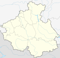
The place is about 90 km as the crow flies east-northeast of the republic capital Gorno-Altaisk in the northeastern part of the Russian Altai . It is located on the right bank of the Bija , between Bija and its right tributary Lebed , which flows a few kilometers below (north) the place.
Turochak is the administrative seat of the Turotschakski Rajons as well as the seat of the rural community Turochakskoje selskoje posselenije, which includes the villages of Kajaschkan, Lebedskoje, Sowetski Baigol, Stretinka and Ust-Lebed in addition to the village of Turochak.
history
The village was founded in 1864 and in 1922, with the establishment of the Oirot Autonomous Oblast, from which the present Altai Republic emerged, the administrative seat of Lebedinski aimak. In 1933 the aimak was renamed Turotschakski aimak , enlarged in 1962/1963 and, as is common in other parts of the Soviet Union , the administrative unit was converted into a Rajon .
Population development
| year | Residents |
|---|---|
| 1939 | 2052 |
| 1959 | 3331 |
| 1970 | 3633 |
| 1979 | 4325 |
| 1989 | 5080 |
| 2002 | 5484 |
| 2010 | 5582 |
Note: census data
traffic
Turotschak is located on the regional road R375, the 150 km from the well remote Bijsk on the right, the eastern side of the Bija up to about 70 km to the south of Turotschak lake teletskoye follows. In Turochak, a dirt road branches off from this into the area called Bergschorien in the neighboring Kemerovo Oblast , which first leads to Tashagol , about 100 km away , and then continues to Novokuznetsk .
Individual evidence
- ↑ a b Itogi Vserossijskoj perepisi naselenija 2010 goda. Tom 1. Čislennostʹ i razmeščenie naselenija (Results of the All-Russian Census 2010. Volume 1. Number and distribution of the population). Tables 5 , pp. 12-209; 11 , pp. 312–979 (download from the website of the Federal Service for State Statistics of the Russian Federation)


