Jägersburg (Eggolsheim)
|
Jägersburg
Eggolsheim market
Coordinates: 49 ° 44 ′ 47 ″ N , 11 ° 5 ′ 19 ″ E
|
|
|---|---|
| Height : | 361 (359-361) m above sea level NHN |
| Residents : | 83 (1987) |
| Postal code : | 91301 |
| Area code : | 09191 |
|
The Jägersburg district of Eggolsheim
|
|
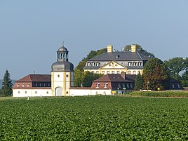
Jägersburg is a former hunting lodge that belongs to the Eggolsheim market .
geography
The former hunting lodge in the Erlanger Albvorland is one of 13 officially named parts of the municipality in the Upper Franconian market of Eggolsheim. Jägersburg is located about four kilometers southeast of the center of Eggolsheim at 361 m above sea level. NHN .
history
As a result of the administrative reforms in the Kingdom of Bavaria at the beginning of the 19th century , the former hunting lodge of the Counts of Schönborn became a part of the rural community of Bammersdorf with the second municipal edict in 1818 . In the course of the municipal territorial reform in Bavaria in the 1970s, the place was incorporated into the Eggolsheim market together with the municipality of Bammersdorf on July 1, 1972. In the second half of the 20th century there was a retirement home in Jägersburg , at that time the place had 83 inhabitants in 1987. After its use had been abandoned, the building complex was redesigned for event purposes.
Attractions
The hunting lodge, which was built in the 1720s according to plans by Anselm Franz von Ritter zu Groenesteyn , is a Baroque complex made up of several listed building parts, including a gate tower and a chapel in addition to the main building.
literature
- Ingomar Bog : Forchheim (= Historical Atlas of Bavaria, part of Franconia . I, 5). Komm. Für Bayerische Landesgeschichte, Munich 1955, DNB 450540367 ( digitized version ).
- Johann Kaspar Bundschuh : Jägersburg . In: Geographical Statistical-Topographical Lexicon of Franconia . tape 3 : I-Ne . Verlag der Stettinische Buchhandlung, Ulm 1801, DNB 790364301 , OCLC 833753092 , Sp. 2 ( digitized version ).
- Gertrud Diepolder : Bavarian History Atlas . Ed .: Max Spindler . Bayerischer Schulbuch Verlag, Munich 1969, ISBN 3-7627-0723-5 .
- Federal Statistical Office (Hrsg.): Historical municipality register for the Federal Republic of Germany. Name, border and key number changes in municipalities, counties and administrative districts from May 27, 1970 to December 31, 1982 . W. Kohlhammer, Stuttgart / Mainz 1983, ISBN 3-17-003263-1 .
Web links
- Bavarian authorities guide for Jägersburg , accessed on November 9, 2019
- Jägersburg in the BayernAtlas , accessed on November 9, 2019
- Jägersburg on a historical map , accessed on November 9, 2019
- Jägersburg in the Topographia Franconiae of the University of Würzburg , accessed on November 9, 2019.
Individual evidence
- ↑ a b Bavarian State Office for Statistics and Data Processing (Ed.): Official local directory for Bavaria, territorial status: May 25, 1987 . Issue 450 of the articles on Bavaria's statistics. Munich November 1991, DNB 94240937X , p. 301 ( digitized version ). Retrieved November 9, 2019
- ↑ a b Jägersburg in the location database of the Bavarian State Library Online . Bayerische Staatsbibliothek, accessed on November 9, 2019.
- ↑ Geographical location of Jägersburg in the Bayern Atlas , accessed on November 9, 2019
- ↑ Ingomar Bog : Forchheim (= Historical Atlas of Bavaria, Part Franconia . I, 5). Komm. Für Bayerische Landesgeschichte, Munich 1955, DNB 450540367 , p. 113 ( digitized version ).
- ^ Federal Statistical Office (ed.): Historical municipality directory for the Federal Republic of Germany. Name, border and key number changes in municipalities, counties and administrative districts from May 27, 1970 to December 31, 1982 . W. Kohlhammer, Stuttgart / Mainz 1983, ISBN 3-17-003263-1 , p. 682 .
- ^ Homepage of Schloss Jägersburg , accessed on November 9, 2019

