Kaltenbrunn (Mitwitz)
|
Kaltenbrunn
Mitwitz market
Coordinates: 50 ° 15 ′ 20 ″ N , 11 ° 15 ′ 4 ″ E
|
|
|---|---|
| Height : | 320 m above sea level NHN |
| Residents : | 85 (1987) |
| Incorporation : | 1st January 1974 |
| Postal code : | 96268 |
| Area code : | 09266 |
|
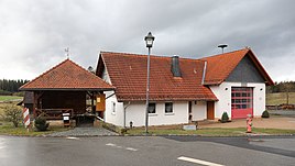
Fire station
|
|
Kaltenbrunn is part of the municipality of the Upper Franconian market Mitwitz in the Kronach district in Bavaria .
geography
The village is located about three kilometers northeast of Mitwitz and about eight kilometers northwest of the district town of Kronach on the border with Thuringia . The Lower Föritz flows past the village at the western foot of the Rotschreuther Berg. The state road 2708 connects Kaltenbrunn with Mitwitz and in the opposite east direction with Haßlach near Kronach . A community road leads from Kaltenbrunn to Burgstall .
history
The place name probably goes back to a flowing, clear source. According to the land register of the Bamberg bishopric from 1348, the towns of Rotschreuth, Kröttendorf and Kaltenbrunn were pledged to Wolfelin Zolner in Kronach. Kaltenbrunn was temporarily abandoned and in 1595 consisted of three whole and four half estates as well as a devastation. It belonged in the early modern period to the neck Court Mitwitz. During the Thirty Years' War Mitwitz and its neighboring towns suffered from repeated looting and murders.
As a result of the Reichsdeputation Hauptschluss , Kaltenbrunn became the property of the Electorate of Bavaria in 1806 . In 1813 the place had 49 inhabitants and 11 houses. As a result of the municipal edict of 1818, the rural community of Kaltenbrunn was established.
In 1862 the rural community was incorporated into the newly created Bavarian district office of Kronach . It consisted of nine places, the village of Kaltenbrunn as the main town and the two hamlets of Bächlein and Neubau as well as the six wastes of Bätzwustung, Froschgrün, Haderleinswustung, Krötendorfswustung, Schaumbergswustung and Veitenwustung. In 1871 the main town had 84 inhabitants. The Protestant church was in Mitwitz, 3.5 kilometers away, and the Protestant denominational school in Burggrub, 4.5 kilometers away. In 1900, the 571 hectare rural community had 186 residents, 39 of whom were Catholic and 147 Protestant, and 33 were residential buildings. The Catholics belonged to the Mitwitz Castle Curate. The main town had 63 residents and 13 residential buildings. The Protestant school responsible was in Mitwitz and the Catholic school in Haig, 4.0 kilometers away . In 1925, 207 people lived in the rural community, 89 of them in the village of Kaltenbrunn in 16 residential buildings. The evangelical school was in town.
After the Second World War , the location on the inner-German border shaped the town until 1989 .
In 1950 the community of Kaltenbrunn had 252 inhabitants. The main town had 99 inhabitants with 15 residential buildings. The Catholics belonged to the district of the Schlosskuratie in Mitwitz. In 1961, 93 people lived in 18 residential buildings in Kaltenbrunn. In 1970 the main town had 101 inhabitants and in 1987 85 inhabitants and 20 residential buildings with 28 apartments.
In the course of the regional reform in Bavaria , the municipality of Kaltenbrunn was incorporated into Mitwitz on January 1, 1974.
Architectural monuments
In the Bavarian Monument List , a residential stable house is listed as an architectural monument.
Web links
Individual evidence
- ↑ a b Bavarian State Office for Statistics and Data Processing (Ed.): Official local directory for Bavaria, territorial status: May 25, 1987 . Issue 450 of the articles on Bavaria's statistics. Munich November 1991, DNB 94240937X , p. 311 ( digitized version ).
- ^ A b Rudolf Pfadenhauer and Heinz Köhler : 750 years of Mitwitz, documentation on the history of Mitwitz and Neundorf. Markt Mitwitz 2016, p. 23.
- ^ Rudolf Pfadenhauer and Heinz Köhler : 750 years of Mitwitz, documentation on the history of Mitwitz and Neundorf. Markt Mitwitz 2016, p. 136.
- ↑ Kgl. Statistical Bureau (ed.): Complete list of localities of the Kingdom of Bavaria. According to districts, administrative districts, court districts and municipalities, including parish, school and post office affiliation ... with an alphabetical general register containing the population according to the results of the census of December 1, 1875 . Adolf Ackermann, Munich 1877, 2nd section (population figures from 1871, cattle figures from 1873), Sp. 1060 , urn : nbn: de: bvb: 12-bsb00052489-4 ( digital copy ).
- ↑ K. Bayer. Statistical Bureau (Ed.): Directory of localities of the Kingdom of Bavaria, with alphabetical register of places . LXV. Issue of the contributions to the statistics of the Kingdom of Bavaria. Munich 1904, Section II, Sp. 1055 ( digitized version ).
- ↑ Bavarian State Statistical Office (ed.): Localities directory for the Free State of Bavaria according to the census of June 16, 1925 and the territorial status of January 1, 1928 . Issue 109 of the articles on Bavaria's statistics. Munich 1928, Section II, Sp. 1089 ( digitized version ).
- ↑ Bavarian State Statistical Office (ed.): Official place directory for Bavaria - edited on the basis of the census of September 13, 1950 . Issue 169 of the articles on Bavaria's statistics. Munich 1952, DNB 453660975 , Section II, Sp. 938 ( digitized version ).
- ↑ Bavarian State Statistical Office (ed.): Official city directory for Bavaria, territorial status on October 1, 1964 with statistical information from the 1961 census . Issue 260 of the articles on Bavaria's statistics. Munich 1964, DNB 453660959 , Section II, Sp. 690 ( digitized version ).
- ^ Bavarian State Statistical Office (ed.): Official place directory for Bavaria . Issue 335 of the articles on Bavaria's statistics. Munich 1973, DNB 740801384 , p. 159 ( digitized version ).
- ^ Rudolf Pfadenhauer and Heinz Köhler : 750 years of Mitwitz, documentation on the history of Mitwitz and Neundorf. Markt Mitwitz 2016, p. 21.

