
Chapel Shore
| Chapel Shore | |
|---|---|
|
|
|
 |
|
| Wall marking on the chapel bank | |
| Basic data | |
| place | Berlin |
| District | center |
| Created | around 1871 |
| Newly designed | May 31, 1951, 2005-2006 |
| Hist. Names | Friedrich-Karl-Ufer |
| Connecting roads |
Rahel-Hirsch-Strasse (west) , Schiffbauerdamm (east) |
| Cross streets |
Alexanderufer , Unterbaumstrasse , Reinhardtstrasse |
| Buildings | see buildings |
| use | |
| User groups | Pedestrian traffic , bicycle traffic , car traffic , public transport |
| Technical specifications | |
| Street length | 250 meters |
The chapel-shore is a street at the northern Spree -Ufer in Berlin district of Mitte . It is named after the resistance fighter Heinz Kapelle (1913–1941).
history
From May 13, 1871 to 1951, the street was named Friedrich-Karl-Ufer after the Prussian Prince and Field Marshal Friedrich Karl Nikolaus (1828-1885). After the end of the Second World War , the road was right on the border from the Soviet to the British sector of Berlin. The renaming of the eastern part of the 1941 executed communist resistance fighters took place on May 31, 1951. The reclassification was in the context of a concerted renaming action by the SED -dominated East Berlin magistrate at the World Festival of Youth that took place in August 1951 in Berlin . 168 remaining place and street names in the Soviet sector of the city with military or monarchical reference have been changed.
Part of the street is shaped by the course of the Berlin Wall . In February 1968, the couple Elke and Dieter Weckeiser were shot while trying to escape .
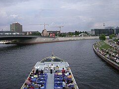
During the construction of the bond of the covenant , the designed landscape architecture office Group F to the promenade. Around 4000 m² of granite stone were built in and 30 historical benches were set up, which allow a view of the Chancellery , the Moltke Bridge and Berlin Central Station . It was inaugurated on May 11, 2006.
Todays use
The street Kapelle-Ufer, which was released on May 9, 2005, was part of a development measure “Capital Berlin - Parliament and Government District”. In connection with Rahel-Hirsch-Straße and Hugo-Preuß-Brücke , the street serves the northern bypass of the government district . At the same time here is done on the development of Berlin's central station and the Schiffbauerdamm .
Buildings
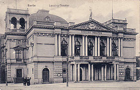
- The Lessing Theater on Friedrich-Karl-Ufer 1 / corner of Unterbaumstrasse , inaugurated in 1888 , was destroyed by bombs in 1945 .
- The AEG had in 1906 completed house Friedrich-Karl-Ufer 2-4 their corporate headquarters. The building designed by Alfred Messel was destroyed in World War II.
- The district office of the Niederbarnim district was located in the Nieder-Barnimer district building, Friedrich-Karl-Ufer 5. This building was also destroyed in the Second World War.
- The " Federal Press Beach " was on the Kapelle-Ufer until the end of 2011. However, the city beach had to give way to the new building of the Federal Ministry of Education and Research (BMBF), which was moved into in autumn 2014. As the first civil federal building, it was planned, built and financed in a public-private partnership (PPP).
- To the north of the new BMBF building, the Futurium has been built, the foundation stone of which was laid in 2015 and which opened its doors to the public on September 5, 2019. When an urban planning concept was drawn up on behalf of the Federal Office for Building and Regional Planning in 2009, research-related institutions were to find a place on the area according to the BMBF's ideas. The state of Berlin, on the other hand, preferred residential use. After the federal election in autumn 2009, the Union and FDP agreed in a coalition agreement on the house in which Germany would present itself as “a knowledge society and innovation driver”.
- The federal press conference is located at the southern end on Schiffbauerdamm .
- At the northern end stands at Alexanderufer to Humboldthafen out the new commercial building HumboldtHafenEins , the accounting firm in the 2015 PricewaterhouseCoopers and the Germany headquarters of the pharmaceutical company Sanofi Pasteur MSD will move as a tenant.
- The view of the Federal Band with the Paul-Löbe-Haus and the Chancellery, the Spree and the Spreebogenpark as well as the Berlin Central Station is worth seeing .
- Buildings on the chapel bank
Lessing Theater
destroyed around 1910 1945
Federal Press Beach (2009)
Kapelle-Ufer (2010)
left: Hugo-Preuss-Brücke
BMBF headquarters (2014)

"SpreeEck" office building
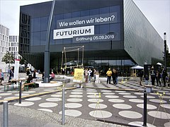
Project building Futurium


.jpg)

Web links
- Chapel Shore. In: Street name lexicon of the Luisenstädtischer Bildungsverein (near Kaupert )
- Development plan for the Kapelle-Ufer. On stadt-berlin.de , accessed on February 1, 2012. ( JavaScript required)
Individual evidence
- ^ Friedrich-Karl-Ufer . In: Street name lexicon of the Luisenstädtischer Bildungsverein
- ↑ Johanna Sänger: Hero cult and love of home: street and honorary names in the official memory of the GDR . Ch. Links Verlag, 2006, ISBN 978-3-86153-398-6 , p. 103 f . ( google.de [accessed on August 5, 2019]).
- ↑ Dieter and Elke Weckeiser's failed attempt to escape (Kapelle-Ufer). From: 50jahremauerbau.de , accessed on February 2, 2012.
- ↑ Kapelle-Ufer Berlin. ( Page no longer available , search in web archives ) Info: The link was automatically marked as defective. Please check the link according to the instructions and then remove this notice. From: doerriesgalabau.de , accessed on February 1, 2012.
- ↑ Chapel embankment open to traffic and designation Hugo-Preuß-Brücke. From: stadtentwicklung.berlin.de , accessed on February 1, 2012.
- ↑ Photos of the AEG administration building on Friedrich-Karl-Ufer in the German Digital Library , accessed on November 26, 2014.
- ↑ New Berlin office At: Federal Ministry of Education and Research , accessed on November 26, 2014.
- ↑ Spreebogen-Kapelleufer: Urban planning report 2009. From : as-if.info , accessed on February 2, 2012.
- ↑ Official offices instead of federal press beach In: Berliner Zeitung , March 17, 2010, accessed on November 26, 2014.
- ↑ In the spring of 2015, the tenants move to Humboldt-Hafen-Eins ( Memento of the original from December 5, 2014 in the Internet Archive ) Info: The archive link has been inserted automatically and has not yet been checked. Please check the original and archive link according to the instructions and then remove this notice. In: Berliner Woche , September 22, 2014, accessed on November 26, 2014.
- ↑ Corner of Kapelle-Ufer / Reinhardtstrasse
Coordinates: 52 ° 31 '23.3 " N , 13 ° 22' 29.2" E