
Karaböcülü
Coordinates: 36 ° 27 ′ 14.4 " N , 33 ° 54 ′ 56.7" E


Karaböcülü is the Turkish name for the ruins of an ancient settlement in Rough Cilicia in southern Turkey , which was inhabited from the late Hellenistic to the early Byzantine period.
location
Karaböcülü is located near the hamlet Çamlıbel - whose former name was Karaböcülü - in the Silifke district of the Mersin province , about ten kilometers north of the district center and 75 kilometers southwest of the provincial capital Mersin . Two roads lead north from Silifke towards Uzuncaburç , the ancient Olba . The western stretch forms an arc and meets the eastern stretch in İmamlı . About halfway it passes Karaböcülü, and then just before İmamlı it passes the Roman villa of Gökkale . Karaböcülü is located at a height of about 600 meters on a crest that slopes steeply on three sides above the deeply cut valley of Kanlı Dere , which flows not far south into the Göksu , the ancient Kalykadnos.
description

50 to 60 houses were distributed over an area of 300 × 300 meters. They stood close together and formed small alleys that did not follow any given pattern. The walls, of which only sparse remains have been preserved, were largely made of double-shell polygonal masonry with a filling of stone fragments. The floor plans of the probably only single-storey houses are multi-room and designed differently. Younger houses, presumably from the imperial era , have the inner belt arches typical for the area and presumably had isodomous outer walls, of which, however, very little is left. In contrast to the house walls, which have largely disappeared due to stone robbery and erosion, there are still numerous monolithic door frames with mighty lintels in situ . Many of them bear Olbic characters in high relief, including especially clubs and a phallus . Some of the houses are equipped with peristyles , consisting of Doric , non-fluted columns and fascia architraves . There are individual oil presses distributed between the houses as well as cisterns under each house, some of which are of considerable size. The latter represented the exclusive water supply of the place and are partly used again by today's residents.
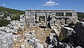
The remains of an early Byzantine basilica lie between the houses in the village . The two-aisled building has a length of 23 meters including the narthex and an apse protruding to the east and is 11 meters wide. The narthex in the west measures three meters. The main nave has a 4.30 meter wide apse, which was pierced at the top by an arched window and enclosed on the outside by a straight choir closure . The smaller, north aisle ends in an apse protruding over the east wall, which is why the archaeologists Friedrich Hild and Hansgerd Hellenkemper , who visited the place in 1985, assumed a side chamber there next to the choir. The ships were probably separated by a row of columns, a single column of which has been preserved. The entire structure is made of carefully crafted ashlar blocks with thin mortar joints.
In the north the place is enclosed in a semicircle by a necropolis , which consists of fixed sarcophagi and chamosoria . To the northeast, where the ancient road - as well as the modern one - met the place, there are two remarkable funerary monuments. One is a sarcophagus vaulted by an arcosol arch , the other is a burial temple facing east. The grave temple stands on a base made of cuboids with protruding profiles at the top . The inside of the cella is unadorned. Outside, the corners and the protruding ante are decorated with pilasters , which are crowned by Corinthian capitals . Above this, an entablature runs around the building, consisting of architraves with three fascias (horizontal stripes), above a profile, a simple, swinging frieze and a protruding console entablature. The pillars of the portico have broken out. The gable has crashed, from a medallion there with the relief of a married couple, the part with the bust of the woman is now in front of the temple front. The monument can be dated to the 2nd to 3rd centuries AD. Similar grave structures can be found more often in the region between the coast and the Olbian highlands.
The Olbic symbols indicate that the village belongs to the Hellenistic priestly state of Olba. Karaböcülü is thus the westernmost place that is assigned to the territory of Olba. The signs prove that the place existed as early as the late Hellenistic period in the 1st century BC. The construction of the later houses suggests the Roman imperial era, the church and individual cross symbols show that the settlement was inhabited at least until the early Byzantine period.

Lintels with olbic clubs
House walls

Apse wall of the church, surrounded by Turkish house walls

Woman bust from the gable of the burial temple


literature
- Friedrich Hild , Hansgerd Hellenkemper : Kilikien and Isaurien. Tabula Imperii Byzantini Volume 5. Verlag der Österreichischen Akademie der Wissenschaften, Vienna 1990, ISBN 3-7001-1811-2 , p. 288.
- Hansgerd Hellenkemper, Friedrich Hild: New research in Kilikien. Publications of the commission for the Tabula Imperii Byzantini Volume 4. Verlag der Österreichischen Akademie der Wissenschaften, Vienna 1986, ISBN 3-7001-0771-4 , pp. 52–54.
Web links
Individual evidence
- ↑ Serra Durugönül : Towers and Settlements in Rough Cilicia. Asia Minor Studies Volume 28. Rudolf Habelt, Bonn 1998, ISBN 3-7749-2840-1 , p. 89.