
Visegrád-Sibrik Castle
| Visegrád-Sibrik Castle | |
|---|---|
| Alternative name | Pone Navata ? |
| limes | Pannonian Limes |
| section | 3 |
| Dating (occupancy) | a) fortress: Constantine (late 20s) or 50s / 60s of the 4th century abandoned before 380; b) Burgus : until the fall of the province |
| Type | late antique fortress |
| unit | Auxilia Ursarensia |
| size | 114 × 130 m |
| Construction | stone |
| State of preservation | Remains visible in the area |
| place | Visegrád |
| Geographical location | 47 ° 47 '53.5 " N , 18 ° 58' 48.3" E |
| height | 175 m |
| Previous | Burgus Visegrád-Lepence (southwest) |
| Subsequently |
Small fort Kisoroszi (northeast) Fort Dunabogdány - Cirpi (southeast) |

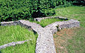
The Visegrád-Sibrik fort , probably called Pone Navata in antiquity , is a former Roman military camp which, as a border fortress in late antiquity, was responsible for guarding a section of the Danube in the Pannonian Limes . The river formed the Roman frontier in large sections. The partially excavated and made visible fort is located on the Sibrik hill belonging to the Visegrád Mountains near Visegrád (Plintenburg) in the Hungarian Pest county . The Roman enclosing walls were still in use in the high Middle Ages.
location
The system was built on the rounded, trapezoidal plateau of the Sibrik Hill, 176 meters above the Danube, making the best use of the existing topographical conditions. To the southwest, it was possible to have a long view as far as the sliding slope of the Danube Bend winding there to the north. To the northeast, the soldiers could still observe the northern tip of the large Danube island Szentendrei (Sankt-Andrä-Insel) . At this point, the eastern arm of the river, which was already broader in ancient times, separates from its western, mostly parallel-flowing junction, which stretches southwards near the Pilis Mountains. The Romans included the island and the eastern bank of the eastern arm of the Danube in their surveillance system during late antiquity, which, in addition to Ländeburgi, is shown by the work on the advanced fort Göd-Bócsaújtelep . The bank opposite the Visegrád-Sibrik fort was Barbaricum . There was a late Roman watchtower at another point further west at the inlet of the Eipel , but also on the opposite bank, so that there is at least a more or less regular presence of troops. The Pannonian Danube Limes is often called Ripa (Latin for bank ) in Hungarian research .
Research history
The fort probably got its current name with Slavic settlers in the 9th century. Visegrád means high castle . The first written mention was made in 1009. The knowledge of the old populated square, which formed the nucleus of the place Visegrád, which is so important for Hungarian history, was preserved for a long time in a mighty Valentine tower, which was repaired in the Middle Ages, in addition to the Roman defensive wall that was still in use . Research assumes that King Solomon , the adversary of King Ladislaus I , was imprisoned in this tower around 1080 due to disputes over the throne. The Solomon's Tower , known for it in the past , the core building of a medieval bastion in the defense concept of the royal castle complex of Visegrád, was only built in the 13th century. Roman stone monuments were recovered in Visegrád as early as the 19th century, for example in 1894 in the “Várkert” corridor (castle garden). The almost unbuilt fort square was partially excavated from 1951 to 1952, 1954 and 1970 to 1975 by Sándor Soproni (1926–1995) and Mátyás Szőke. This was followed by the restoration and conservation of a section of the wall and the post-castle tower. In 1955, Soproni carried out a partial exploration of the Schlossgarten corridor to the east, on the plot numbered 2558, and found a Villa Rustica with an irregular floor plan and remains of wall paintings. Roman graves were also discovered near the citadel of Fellegvár and also in the corridor of the castle garden.

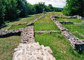
The Sibrik hill with the restored remains of the fort's foundations

Visegrád - right on the mountain: The ruins of the Fellegvár (Upper Castle) from the 12th century; in the depression between the right and left mountain, the "Solomon Tower" from the 13th century; between this tower and the rearmost mountain was the "high castle" - the fort on the smaller hill

Attempt to reconstruct the complex in the post-Valentine era (3rd phase)

A plaque erected at the fort for the 1000th anniversary of Visegrád in 2009, which shows the ancient and medieval findings as well as the first Visegrád church in the Danube valley.

View from the southwest onto the fort area - the Danube in the background

View over the fort area in south direction to the Visegrad Mountains

_6.jpg)


Building history
I. phase


The late Roman fortification, around 114 × 130 meters in size, was built with an irregular floor plan typical of the time, which takes the height of the Sibrik hill in the form of a dragon square. The wall thickness of the fence was 1.1 to 1.2 meters, the closely spaced side towers had a horseshoe-shaped basic shape, while the corner towers were fan-shaped. No building traces could be found inside. Smaller rooms were only built on the inside of the wall. After Soproni, to the east was the only gate with two passages, possibly flanked by two horseshoe-shaped towers. The archaeologist Endre Tóth doubted this, pointing out that the location of the gate is still unknown today.
Soproni determined the founding time of the facility on the basis of 50 coins that were found during the partial excavation of the defensive wall at the end of the 20s of the 4th century. With regard to fortifications from late antiquity, he hypothesized that all of the fan-shaped and horseshoe-shaped towers known in Pannonia can be dated to the reign of Constantine (306–337) , especially with regard to Visegrád – Sibrik . The archaeologist András Mócsy followed this opinion . However, the age of the fort cannot be inferred from the excavation observations published at the time. Overall, Soproni's idea is controversial. The horseshoe-shaped towers in Visegrád-Sibrik have a very pressed arch shape as a special feature. This typical building feature is rarely found in Pannonia: for example at the Klosterneuburg Castle , in Szentendre and in Nagytétény . The archaeologist Zsolt Visy assumes, in view of the more recent research results that were available up to the first decade of the 21st century, that Visegrád-Sibrik was created much later, in the 50s and 60s of the 4th century.
2nd phase
The previous intermediate tower on the eastern front of the fort on the Danube side was demolished. A double gate was built in its place. According to Soproni, this gate system is said to have been rebuilt during the reign of Emperor Constantius II (337–361). He suspected that the gate towers were demolished. These considerations are being put to the test today.
3rd phase
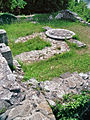
After the death of Emperor Valentinian I in 375, the fort was possibly abandoned (before 380) and his occupation force, the Auxilia Ursarensia , according to Notitia dignitatum , moved to Ad Statuas (Várdomb) . The reason for this lay in the significant loss of importance of the location on the Sibrik Hill after the abandonment of the great rampart system around 378, which had been pushed far into the Hungarian lowlands and formed a buffer zone for the Pannonian provinces behind the Danube. This necessitated a higher concentration of troops on the now directly threatened eastern border of the province along the Danube, which flows from north to south. The fortification was possibly used as a small guard post, a reliable proof of this assumption is impossible due to the later extensive destruction of the ancient ground level. The new crew erected a mighty square burgus at the presumed location of the gate , which had an inner diameter of 11.75 × 11.75 meters. This was in use until the province was abandoned. Its ruins were apparently well preserved and clearly visible until the 11th century - when its masonry was renewed.
During the excavations from 1974 to 1975, the archaeologists came across the fence in the fan-shaped tower at the northeast corner and in the opposite area on the brick stamp of Terentius Dux , who, according to evidence of two watchtowers on the Danube bend, apparently held the official duties in the province until 371. Possible construction or repair work shortly before the plant is abandoned is connected to the bricks.
- Structural condition and findings
Restored foundation of the southeast tower
The south wall of the fort; on the right a medieval installation from around 1050 overlaying the Roman foundations.

Post-Valentine tower that was built in the area of the presumed fort entrance.
Construction stages on top of each other in the tower

Inside the post-Valentine tower

The mighty, later built tower as an ideal reconstruction in the ground plan


Finds and Findings
As with other Pannonian Limes forts from late antiquity, ceramics decorated with plastering was found during the excavations of the 1970s on the Sibrik Hill, among other things in two of a total of three uncovered pit houses and in a waste pit, which may have been brought with them by newly arrived settlers and, for example, in the likewise late Roman small fort Pilismarót – Malompatak was also made. However, there is also the possibility that the late pieces decorated with smoothing produced a barbaric population observed in late antiquity. In addition to the smoothing ceramics, rough, hand-shaped barbaric vessels and unglazed, clay-ground provincial Roman pieces emerged from the ground. Another type of ceramic was ceramic with a smooth surface, as can also be found on hand-formed vessels. Endre Tóth mentions the smoothed grid pattern ceramic in connection with the finds from the two residential pits and the waste pit.
The general discussions about the exact age determination of the glazed goods are still going on after it has been established that this ceramic appears in the finds from the first half of the 4th century. This is contrary to older research, since smoothing ceramics are dated more recently. Herbert Mitscha-Märheim lists them as pure so-called Foederatenkeramik . Research describes barbaric mercenaries as Foederati , who were often responsible for border security in the late and end of the Limes.
The old finds from Visegrád include some altar stones, such as the badly damaged piece, which was already mentioned above and found in 1894, which is dated to the 3rd century.
The most important ancient legacies in the area around the fort include river finds , which come to light below the Roman fortifications during the repeatedly necessary dredging of the Danube bed. A particularly important piece was the 12.7 centimeter high bronze bust of a satyr or Silenus found near Kismaros , which, however, cannot be associated with the fort despite its proximity. The piece shows the face of a young satyr on one side, like the head of a Janus, and that of an old one on the other. The sculpture is dominated by a total of four phalluses , which are differently erect and which also take up the contrast between young and old and these two faces sit on the imaginary dividing line. One ear is also shaped like a phallus, while the other shows the typical pointed satyr shape, but pointing 180 degrees downwards. The neck is engraved with a fertility mark.
Lost property
Finds from the excavations, especially stone monuments, but also the river finds from the Danube are in the Mátyás Király Múzeum (King Matthias Museum) in Visegrád, others are exhibited in the Salomon Tower Museum.
Limes course between Visegrád – Sibrik to Kisoroszi
| route | Name / place | Description / condition |
|---|---|---|
| 3 | Visegrád-Várkert (Burgus Solva 26) |
In the corridor of the Schlossgarten, a Limes watchtower from the reign of Emperor Commodus (180-192) was excavated by Sándor Soproni in 1962–1963 at the foot of the Sibrik Mountain, directly on the banks of the Danube . According to the findings, the tower was surrounded by three smaller trenches. It was found that this sentry post was repaired around 230 and finally destroyed around 270. There was no late antique Burgus successor at this point. The finds on the tower include brick stamps of the Legio II Adiutrix stationed in Aquincum and the Cohors (milliaria) Nova Surorum. This cohort has been recorded as an ancestral unit in the Szentendre Fort further south since around AD 175 . A bronze female face mask was also found .
Soproni touched on the above-mentioned Roman Villa Rustica nearby. A Roman inscription came to light there along with graves in 1955. Another inscription was found in the same corridor in 1894 as a spoil during excavations at the former basilite monastery. This monastery was founded by the Hungarian King Andrew I (1046-1060). In addition, from the 9th to the 11th century there was an Arpad period settlement in the castle garden and a deanery church with a cemetery. The investigation of the graves around this church brought to light finds from the 11th, 12th and 13th centuries. |
| 3 | Visegrád-Kisvillám (Burgus Solva 27) | The watchtower was located at the foot of the valley running east from the Kisvillám brook opposite the northern tip of the Danube island Szentendrei and was destroyed during road works from 1962 to 1963. It is possible that the wooden tower belonged to the earliest phase of the 2nd century. |
| 3 | Visegrád-Szentgyörgypuszta (Burgus Solva 28) | The Burgus Visegrád-Szentgyörgypuszta 1 was built on the rock of a small hill that slopes steeply to the north to the bank of the Danube and connects to the slope of the Mogyoróhegy in the south. In 1955 Soproni carried out an exploration with five search trenches. Inside, the system measured 9.35 meters to the north-south and 9.15 meters to the east-west and had a thickness of 1.05 meters in the rising masonry. The outer dimensions of the burgus built from locally occurring andesite in Opus incertum were 10.40 × 10.20 meters. Brick stamp of Caris trb. (Caris tribunus) and the Frigeridus dux testify to a development under the rule of Valentinian I. Frigeridus officiated between 371 and 373 AD as Dux Valeriae ripensis (military leader of the province of Valeria). Today nothing can be seen of the structural remains. However, the tower hill is clearly visible in the terrain. |
| 3 | Visegrád-Szentgyörgypuszta (Burgus Solva 29) | The Burgus Visegrád-Szentgyörgypuszta 2 was 300 to 400 meters southeast of the aforementioned facility on the southeast bank of the Kisvíllám brook, which forms the municipality boundary between Visegrád and Dunabogdány. Immediately south of the main street, Roman building remains were cut in 1970 during sewer work. The square residential and watchtower built in Opus incertum with its 1.2 meter thick walls probably stood in an inner courtyard surrounded by a wall. The coins recovered from this site point to an origin under Emperor Valentinian I. Soproni also mentioned small bronzes from the 4th century as a further find. |
| 3 | Kisoroszi (small fort) | On the opposite bank is the Danube Island Szentendrei. There, on a flood-proof small hill, was the little known and invisible small fort Kisoroszi . |


Monument protection
The monuments of Hungary are protected under the Act No. LXIV of 2001 by being entered in the register of monuments. The Visegrád-Sibrik fort as well as all other Limes facilities belong to the nationally valuable cultural property as archaeological sites according to § 3.1. According to § 2.1, all finds are state property, regardless of where they are found. Violations of the export regulations are considered a criminal offense or a crime and are punished with imprisonment for up to three years.
See also
literature
- Jenő Fitz (Ed.): The Roman Limes in Hungary (= Bulletin du musée roi Saint Etienne. Series A, Volume 22). Fejér Megyei Múzeumok Igazgatósága, Székesfehérvár 1976.
- Ulrich Brandl: Card 6: Brick stamp distribution of the Legio II Adiutrix. In: ders .: Investigations into the brick temples of Roman legions in the north-western provinces of the Imperium Romanum. Catalog of the Julius B. Fritzemeier Collection. Lidorf, Rahden 1999, ISBN 3-89646-173-7 , p. 68, no. 9.
- Zsolt Mráv : The building board of a shrine from Visegrád. To complement the inscription RIU. 815. 306. In: Antaeus. Communicationes ex Instituto archaeologico Academiae scientiarum Hungaricae . Volume 24, Budapest 1998, pp. 306-310.
- Sándor Soproni : A Roman watchtower near Szent-györgy-puszta, Visegrád. In: Studia Comitatensia I. 1972. pp. 39-43 (in Hungarian).
- Sándor Soproni, Mátyás Szőke: Visegrád-Sibrik domb (Kom. Pest) . In: Archaeologiai Értesítő , 104, 1977, p. 267.
- Sándor Soproni: The late Roman Limes between Esztergom and Szentendre. Akadémiai Kiadó, Budapest 1978, ISBN 9630513072 .
- Sándor Soproni: The last decades of the Pannonian Limes . CH Beck, Munich 1985, ISBN 3406304532 .
- Zsolt Visy : The Pannonian Limes in Hungary . Theiss, Stuttgart 1988, ISBN 3806204888 .
- Zsolt Visy, Endre Tóth , Dénes Gabler , László Kocsis , Péter Kovács u. a .: From Augustus to Attila - life on the Hungarian Danube Limes. Theiss, Stuttgart 2000, ISBN 3806215413 (publications of the Landesmuseum Aalen 53).
- Zsolt Visy: The ripa Pannonica in Hungary. Akadémiai Kiadó, Budapest 2003, ISBN 963-05-7980-4 , p. 52.
- Zsolt Visy: Definition, Description and Mapping of Limes Samples. CE Project "Danube Limes - UNESCO World Heritage" 1CE079P4. Budapest 2010. pp. 22-23.
Web links
Remarks
- ^ Zsolt Visy: Definition, Description and Mapping of Limes Samples. CE Project "Danube Limes - UNESCO World Heritage" 1CE079P4. Budapest 2010. pp. 22-23; here: p. 22.
- ↑ Jenő Fitz (ed.): The Roman Limes in Hungary. Fejér Megyei Múzeumok Igazgatósága, 1976. p. 8.
- ↑ Jenő Fitz (ed.): The Roman Limes in Hungary . Fejér Megyei Múzeumok Igazgatósága, 1976, p. 65.
- ↑ Endre Tóth : The late Roman military architecture in Transdanubia . In Archaeologiai Értesitő 134 . Budapest 2009. p. 41.
- ^ Zsolt Visy: The Pannonian Limes in Hungary . Konrad Theiss Verlag, Stuttgart 1988, ISBN 3806204888 . Pp. 72-73.
- ↑ Endre Tóth: The late Roman military architecture in Transdanubia . In Archaeologiai Értesitő . 134, Budapest 2009, p. 51.
- ↑ Endre Tóth: The late Roman military architecture in Transdanubia . In Archaeologiai Értesitő. 134, Budapest 2009, p. 48.
- ^ Zsolt Visy: A római Limes Magyarországon - The Roman Limes in Hungary. Brochure, 2008. p. 23.
- ↑ a b Zsolt Visy: The Pannonian Limes in Hungary . Konrad Theiss Verlag, Stuttgart 1988, ISBN 3806204888 , p. 73.
- ^ Sándor Soproni: The late Roman Limes between Esztergom and Szentendre. Akadémiai Kiadó, Budapest 1978, ISBN 9630513072 , p. 163.
- ^ Sándor Soproni: The last decades of the Pannonian Limes . CH Beck, Munich 1985, ISBN 3406304532 , p. 59.
- ↑ Burgus Visegrad Sibrik at 47 ° 47 '53.95 " N , 18 ° 58' 45.63" O .
- ^ Sándor Soproni: The last decades of the Pannonian Limes . Beck, Munich 1985, ISBN 3406304532 , p. 63.
- ^ Sándor Soproni: The last decades of the Pannonian Limes . CH Beck, Munich 1985, ISBN 3406304532 , p. 44.
- ↑ Manfred Kandler (Ed.): The Roman Limes in Austria. A leader . 2nd, unchanged edition. Publishing house of the Austrian Academy of Sciences, Vienna 1989, ISBN 3-7001-0785-4 , p. 31.
- ^ Sándor Soproni: The last decades of the Pannonian Limes . CH Beck, Munich 1985, ISBN 3406304532 , p. 51.
- ^ Endre Tóth: Karpen in the province of Valeria. On the question of late Roman smoothed ceramics in Transdanubia In: Communicationes archeologicae Hungariae . Múzsák KozművelŰdesi Kiadó, Budapest 2005. p. 382.
- ↑ Katalin Ottományi : Késő római besimított kerámia Nagykanizsán. In: Zalai Gyűjtemény No. 18, 1982-83, pp. 45-58 (in Hungarian).
- ↑ Herbert Mitscha-Märheim: Dark centuries of golden traces (The Migration Period in Austria). Wollzeilen publishing house, Vienna 1963.
- ↑ a b Sándor Soproni: Satyr-Silenus bronze head with master's name from Visegrád. In: Folia archaeologica . 41, Budapest 1990, p. 43.
- ↑ Route = numbering follows Zsolt Visy: The Pannonian Limes in Hungary (Theiss 1988) and Zsolt Visy: The ripa Pannonica in Hungary (Akadémiai Kiadó 2003).
- ↑ Jenő Fitz (ed.): The Roman Limes in Hungary . Fejér Megyei Múzeumok Igazgatósága, 1976, p. 59.
- ^ Sándor Soproni: The late Roman Limes between Esztergom and Szentendre. Akadémiai Kiadó, Budapest 1978, ISBN 9630513072 , p. 59.
- ↑ a b c d Zsolt Visy: The ripa Pannonica in Hungary. Akadémiai Kiadó, Budapest 2003, ISBN 9630579804 , p. 52.
- ↑ Jenő Fitz u. a .: The Roman inscriptions of Hungary (RIU). Savaria, Scarbantia and the Limes route Ad Flexum - Arrabona. 1. Delivery. Akadémiai Kiadó, Budapest 1972, p. 172.
- ↑ Jenő Fitz u. a .: The Roman inscriptions of Hungary (RIU). Savaria, Scarbantia and the Limes route Ad Flexum - Arrabona. 1. Delivery. Akadémiai Kiadó, Budapest 1972, p. 174.
- ^ Ágnes Sós: The Slavic population of western Hungary in the 9th century. Beck Verlag, Munich 1973, ISBN 340600492X , p. 156.
- ↑ a b c Sándor Soproni: The late Roman Limes between Esztergom and Szentendre. Akadémiai Kiadó, Budapest 1978, ISBN 9630513072 , p. 60.
- ↑ Burgus Solva 28 at 47 ° 48 '15.7 " N , 18 ° 59' 53.2" O .
- ↑ Jenő Fitz (ed.): The Roman Limes in Hungary. Fejér Megyei Múzeumok Igazgatósága, 1976, p. 67.
- ↑ fortlet Kisoroszi at 47 ° 48 '34.65 " N , 19 ° 0' 3.83" O .
Esztergom-Hideglelőskereszt Castle | Burgus Szob | Burgus Pilismarót-Malompatak | Castra ad Herculem | Visegrád-Gizellamajor small fort | Burgus Visegrád-Lepence | Visegrád-Sibrik Castle (Pone Navata) | Small fort Kisoroszi | Burgus Verőcemaros-Dunamező | Dunabogdány Castle (Cirpi) | Burgus Tahitótfalu-Balhavár