Oberkurzheim
| Oberkurzheim ( former municipality ) | ||
|---|---|---|
|
|
||
| Basic data | ||
| Pole. District , state | Murtal (MT), Styria | |
| Judicial district | Judenburg | |
| Pole. local community | Pöls-Oberkurzheim | |
| Coordinates | 47 ° 14 ′ 0 ″ N , 14 ° 35 ′ 0 ″ E | |
| height | 861 m above sea level A. | |
| Residents of the stat. An H. | 699 (January 1, 2020) | |
| Building status | 276 (April 1, 2020 ) | |
| surface | 2,912.77 ha (Dec. 31, 2019) | |
| Postcodes | 8761–8762 Pöls-Oberkurzheim | |
| prefix | + 43/3579 (Pöls) | |
| Statistical identification | ||
| Counting district / district | Oberkurzheim (62043 006) | |
 Location of the former municipality in the Murtal district (as of 2014) |
||
| Independent municipality until the end of 2014 KG: 65604 Oberkurzheim and 65610 Unterzeiring |
||
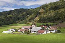
Oberkurzheim was a municipality with 693 inhabitants (as of October 31, 2013) in the judicial district of Judenburg , Murtal district in Styria .
Since 2015, the former municipality has been merged with the municipality of Pöls as part of the Styrian municipal structural reform , the new municipality bears the name " Pöls-Oberkurzheim ".
geography
Geographical location
Oberkurzheim is located in the Austrian state of Styria north of Judenburg in the Pölstal . The lowest point is at around 790 m on the municipal border with Pöls (between Pöls and Gusterheim), the highest point is the Wildingerhöhe at 1721 m on the border with St. Oswald-Möderbrugg and Gaal .
The settlement structure is characterized by individual villages without a direct town center.
Community structure
The municipality comprised eight localities (population in brackets as of January 1, 2020):
- Götzendorf (101 Ew.)
- Katzling (130 Ew.)
- Mauterndorf (182 Ew.)
- Mosing (22 Ew.)
- Oberkurzheim (114 Ew.)
- Thaling (77 Ew.)
- Unterzeiring (16 Ew.)
- Winches (57 Ew.)
The community consisted of two cadastral communities (area: as of December 31, 2019):
- Oberkurzheim (1,420.47 ha)
- Unterzeiring (1,492.30 ha)
Neighboring communities by the end of 2014
| Sankt Oswald-Möderbrugg | Gaal | Gaal |
| Oberzeiring |

|
Pöls |
| Sankt Georgen ob Judenburg | Sankt Georgen ob Judenburg | Pöls |
history
Oberkurzheim was first mentioned in a document in 1140. The settlements in Mosing, Thaling, Götzendorf, Mauterndorf, Katzling, Winden and Unterzeiring emerged later. In the 12th century, the princely toll station was created in the middle of the valley in the village of Katzling.
The high court in the Birkachwald near Unterzeiring and the gallows were mentioned in a document in 1574. The Liechtensteiners had the seat of the district judge in Unterzeiring. The remains of the gallows can still be admired today as a tourist attraction in Katzling. Today the "Katzlinger Wirt" is located in the former courthouse.
The political community Oberkurzheim was established in 1849/50.
politics
The municipal council consisted of nine members and, since the municipal council election in 2010, has consisted of mandataries from the following parties:
coat of arms
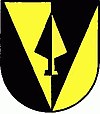
The municipal coat of arms was awarded with effect from June 1, 1998.
Blazon (coat of arms description):
- "In a shield split by black and gold, a turned-up point of mistaken color, inside a plow iron, mistaken in color."
Culture and sights
Buildings
- Old silver mine in the military bunker mountain near Katzling-Klum with many old tunnels
- Gallows at Unterzeiring
- Poor sinners chapel at the high court in the Birkachwald
societies
- Volunteer fire brigade Götzendorf
- USV Oberkurzheim section tennis
- Oberkurzheim stage
- Oberkurzheim riding group
- Country youth in Oberkurzheim
- ÖKB Pöls-Oberkurzheim
Sports
- The community's own fun court is freely accessible to everyone and offers plenty of play opportunities for groups.
Economy and Infrastructure
traffic
The Triebener Straße B 114 runs through the Pölstal in the municipality from southeast to northwest . Coming from Pöls, it leads through Thaling, Mauterndorf and Katzling. Unterzeiring has been bypassed south by the B 114 since 2001. In Katzling, Götzendorferstrasse L 533 branches off to the east of the B 114 and leads to the left of the Pöls river through Götzendorf, past Thaling, Moosing, Oberkurzheim and Pöls to Rattenbergerstrasse L 503. Between Thaling and Gusterheim, it formed the former municipal boundary to Pöls. Neither Oberkurzheim nor the other communities upstream in the Pölstal have a connection to the railway network. The closest passenger station is in Thalheim .
Established businesses
The Hasler Prefabricated House company building is a very striking point in the center of Katzling .
Other companies
- Autohaus Franz Kritz in Unterzeiring
- Holzbau Kandler Alfred in Thaling
- IB Innovative Business GmbH in Katzling
Personalities
Honorary citizen
- 1987: Josef Krainer (1930–2016), governor
Web links
Individual evidence
- ↑ Announcement of the Styrian state government of November 14, 2013 on the unification of the market community of Pöls and the community of Oberkurzheim, both political district of Murtal. Styrian Provincial Law Gazette of December 2, 2013, No. 41, 34th piece, ZDB -ID 705127-x , p. 672, in the version of the change (part of the name “-Oberkurzheim” added to the future municipality name) by the announcement of the Styrian Provincial Government of March 27, 2014 , with which the announcement about the unification of the market community Pöls and the community Oberkurzheim, both political district Murtal, is changed.
- ↑ Statistics Austria: Population on January 1st, 2020 by locality (area status on January 1st, 2020) , ( CSV )
- ↑ (1,094 KB) ; accessed on January 10, 2020
- ↑ General State Law and Government Gazette for the Crown Land of Styria, Issue 21, October 7, 1850, No. 378
- ^ Announcements from the Styrian Provincial Archives 49, 1999, p. 56.


