
Kesselberg (Haardt)
| Kesselberg | ||
|---|---|---|
 Summit area of the Kesselberg |
||
| height | 661.8 m above sea level NHN | |
| location | near Edenkoben and Rhodt unter Rietburg ; District of Südliche Weinstrasse , Rhineland-Palatinate ( Germany ) | |
| Mountains | Haardt ( Palatinate Forest ) | |
| Coordinates | 49 ° 17 '6 " N , 8 ° 2' 40" E | |
|
||
| rock | Red sandstone | |


The Kesselberg is 661.8 m above sea level. NHN is the second highest mountain in the Palatinate Forest after the Kalmit ( 672.6 m ) and the third highest in the Palatinate (highest Donnersberg 686.5 m ). It lies on the border between Edenkoben and Rhodt unter Rietburg in the Rhineland-Palatinate district of Südliche Weinstrasse .
geography
location
The Kesselberg rises in the Pfälzerwald-Vosges du Nord biosphere reserve and in the Palatinate Forest Nature Park . Its summit is on the border of the forest markings of Edenkoben von Rhodt unter Rietburg - 6 km west of Edenkoben, 4.8 km west-northwest of Rhodt unter Rietburg and 3.4 km northwest of Weyher in the Palatinate .
To the east of the wooded Kesselberg, parts of the Haardtrand bird sanctuary (VSG no. 6514-401; 147.28 km² ) reach the mountain at the Meerlinsenbrunnen in the north, at the Kohlplatz ( 465.9 m ) mountain pass in the middle and at the Meisentalbach in the south .
Natural allocation
The Kesselberg belongs to the Palatinate Forest natural area, which is classified as a third-order Greater Region in the systematics of the handbook of the natural structure of Germany published by Emil Meynen and Josef Schmithüsen and its subsequent publications . Looking at the internal structure of the natural area , the Kesselberg belongs to the Middle Palatinate Forest and here to the Haardt mountain range, which separates the Palatinate Forest from the Upper Rhine Plain .
In summary, the natural spatial allocation of the Kesselberg follows the following system:
- Greater region 1st order: Layer level land on both sides of the Upper Rhine Rift
- Greater region 2nd order: Palatinate-Saarland layer level land
- Greater region 3rd order: Palatinate Forest
- 4th order region (main unit): Middle Palatinate Forest
- 5th order region: Haardt
Flowing waters
The Wiesgraben (Tiefenbach, Triefenbach) rises north of the Kesselberg in the Edenkoben valley , a tributary of the Kropsbach that is fed by the trickle coming from the Meerlinsenbrunnen on the mountain . The Modenbach, fed by the Meisentalbach, flows south of the mountain .
Rock group of spherical rocks
On the summit plateau there are various red sandstone rocks with conspicuous round depressions, marked on hiking maps as glacier hollows. They are protected as a two-dimensional natural monument of the Kugelfelsen rock group . The hollows were created by weathering spherical sandstone sections in the spherical rock horizon of the Karlstal layers .
Older, not verifiable interpretations saw the hollows as Celtic sacrificial bowls or glacier pots ( glacier mills ). However, glacier pots require a mighty ice cover, which must have been over the area. Evidence for this, for example glacier scrapes etc., is missing in the entire Palatinate area.
Traffic and walking
A little south past the Kesselberg leads from Ramberg in the southwest lying valley of the Dernbach and then in the Modenbachtal to Weyher in the Palatinate in the east running state road 506. At the Bergsüdfuß - near the confluence of the Meißentalbach in the Modenbach - from the L 506 branches off the one below the nearby Meistersel Castle ( Modeneck ruins ; 491.5 m ) in the Modenbachtal valley Modenbacherhof (approx. 307 m ), the forester's house Heldenstein and the mountain on its northern slope passing Kreisstraße 6, which then leads on to Edenkoben . A little downstream in the Modenbachtal , the K 58 branches off from the L 506 to Burrweiler .
The mountain can be accessed from Benderplatz ( 565.5 m ) in the northwest and Kohlplatz ( 465.9 m ) in the east-southeast; There are spiders on both mountain passes . From the main hiking trail that connects the two, a small hiking trail established in 1953 and named after the historian Friedrich Sprater branches off to the summit. The Benderplatz can be reached from the Lolosruhe hikers' car park and the forester's house Heldenstein , the Kohlplatz from the Modenbachtal and the Edenkobener Valley at the Edenkobener Hut ( 367 m ).
There is practically no prospect of neighboring regions in the Palatinate Forest due to the complete forest cover on the Kesselberg. From the Upper Rhine Plain , the mountain is covered by the Blättersberg ( 613.2 m ) to the southeast .
Picture gallery

Ritterstein 185 on the Dr. Sprater path
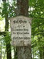
Old nameplate on the Kesselberg (July 2005) with reference to "Gletschermühlen"
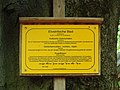
New sign on the Kesselberg (May 2012)

Spherical rocks, general view
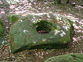
Spherical rocks, partial view


Individual evidence
- ↑ a b Topographic map of the LANIS: Kesselberg. Retrieved January 26, 2017 . , on map1.naturschutz.rlp.de
- ↑ Map services of the Federal Agency for Nature Conservation ( information )
- ↑ Adalbert Pemöller: Geographical land survey: The natural spatial units on sheet 160 Landau i. d. Palatinate. Federal Institute for Regional Studies, Bad Godesberg 1969. → Online map (PDF; 4.2 MB)
- ↑ Helmut Beeger u. a .: The landscapes of Rheinhessen-Pfalz - naming and spatial delimitation. In: Reports on German regional studies , Volume 63, Issue 2, Trier, 1989, pp. 327–359
- ↑ ND-7337-181, cf. Data export of natural monuments (areas) to: Nature Conservation Administration Rhineland-Palatinate: Landscape information system of the Nature Conservation Administration Rhineland-Palatinate ; Retrieved April 11, 2015