
Kiełpino (Brojce)
| Kiełpino | |||
|---|---|---|---|

|
|
||
| Basic data | |||
| State : | Poland | ||
| Voivodeship : | West Pomerania | ||
| Powiat : | Gryfice | ||
| Gmina : | Brojce | ||
| Geographic location : | 53 ° 56 ' N , 15 ° 24' E | ||
| Residents : | 292 (Dec. 31, 2010) | ||
| Postal code : | 72-304 (Brojce) | ||
| Telephone code : | (+48) 91 | ||
| License plate : | ZGY | ||
| Economy and Transport | |||
| Street : | DW105 Rzesznikowo - Gryfice | ||
| Next international airport : | Szczecin-Goleniów | ||


Kiełpino ( German Kölpin ) is a village in the West Pomeranian Voivodeship in Poland . It belongs to the Gmina Brojce (municipality of Broitz) in the powiat Gryficki (district of Greifenberger) .
Geographical location
The village lies in Pomerania , about four kilometers southeast of Brojce, 14 kilometers east of Gryfice ( Greifenberg ) and 81 kilometers north-east of the regional capital Szczecin ( Szczecin ).
history
The so-called Kolpiner Land , in which today's Kiełpino is located, had previously belonged to a feudal knightly estate of the Manteuffel family, who had a castle here as ancestral home in Pomerania since 1315 (Castrum Olden), which is now only surrounded by the remains of a castle hill can be seen from a moat. In the 18th century, Kölpin was divided into four parts. The ownership of the estate changed several times later. Among the owners was Johann Wilhelm Christoph Steobanus von Wriechen , who owned the Kölpin C share around 1800.
During the separation in the 19th century (after 1846), the Braunshof and Henselskathen farms were separated from Kölpin and assigned to the newly formed Popiel-Seebeck community .
Until 1945, Kölpin was a municipality in the Kolberg-Körlin district of the Pomeranian province . In addition to the village of Kölpin, the community also included the Grandhof , Kölpiner Mühle , Neukölpin , Schmuckenthin and Vogelsang residential areas .
After the end of the war, the region became part of Poland together with all of the Pomerania. The village was given the Polish name "Kiełpino" and is now part of the Gmina Brojce (municipality Broitz) , in which it forms a Schulzenamt with Smokęcino (Schmuckenthin) and Raciborów (Vogelsang) .
Development of the population
- 1816: 246 inhabitants
- 1864: 644 inhabitants
- 1885: 600 inhabitants, 391 of them in the rural community of Kölpin, 29 in the Kölpin A estate and 180 in the Kölpin B estate
- 1905: 505 inhabitants, 330 of them in the rural community of Kölpin, 100 in the Kölpin A estate and 75 in the Kölpin B estate
- 1925: 570 inhabitants, 491 of them in the rural community of Kölpin and 70 in the Kölpin manor district
- 1933: 717 inhabitants, rural community Kölpin including Schmuckenthin
- 1939: 696 inhabitants, rural community Kölpin including Schmuckenthin
church
The oldest parts of the Kiełpino village church date from the Romanesque period and can be dated to the 13th century. The main part, however, has features of Gothic construction ( early Gothic ) and probably comes from the transition period between both styles. A pastor in Kölpin was mentioned for the first time in 1328, and the church was mentioned in 1594 as St. Catherine's Church . The main house has a single nave and is a Gothic brick building on a field stone base with a half-timbered tower. The buttresses that can be seen from the outside are rudiments of a medieval preparation for vaulting. Before 1934 these were removed except for 4 pillars on the choir. A wide, pointed triumphal arch is located between the choir and the nave. The south portal is richly profiled, the windows on the nave are pointed and have no tracery . The west gable now contains the main portal, which is crowned by three identical, pointed arched wall panels divided in the middle. The tower was added later and protrudes from the building as a pointed clapboard helmet. The belfry is based on four oak stands, which are closed off as partitions.
The inventory today includes an altarpiece and a pulpit from the Baroque period with elaborate carvings. The altarpiece is structured in the middle as an altarpiece framed by columns, Christ on the cross . Figures of John the Baptist and Moses on both sides.
Before 1945 the local population was predominantly of Protestant denomination. The church was the mother church, which, in addition to Broitz, once included the branches Pinnow ( Pniewo ), Prust ( Pruszcz , branched off since 1907), Behlkow ( Bielikowo ), Suckow , Wendisch Pribbernow ( Przybiernowo ) and the town of Glitzkow . In 1940 the entire parish of Kölpin had 1,082 parish members, since only Pinnow with the local daughter church remained in the parish. It belonged to the church district Greifenberg i. Pom. in the eastern parish of the church province of Pomerania of the Church of the Old Prussian Union . The last German clergyman was Pastor Joachim Vahl .

Village church (2008)

West gable

South portal of the church

Long nave with a view of the choir
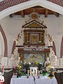
Baroque altar of the Kölpiner Church
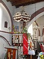
Baroque pulpit

.jpg)


Castle (Castrum Olden)
literature
- Manfred Vollack : The Kolberger Land. Its cities and villages. A Pomeranian homeland book. Husum Druck- und Verlagsgesellschaft, Husum 1999, ISBN 3-88042-784-4 , pp. 349-366.
- Ludwig Böttger : The architectural and art monuments of the administrative district of Köslin. Issue 1, Stettin 1859.
Web links
- Kölpin on the website of the Kolberger Lande association
Footnotes
- ↑ Together with Kiełpinko . Source: Główny Urząd Statystyczny, Portret miejscowości statystycznych w gminie Brojce (powiat gryficki, województwo zachodniopomorskie) w 2010 r. Online query
- ^ Association for the history of the Mark Brandenburg : Märkische researches . Volume 10, Ernst & Korn Verlag, 1867, [1]
- ↑ E. von Glasenapp : Contributions to the history of the old Inter Pomeranian family of the hereditary, castle and palace-sat von Glasenapp . Volume 2, 1897, [2]
- ^ A b Heinrich Berghaus : Land book of the Duchy of Pomerania and the Principality of Rügen . Part III, Volume 1, Anklam 1967, pp. 360-362
- ^ Manfred Vollack : The Kolberger Land. Its cities and villages. A Pomeranian homeland book. Husum Druck- und Verlagsgesellschaft, Husum 1999, ISBN 3-88042-784-4 , p. 548.
- ^ Community Kölpin in the information system Pomerania.
- ^ Website of the municipality of Brojce, Witamy w Gminie Brojce ( Memento of the original from August 19, 2014 in the Internet Archive ) Info: The archive link has been inserted automatically and has not yet been checked. Please check the original and archive link according to the instructions and then remove this notice. , accessed February 8, 2018.
- ↑ a b c d e f g Manfred Vollack : The Kolberger Land. Its cities and villages. A Pomeranian homeland book. Husum Druck- und Verlagsgesellschaft, Husum 1999, ISBN 3-88042-784-4 , p. 353.

Districts: Bielikowo (Behlkow) | Brojce (Broitz) | Dargosław (Dargislaff) | Darżewo (Darsow) | Kiełpino (Kölpin) | Mołstowo (Molstow) | Pruszcz (Prust) | Przybiernowo (Wendisch Pribbernow) | Strzykocin (Streckenthin) | Tąpadły (dummy needle) | Żukowo (Suckowshof)
Other localities: Cieszyce (Karolinenhof) | Grąd (Grandhof) | Łatno (Altendorf) | Mołstówko | Raciborów (Vogelsang) | Smokęcino (jewelry thhin) | Stołąż (Stölitz) | Uniestowo (Nestau)