Reichenbach (Kahl)
|
Reichenbach ( Historically : Heimbach ) |
||
|
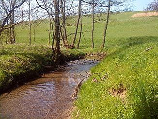
The Reichenbach after the Heimbacher Mühle |
||
| Data | ||
| Water code | DE : 247726 | |
| location |
Spessart
|
|
| River system | Rhine | |
| Drain over | Kahl → Main → Rhine → North Sea | |
| origin | The confluence of the Schützbach and Kirchengrundbach rivers in Reichenbach 50 ° 2 ′ 38 ″ N , 9 ° 8 ′ 24 ″ E |
|
| Source height | 219 m above sea level NHN (at the confluence) | |
| muzzle | at Mömbris in the Kahl coordinates: 50 ° 3 '47 " N , 9 ° 10' 44" E 50 ° 3 '47 " N , 9 ° 10' 44" E |
|
| Mouth height | 169 m above sea level NHN | |
| Height difference | 50 m | |
| Bottom slope | 11 ‰ | |
| length | 4.5 km from the confluence
6.5 km with Schützbach |
|
| Catchment area | 15.744 km² | |
| Left tributaries | Hohlenbach , Heimbach | |
| Right tributaries | Steinbach | |
|
The Reichenbach shortly before it flows into the Kahl |
||
The Reichenbach is a left tributary of the Kahl in the district of Aschaffenburg in the Bavarian Spessart . It arises from the confluence of the Schützbach and Kirchengrundbach in Reichenbach .
Surname
The name Reichenbach consists of the Middle High German words rîche and bach and means "rich brook". This refers either to the rule that populated the body of water or to the stream and means rich in fish or water. The brook gave the place Reichenbach its name.
The earlier name Heimbach should not be confused with the left tributary, which is also called Heimbach.
geography
Spring streams
Schützbach
The Schützbach rises in a valley below Johannesberg- Sternberg. It first flows north to Reichenbach , where it meets the 'Langen Grund' and bends to the northeast. At around 2.0 km, the Schützbach is the more water-rich and longer source stream and is viewed as the upper reaches of the Reichenbach .
Kirchengrundbach
The approximately 1.5 km long Kirchengrundbach rises below the state road 2309 in a valley between Johannesberg and Reichenbach. It flows north to Reichenbach, where it joins the Schützbach to form the Reichenbach .
course
After the confluence of the source streams, the Reichenbach flows to the northeast, where it used to run the Reichenbacher Mühle . At the mouth of the Hohlenbach , from the so-called Hutzelgrund, is the Heimbacher Mühle . Since this brook has too little headwater, water is taken from the Reichenbach via an artificially created ditch, which is fed via a pipe over the Hohlenbach and feeds the mill. The Hohlenbach flows into the other Reichenbacharm.
The Reichenbach continues on the western slope of the Glasberg , joins the Heimbach from the left and reaches the Kahltal . There the Reichenbach crosses under the state road 2305 and flows into the Kahl opposite the Sterzenbach .
Alongside the Geiselbach , Sommerkahl and Westerbach, the Reichenbach is one of its largest tributaries.
Tributaries
- Schützbach (left source stream)
- Kirchengrundbach (right source stream)
- Steinbach (right)
- Hohlenbach (left)
- Heimbach (left)
Kahl river system
Hydrology
Flood

(Taken on the St 2305 in the direction of Heimbacher Mühle.) The usual stream bed runs in the row of trees on the right.
In May 1922, severe storms hit the Kahlgrund . Reichenbach was hit particularly badly . Only a few thick drops fell in the first few minutes. This was followed by a strong hailstorm and within a short time the pigeon egg-sized grains were 5 to 10 centimeters high. The hail turned into a huge downpour that lasted at least two hours. Huge masses of water were created in a flash. The Reichenbach became a raging river. A huge lake about two meters deep formed in the center of Reichenbach.
All of the farmers' cattle were carried away and eventually drowned. Whole huts and barns were swept away by the water. The flood tore a 6 m deep and 30 m wide ditch in the landscape. The next morning, driftwood and mud lay in the meadow of the Reichenbach , an area as wide as the Main . The material of the barns was probably driven into the bald , it was found again in the Alzenau city area.
On July 29, 2014, heavy rains fell over the Reichenbachtal, which caused the level of the creek to rise unusually.
history
Mills
- Wombacher mill
- Reichenbacher Mill
- Heimbacher Mill
See also the list of mills in the Kahlgrund .
See also
Web links
Individual evidence
- ↑ Bayernviewer of the Bavarian Surveying Administration: Historical maps from the years 1817–1841 ( Memento of the original from March 4, 2016 in the Internet Archive ) Info: The archive link was inserted automatically and has not yet been checked. Please check the original and archive link according to the instructions and then remove this notice. (The Heimbach originated from the confluence of Reichenbach and Hohlenbach)
- ↑ a b c Bavaria Atlas of the Bavarian State Government ( notes )
- ↑ a b GeoFachDatenAtlas and water services of the Bavarian State Office for the Environment
- ↑ Our Kahlgrund 1980 . Homeland yearbook for the Alzenau district. Published by the working group for homeland research and homeland maintenance of the Alzenau district, district administrator. ISSN 0933-1328 .
- ↑ Topographic map of Alzenau i. UFr. 1: 25000
- ^ Gerhard Nees & Hermann Kehrer: Alzenauer Wetterchronik . The most interesting weather events in Alzenau, in the Kahlgrund and on the Untermain from 365 to 1999. Reinhold Keim Verlag, Großkrotzenburg 2002, ISBN 3-921535-51-4 .


