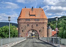
State Road 2309
| State Road 2309 | |
|---|---|
| St 2309 | |
| Basic data | |
| Operator: | Free State of Bavaria |
| Start of the street: | at Mömbris ( 50 ° 4 ′ N , 9 ° 10 ′ E ) |
| End of street: | near Miltenberg ( 49 ° 39 ′ N , 9 ° 18 ′ E ) |
| Overall length: | 61 km |
|
State : |
Bavaria |
The national road 2309 (abbreviation: St 2309) is a 61 km long state road in the counties of Aschaffenburg and Miltenberg in Unterfranken that of Moembris about Aschaffenburg to Miltenberg as rechtsmainische major route on Bavarian Untermain runs. It leads in a north-south direction, partially parallel to the federal highway 469 on the opposite bank of the Main , which complements it in its function. The state road 2309 represents an important connection from medium-sized centers to the regional center of Aschaffenburg, also takes the traffic from the eastern Spessart communities in its collecting function and forwards them in the direction of the Rhine-Main area .
geography
course
It begins in the Kahlgrund in the northwestern part of the Spessart near Mömbris on the St 2305 . At the Heimbacher Mühle it meets the St 2443. In the further course the state road 2309 leads through the places Reichenbach , Johannesberg and Oberafferbach , past Glattbach , to Aschaffenburg, where it crosses the Aschaff river.
There, State Road 2309 runs via Dyroffstraße , Schillerstraße , Burchardtstraße and Müllerstraße to the B 8 / B 26 and on via Luitpoldstraße , Landingstraße , Wermbachstraße , Schweinheimer Straße , Pestalozzistraße , Südbahnhofstraße to Maintalstraße . After crossing the Obernau district along the Aschaffenburg – Miltenberg railway line , it leaves Aschaffenburg.
The state road 2309 then leads on the right side of the Main along the railway line through the town of Sulzbach am Main , where the St 2313 branches off to Niedernberg . State road 2309 reaches Elsenfeld through the village of Kleinwallstadt . This is where the St 2308 joins and both cross the river Elsava on the same route .
Via Erlenbach am Main , Klingenberg am Main , Röllfeld , the Grubingen desert and Großheubach , state road 2309 continues to Miltenberg. The street is divided in the urban area. The older route passes the Main over the old Main Bridge and leads along the promenade through the northern old town. The new state road (St 2309n) leads through a tunnel, crosses the river over the new Main Bridge and meets the old route again in the municipality of Bürgstadt . Then the state road 2309 reaches the northeastern Odenwald via the “Wenschdorfer Steige” . At Geisenhof , at the state border with Baden-Württemberg , it turns into state road 518 , which then continues to Walldürn .
State road 2309 leads through built-up areas, meadows and fields as well as through forest areas.

Waters crossed
State road 2309 crosses the following rivers (from north to south):
|
topography
State road 2309 overcomes about ± 1100 meters in altitude over its entire course . The topographically lowest point of the route is 112 m above sea level. NHN in the underpass of the Maintalbahn north of Obernau. The highest is at 458 m above sea level. NHN west of Wenschdorf .
history
Previous route
- In 2011 the Obernau bypass was opened. State road 2309 has not passed through the town center since then.
- State road 2309 ran through the town until the Elsenfeld bypass was completed.
Planning
- Sulzbach am Main is a ring road on the embankment of the Main Valley Railway planned.
- In Kleinwallstadt, the 2309 state road is to lead from the Elsenfeld bypass to the other side of the Main on the 469 federal road to relieve the traffic in Kleinwallstadt.
Attractions
There are around 15 archaeological monuments and 90 architectural monuments directly on State Road 2309 . The following list contains a selection of them:
- Catholic parish church of St. Johannis Beheading in Johannesberg
- Schönborner Hof in Aschaffenburg
- Fortification of Sulzbach am Main
- Fortification of Kleinwallstadt
- Historic town hall of Großheubach
- Main bridge Miltenberg
- Limes near Miltenberg
See also
Web links
Individual evidence
- ↑ a b BayernAtlas of the Bavarian State Government ( notes )
- ^ St 2309 - Kleinwallstadt bypass with a new bridge over the Main south of Kleinwallstadt
- ↑ St 2309 at www.stbaab.bayern.de
- ↑ Contour lines on the BayernAtlas.
- ↑ Main-Echo dated May 28, 2011 Hundreds of Obernau residents cheer on the relief road (fee required)
- ^ OU Sulzbach in the BayernAtlas
- ↑ Bavarian Monument Atlas (cartographic representation of the Bavarian architectural and ground monuments by the Bavarian State Office for Monument Preservation (BLfD) )

