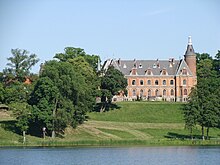
Klecewo (Gardeja)
| Klecewo | ||
|---|---|---|

|
|
|
| Basic data | ||
| State : | Poland | |
| Voivodeship : | Pomerania | |
| Powiat : | Kwidzyński | |
| Gmina : | Gardeja | |
| Geographic location : | 53 ° 38 ' N , 19 ° 7' E | |
| Residents : | 230 (2011) | |
| Postal code : | 82-520 | |
| Telephone code : | (+48) 55 | |
| License plate : | GKW | |
| Economy and Transport | ||
| Next international airport : | Danzig | |
Klecewo ( German Klötzen ) is a village in the rural municipality of Gardeja (Garnsee) in the Powiat Kwidzyński of the Pomeranian Voivodeship in Poland .
Geographical location
The village is located in the former West Prussia , about six kilometers south of Nowa Wioska (Neudörfchen) and 18 kilometers southeast of Kwidzyn (Marienwerder) on Lake Gallnau.
history

In 1789, Klötzen is referred to as a noble farm with an outwork and twelve fireplaces (households). In the first half of the 19th century, the manor was owned by the Rosenberg-Gruszczynski family . Around 1876 the real privy councilor and royal chamberlain, Baron von Rosenberg, sat on the Klötzen manor. In the Franco-Prussian War (1870–1871) he lost two nephews, of which the younger, 23-year-old Max Emil Adalbert von Rosenberg-Gruszczynski (1847–1870), who was born in Gallnau, was buried in the family crypt on Klötzen in the fall of 1870 was.
Due to the provisions of the Versailles Treaty , the population in the Marienwerder voting area , to which Klötzen belonged, voted on July 11, 1920 on whether they would continue to belong to East Prussia (and thus to Germany) or join Poland. In Klötzen, 131 residents voted to remain with East Prussia, Poland did not cast any votes.
By merging the five manor districts
- Gallnau
- Germen
- Great Tromnau
- Blocks
- Tubercles
The new rural community of Klötzen was established in 1928.
In 1945 the municipality of Klötzen belonged to the Marienwerder district in the Reichsgau Danzig-West Prussia of the German Empire .
Towards the end of the Second World War , the region was occupied by the Red Army in early 1945 after fighting with the Wehrmacht . In the summer of 1945, according to the Potsdam Agreement , Klötzen was placed under Polish administration by the Soviet occupying forces, along with all of West Prussia and the southern half of East Prussia . As far as the residents had not fled, they were expelled from Klötzen in the following period .
Demographics
| year | Residents | Remarks |
|---|---|---|
| 1816 | 149 | |
| 1864 | 227 | including 220 Evangelicals and seven Catholics |
| 1871 | 630 | |
| 1933 | 917 | |
| 1939 | 879 |
Parish
Until 1945 the evangelical church members of the village were parish in the parish of the Groß Tromnau manor . The church building was built in 1330 and was extensively restored in 1851. A roof turret was added in 1873. In 1945 the roof was renovated.
Most of the current residents of the village belong to the Roman Catholic denomination.
Personalities
- Horst von Rosenberg-Gruszczynski (1855-1923), Prussian lieutenant general , was born in the Gallnau district.
literature
- Daniel Heinrich Arnoldt : Brief messages from all preachers who have admitted to the Lutheran churches in East Prussia since the Reformation . Königsberg 1777, pp. 411-412.
Web links
- Otspreußen.net: Trumieje - Groß Tromnau
- District of Klötzen (Rolf Jehke, 2004)
Individual evidence
- ^ Johann Friedrich Goldbeck : Complete topography of the Kingdom of Prussia. Volume 2: Topography of West Prussia . Kantersche Hofdruckerei, Marienwerder 1789, Complete Topography of the West Prussian Cammer Department , p. 94.
- ^ Leopold von Zedlitz-Neukirch : New Preussisches Adels-Lexicon . Volume 4, Leipzig 1837, pp. 129-130.
- ^ Journal of the historical association for the administrative district Marienwerder . Volume 1, Marienwerder 1876, p. 258.
- ^ Wilhelm Krause: Memorial hall of the officers of the German army who fell in the 1870-71 campaign and who subsequently died . Cronbach, Berlin 1873, columns 407-408.
- ↑ Herbert Marzian , Csaba Kenez : "Self-determination for East Germany - A Documentation on the 50th Anniversary of the East and West Prussian Referendum on July 11, 1920"; Editor: Göttinger Arbeitskreis , 1970, p. 119
- ↑ District of Klötzen (Rolf Jehke, 2004)
- ↑ Alexander August Mützell and Leopold Krug : New topographical-statistical-geographical dictionary of the Prussian state . Volume 2: G – Ko , Halle 1821, p. 353.
- ^ E. Jacobson: Topographical-statistical manual of the Marienwerder administrative district . Danzig 1868, pp. 104-105, paragraph 121.
- ^ Gustav Neumann: Geography of the Prussian State . 2nd edition, Volume 2, Berlin 1874, pp. 48-49, item 2.
- ^ A b Michael Rademacher: German administrative history from the unification of the empire in 1871 to the reunification in 1990. marienwerder_op.html # ew33mwopkloetzen. (Online material for the dissertation, Osnabrück 2006).


