Kohlschlag (Lauf an der Pegnitz)
|
Cabbage cut
City of Lauf an der Pegnitz
Coordinates: 49 ° 29 ′ 30 ″ N , 11 ° 20 ′ 43 ″ E
|
|
|---|---|
| Height : | 387 m above sea level NN |
| Residents : | 8 (Dec 31, 2008) |
| Postal code : | 91207 |
| Area code : | 09123 |
|
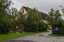
Kohlschlag poultry farm
|
|
Kohlschlag is a district of the city of Lauf an der Pegnitz in the district of Nürnberger Land in Middle Franconia / Bavaria . It consists of a homestead with a riding stable. The wasteland is surrounded by forests and is located between Schönberg , Ottensoos and Rüblanden . Three brooks, the Bockgraben , the Veitsbach and the Kreuzbach , have their source near the village . You can reach the farm from the connecting road from Weigenhofen to Ottensoos via an access road.
On July 1, 1972, the community Weigenhofen, to which Kohlschlag belonged, was incorporated into the town of Lauf an der Pegnitz.
literature
- Nuremberg country . Karl Pfeiffer's Buchdruckerei und Verlag, Hersbruck 1993. ISBN 3-9800386-5-3
Individual evidence
- ↑ lauf.de: Population (accessed on 8 July 2015)
- ^ Wilhelm Volkert (ed.): Handbook of Bavarian offices, communities and courts 1799–1980 . CH Beck, Munich 1983, ISBN 3-406-09669-7 , p. 510 .
Web links
Commons : Kohlschlag (Lauf an der Pegnitz) - Collection of images, videos and audio files

