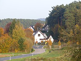
Simonshofen
|
Simonshofen
City of Lauf an der Pegnitz
Coordinates: 49 ° 33 ′ 6 ″ N , 11 ° 16 ′ 8 ″ E
|
|
|---|---|
| Height : | 374 m above sea level NHN |
| Residents : | 735 (Nov. 1, 2017) |
| Incorporation : | 1st January 1973 |
| Postal code : | 91207 |
| Area code : | 09123 |
|
The district of Lauf Simonshofen
|
|
Simonshofen is a district of the Middle Franconian town of Lauf an der Pegnitz in the district of Nürnberger Land .
geography
The village is located about four kilometers north of the center of Lauf and is at an altitude of 374 m above sea level. NHN .
history
The village of Simonshofen has developed from the Sigman farm mentioned in 1360. Hop growing was mentioned there as early as 1375 . In 1333, Konrad Groß from Nuremberg acquired the goods and properties that he brought into the foundation of the Heilig-Geist-Spital, which he established. For more than 600 years the hospital authority exercised community rule, paid a school teacher and a forester. In 1806 the place came to the district of Lauf an der Pegnitz.
Due to the administrative reforms in the Kingdom of Bavaria at the beginning of the 19th century , the place became a rural municipality with the Second Municipal Edict. In the course of the municipal reform in Bavaria in the 1970s, the municipality of Simonshofen was incorporated into the city of Lauf on January 1, 1973. In 2017 Simonshofen had 735 inhabitants.
Attractions
There are sixteen monuments in Simonshofen, including several farms, stables and barns. There are two stone crosses at the Höllweiher .
See: List of architectural monuments in Simonshofen
literature
- Eckhardt Pfeiffer (Ed.): Nürnberger Land . 3. Edition. Karl Pfeiffer's Buchdruckerei und Verlag, Hersbruck 1993, ISBN 3-9800386-5-3 .
Web links
- Simonshofen in the BayernAtlas , accessed on January 27, 2019
- Simonshofen on a historical map , accessed on January 27, 2019
Individual evidence
- ↑ Population of Simonshofen on the website of the city of Lauf , accessed on January 27, 2019
- ^ Simonshofen in the local database of the Bayerische Landesbibliothek Online . Bayerische Staatsbibliothek, accessed on January 27, 2019.
- ↑ Geographical location of Simonshofen , accessed on January 27, 2019
- ↑ Political composition of the rural community Simonshofen , accessed on January 27, 2019
- ^ Federal Statistical Office (ed.): Historical municipality directory for the Federal Republic of Germany. Name, border and key number changes in municipalities, counties and administrative districts from May 27, 1970 to December 31, 1982 . W. Kohlhammer, Stuttgart / Mainz 1983, ISBN 3-17-003263-1 . Page 719


