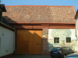
Kornhof (Dirmstein)
| Kornhof | ||
|---|---|---|
 Gatehouse |
||
| Data | ||
| place | Dirmstein | |
| Architectural style | baroque courtyard with gatehouse | |
| Construction year | early 18th century | |
| Coordinates | 49 ° 33 '51.4 " N , 8 ° 14' 55.8" E | |
|
|
||
The Kornhof in the Rhineland-Palatinate municipality of Dirmstein is a rural property , the oldest parts of which were built in the early 18th century. The property is a listed building .
Geographical location
The Hofgut is located in the northeast of the historic Oberdorf at Metzgergasse 19 . Within a radius of 200 m there are other listed buildings, e.g. B. the oldest house , the Laurentiuskirche , the Sturmfedersche Schloss , the old town hall and the St. Michael pharmacy .
building
The driveway is closed by a gatehouse , the outer wall of which is painted plaster and which has an eaves saddle roof . A rusticated sandstone pillar to the right of the passage rests over a cushioned foot.
On the left side of the courtyard is the two-storey masonry house with a high gable roof with a crooked hip on one side . The facade is structured by simple, partially coupled rectangular windows. The inscription "HBM 1836" is carved into the log portal, presumably referring to the owner at the time, Hans Bachmann .
A spacious barn closes the yard; Integrated into it are a barrel-vaulted cellar and a stable vaulted over pillars .
Building history
The previous buildings of the Kornhof were ruined in 1689 when the French burned the entire town down in the Palatinate War of Succession . Probably at the beginning of the 18th century the Kornhof was built from scratch in the late Baroque style. On the map from 1746 it is referred to as the property of Bernhard Rosen with stone house and half-timbered barn . In 1808 the estate was expanded by the purchase of the neighboring farmstead to the west and then partially rebuilt. The building traditions of the late Baroque period were continued. The house behind the gatehouse is attested by an inscription from 1836.
literature
- Georg Peter Karn, Ulrike Weber (arrangement): Bad Dürkheim district. City of Grünstadt, Union communities Freinsheim, Grünstadt-Land and Hettenleidelheim (= cultural monuments in Rhineland-Palatinate. Monument topography Federal Republic of Germany . Volume 13.2 ). Wernersche Verlagsgesellschaft, Worms 2006, ISBN 3-88462-215-3 .
References and comments
- ↑ a b General Directorate for Cultural Heritage Rhineland-Palatinate (ed.): Informational directory of cultural monuments - Bad Dürkheim district. Mainz 2020, p. 29 (PDF; 5.1 MB).
- ↑ The names Oberdorf and Niederdorf for the two settlement centers of the municipality are derived from the location above and below at the Eckbach , which flows through Dirmstein from west to east.
- ↑ Bird chart from 1746 . In: Hessisches Staatsarchiv Darmstadt . P. 1, 418.

