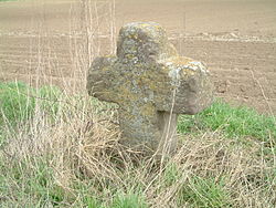
Field Cross (Dirmstein)
| Field cross | ||
|---|---|---|
 Field cross on the road to Offstein |
||
| Data | ||
| place | Dirmstein | |
| Client | presumably Dirmsteiner Jesuit monks | |
| Architectural style | stone cross with minus inscription | |
| Construction year | Late Middle Ages or early modern times | |
| height | almost 0.7 m | |
| Coordinates | 49 ° 34 '24.2 " N , 8 ° 14' 46" E | |
|
|
||
The field cross on the parish of the Rhineland-Palatinate municipality Dirmstein is a stone cross . It is on Landesstraße 455 , which leads from Dirmstein to Offstein .
Geographical location
The location of the field cross at 116 m above sea level. NHN is about 100 m north of the Floßbach and 400 m north of the residential area. The cross is on the eastern side of the state road just over 1 m from the edge of the road, the front facing the road. The Chorbrünnel-Rundweg leads past the cross , which near this point turns at right angles from Offsteiner Straße to the west to reach Chorbrünnel, 500 m away .
Status
The almost 70 cm high sandstone cross has neither a body nor a base . It is in a very bad state of preservation; because because of the proximity of the lanes , environmental influences have attacked the surface of the cross and made it porous. That is why the inscription in late Gothic minuscule is barely legible.
history
The field cross is classified as a cultural monument and, due to its old age, is a rare evidence of its genus in the Upper Palatinate region. Due to the design of the cross and the font used, historical scholarship assumes that the object dates from the 15th or 16th century and can therefore be assigned to the late Middle Ages or early modern times .
The proximity of the Choir Brünnels indicates that the Dirmstein Jesuit monks - they had the well provided with a stone well chamber in the first half of the 16th century so that the sulfur- containing water could be better used for healing purposes - are also responsible for the erection of the cross .
The right-angled course of the raft brook in the area there appears unnatural; rather, the contour lines indicate that the stream was flowing right next to it when the cross was erected. That was about 100 m further north than today.
literature
- Georg Peter Karn, Ulrike Weber (arrangement): Bad Dürkheim district. City of Grünstadt, Union communities Freinsheim, Grünstadt-Land and Hettenleidelheim (= cultural monuments in Rhineland-Palatinate. Monument topography Federal Republic of Germany . Volume 13.2 ). Wernersche Verlagsgesellschaft, Worms 2006, ISBN 3-88462-215-3 .
Web links
- Location of the field cross on: Map service of the landscape information system of the Rhineland-Palatinate nature conservation administration (LANIS map) ( notes )
Individual evidence
- ↑ Map service of the landscape information system of the Rhineland-Palatinate nature conservation administration (LANIS map) ( notes )
- ↑ a b Georg Peter Karn, Ulrike Weber (arrangement): Bad Dürkheim district. City of Grünstadt, Union communities Freinsheim, Grünstadt-Land and Hettenleidelheim (= cultural monuments in Rhineland-Palatinate. Monument topography Federal Republic of Germany . Volume 13.2 ). Wernersche Verlagsgesellschaft, Worms 2006, ISBN 3-88462-215-3 .
- ↑ a b General Directorate for Cultural Heritage Rhineland-Palatinate (ed.): Informational directory of cultural monuments - Bad Dürkheim district. Mainz 2020, p. 30 (PDF; 5.1 MB).

