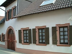
Smithy (Dirmstein)
| Wrought | ||
|---|---|---|
 Former forge |
||
| Data | ||
| place | Dirmstein | |
| Architectural style | baroque gatehouse construction | |
| Construction year | First quarter of the 18th century | |
| Coordinates | 49 ° 33 '47.9 " N , 8 ° 14' 41.6" E | |
|
|
||
The former blacksmith's shop in the Rhineland-Palatinate municipality of Dirmstein is a rural, artisanal property that was built in the early 18th century and used as a blacksmith's workshop. It is a listed building .
Geographical location
The listed part of the property extends along Herrengasse 14 in the monument zone of the upper village . The courtyard behind it surrounds farm buildings that were subsequently significantly changed and are therefore not classified as worthy of protection.
building
The one-and-a-half-storey brick house was originally the greatly expanded gatehouse of a hooked courtyard . It consists of three parts, the dwelling in the middle, the old residential wing on the right and the smaller workshop wing on the left. The plastered façade, which was structured with considerable effort, has dorising corner capitals , richly decorated with an egg stick , which in the past presumably sat above plastered pilasters that included the corner blocks as well as entablature pieces decorated with triglyphs . The cornice was obviously changed during the renewal of the half-hip roof . In the living area there are drilled vertical windows, the former workshop room has arched windows . The passage forms a round arched gate with a volute-shaped keystone , which indicates the purpose of the property with a relief-carved horseshoe. The gate pillars have partly sunk below street level; therefore the gate seems a bit low today. Above it rises the dwelling under a monopitch roof , which probably only took the place of a gable roof later .
Building history
The presumed predecessor property became ruinous in 1689 when the entire place was burned down by French troops during the Palatinate War of Succession . In the first quarter of the 18th century the courtyard was rebuilt from scratch. It is already drawn in on the map of 1746, which became known as the bird's diagram. The building deserves attention primarily because of its sophisticated facade structure, which is related to other Dirmstein buildings from this time, e.g. B. the Gasthof Marktstraße 15, the Gasthaus Drei Könige and the old town hall .
literature
- Georg Peter Karn, Ulrike Weber (arrangement): Bad Dürkheim district. City of Grünstadt, Union communities Freinsheim, Grünstadt-Land and Hettenleidelheim (= cultural monuments in Rhineland-Palatinate. Monument topography Federal Republic of Germany . Volume 13.2 ). Wernersche Verlagsgesellschaft, Worms 2006, ISBN 3-88462-215-3 .
References and comments
- ↑ a b General Directorate for Cultural Heritage Rhineland-Palatinate (ed.): Informational directory of cultural monuments - Bad Dürkheim district. Mainz 2020, p. 28 (PDF; 5.1 MB).
- ↑ The names Oberdorf and Niederdorf for the two settlement centers of the municipality are derived from the location above and below at the Eckbach , which flows through Dirmstein from west to east.
- ^ View of the city of Dirmstein. Hessian State Archive Darmstadt. 1750. Signature: HStAD inventory P 1 No. 418. Link

