Leh
| Leh | ||
|---|---|---|
|
|
||
| State : |
|
|
| Union Territory : | Ladakh | |
| District : | Leh | |
| Location : | 34 ° 10 ′ N , 77 ° 35 ′ E | |
| Height : | 3506 m | |
| Residents : | 30,870 (2011) | |
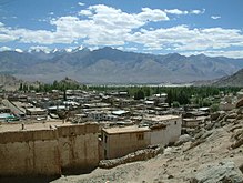
| View over Leh | ||
Leh ( Tibetan གླེ་ Wylie Gle ) is a city ( Municipal Committee ) in the district of the same name and the administrative seat of the Indian Union Territory of Ladakh . Leh is one of the highest permanently inhabited cities on earth. The population was 30,870 in the 2011 census. Large parts of the city were devastated in the flood disaster in summer 2010.
geography
Leh is on the north side of the Indus on a mountainside. The place itself was laid out on the barren slope away from the fertile plateau so as not to obstruct valuable arable land.
climate
There is an arid climate , a rough desert climate. The classification of the climate according to Koppen and Geiger is BWk (cold desert climate). The annual rainfall is only about 103 mm. An annual average temperature of 5.3 ° C is reached in Leh and lies between −20 ° C in winter and +25 ° C in summer. Summers are short and moderately warm and winters are long and cold.
| Leh | ||||||||||||||||||||||||||||||||||||||||||||||||
|---|---|---|---|---|---|---|---|---|---|---|---|---|---|---|---|---|---|---|---|---|---|---|---|---|---|---|---|---|---|---|---|---|---|---|---|---|---|---|---|---|---|---|---|---|---|---|---|---|
| Climate diagram | ||||||||||||||||||||||||||||||||||||||||||||||||
| ||||||||||||||||||||||||||||||||||||||||||||||||
|
Average monthly temperatures and rainfall for Leh
Source: Climate Data
|
||||||||||||||||||||||||||||||||||||||||||||||||||||||||||||||||||||||||||||||||||||||||||
Water supply
The water supply for the agriculture of Leh is mainly based on meltwater from the glaciers from the eastern area of Khardung-La and the western, higher snow fields. Only spring and ground water are used for drinking water. This is obtained from private wells, water tank vehicles and around 390 public water points, 150 of which can also be used in winter.
history
In the past, Leh was part of Greater Ladakh , which stretched from Kailash and Manasarovar to Swaat ( Dardistan ). However, Ladakh was not under the rule or influence of Tibet . The history of the Persians and Chinese shows that a bitter war was waged over this mountain region in the 7th century. The area became a battlefield for the armies.
In the 8th century Persia began to take part in the wars and switched sides between China and Tibet several times . It is known that the ruler of Kashmir , Laltadita, conquered Ladakh.
The original inhabitants were Darden and other Indo-Aryans who came from the lower Indus , but immigration from Tibet for more than a thousand years has made these cultures disappear. The Buddhism reached Tibet Ladakh.
From the 10th century until the founding of India and Pakistan , Ladakh was an independent kingdom on the Silk Road and a bastion of Buddhism.
The status of the area and thus of the region is still not completely clear between India, China and Pakistan.
See also: History of Ladakh
Religions
According to the 2011 census, religious affiliations in Leh are distributed as follows:
- Buddhism: 44%
- Hinduism: 35%
- Islam: 15%
- Sikh: 2.7%
Missionaries of the Moravian Congregation tried to spread the Christian faith in Leh in the nineteenth century.
traffic
Road connections exist via the Manali-Leh Highway , which leads over the Taglang La Pass, the Srinagar-Leh Highway and the road over the Kardung La into the Nubra Valley . Most pass roads are closed in winter, but Kardung La, which is considered to be one of the highest motorable roads in the world, is kept open year-round by the Indian military (the Road Construction Companies ). This military unit is responsible for building and maintaining all major roads in the border area.
The mixed, military and civil, used airport Leh (IATA code: IXL) is located about 3 kilometers southwest of Leh and bears the name of the late Kushok Bakula .
There are daily flight connections to Delhi and several times a week to Srinagar and Jammu . However, due to the low atmospheric density at 3500 meters above sea level, the flights can only take off with a reduced weight, so that only about half as many passengers can be transported per aircraft as when taking off at a regular airport under 1000 meters. Flights can be canceled due to the weather, especially in winter.
economy
In the past, the Silk Road brought prosperity to Leh. Today the two main branches of business are the manufacture of jewelry , mainly from silver, and tourism .
The Ladakh region is unable to produce all the goods and agricultural products it needs itself. Therefore, a lot of food and goods, mostly from the Kashmir region, have to be obtained. Due to the transport routes over high pass roads and their temporary closure in winter, delivery bottlenecks and supply difficulties can occur during this time.
Partly due to the strong military presence , the power supply in particular is temporarily overwhelmed. While the power supply is largely secured in Leh, there may be temporary power outages or interruptions in the region.
Others
As you can see from history, the area was fought over for centuries. Even today there is still no peace between India, Pakistan and China. All three states have troops on the territory of the district.
A number of travel guides warn against traveling to Jammu and Kashmir. Ladakh, and with it Leh, is however to be regarded as peaceful, so that Ladakh is overall the safest area of Kashmir that one can travel to.
In Leh there is the highest golf course in the world, a 9-hole course that is looked after by the Indian army .
See also
Web links
Individual evidence
- ↑ census2011.co.in
- ↑ a b census2011.co.in
- ↑ Climate: Leh . Climate-Data.org. Retrieved May 8, 2018.
- ^ Local framework II: Water resource management systems in Leh town . (PDF) accessed on June 22, 2014.


