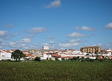
La Albuera (Extremadura)
| La Albuera municipality | ||
|---|---|---|
| coat of arms | Map of Spain | |

|
|
|
| Basic data | ||
| Autonomous Community : |
|
|
| Province : | Badajoz | |
| Comarca : | Tierra de Badajoz | |
| Coordinates | 38 ° 43 ′ N , 6 ° 49 ′ W | |
| Height : | 253 msnm | |
| Area : | 26.37 km² | |
| Residents : | 2,028 (Jan 1, 2019) | |
| Population density : | 76.91 inhabitants / km² | |
| Postal code : | 06170 | |
| Municipality number ( INE ): | 06005 | |
| administration | ||
| Mayor : | Manuel Antonio Díaz González ( PSOE ) | |
| Website : | www.laalbuera.es | |
La Albuera is a village in the Spanish province of Badajoz .
geography
La Albuera is located south of the city of Badajoz near the border with Portugal. In 2019 the place had 2028 inhabitants.
history
The place became famous through the battle of La Albuera . There the combined English, Spanish and Portuguese were victorious under William Beresford on 16 May 1811 the French under Jean-de-Dieu Soult , the Badajoz shocking wanted.
Web links
Commons : La Albuera - Collection of images, videos and audio files
Individual evidence
- ↑ Cifras oficiales de población resultantes de la revisión del Padrón municipal a 1 de enero . Population statistics from the Instituto Nacional de Estadística (population update).

